Wright Brothers at Kitty Hawk

As long as there have been humans watching birds soar through the skies above them, mankind has wanted to fly.   Jean-François Pilâtre de Rozier and François Laurent d’Arlandes  floated skyward above Paris in 1783 using a hot air balloon.  In 1853, George Cayley witnessed the successful manned flight of a glider that he had invented in England.  It was he who identified the four basic principles of flight that a heavier-than-air aircraft uses today:  thrust, gravity, lift, and drag.  He also identified the cambered shape of a bird’s wings, which create lift as air passes over them.

In the 1890’s, two bicycle shop owners from Dayton, Ohio, decided to try their hand at building an airplane.  Orville and Wilbur Wright used Cayley’s principles to construct a two-winged glider.  In order to test it, they needed a location with a soft landing surface (sand), a hill, and sustained winds.  Noting the media circus that had taken place near Chicago when Octave Chanute had tested his gliders, the Wrights were also looking for privacy.  They contacted the weather bureau for locations with the best sustained winds.  Kitty Hawk, North Carolina was chosen, after the hamlet’s postmaster responded favorably to an inquiry from the brothers.  William Tate’s reply included help with the endeavor in any way he could.  The crew of the local U.S. Lifesaving station also offered to lend a hand when needed. In 1900, the Wrights brought their first glider to Kitty Hawk by train to give it a try.  The first tests were flown unmanned and tethered as a kite.  Then Wilbur flew aboard untethered to see if he could control it.  They had come up with an idea they called wing warping…a process in which the wings were bent in one direction or another to steer the plane, along with an elevator to maneuver up and down.  They determined the glider needed to be larger, as they weren’t able to stay in the air long enough to adequately test the controls.  In 1901, they brought a larger glider to Kitty Hawk, only to find that their wings weren’t producing enough lift.  They had been relying on data produced by Germany’s Otto Lilienthal, who had died in 1896 in a glider crash.

After abandoning Lilienthal’s figures and testing 200 wing designs in their homemade wind tunnel, the Wrights set out for Kitty Hawk in late 1902 to try out their new glider.  They had also added a rudder to the plane, thereby giving them three ways to control it.  It worked.  Over a one month period, they made approximately 1,000 flights…with one being 622 feet.  Systems they developed that year, are still the basis for aircraft today.

In 1903, they decided to add power to their aircraft.  Their bike shop employee, Charlie Taylor, machined a light weight engine for them out of a solid block of aluminum.  The Wrights fashioned propellers out of laminated wood. They had no basis for design, other than the props from ship motors.  After much discussion, it was decided that the propellers should exhibit the properties of a glider wing.  Their theory proved correct, and their creation was over 80% efficient.  Not bad for not having a starting point!

On December 14, the brothers flipped a coin to see who would fly first.  Wilbur won. They attempted to take off from Big Kill Devil Hill, the large sand dune they had been using for glider flights.  The plane lifted off for three seconds and then stalled, as he had attempted to rise too quickly.  The landing broke the front elevator. Three days later, they summoned the lifesaving crew over to the hanger.  The group aimed the airplane into a cold, 27 mile-an-hour headwind on level ground.  Since Wilbur piloted the previous attempt, Orville climbed on board.

z14

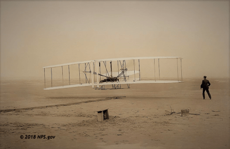
The aircraft lifted off for a 12 second, 120 foot flight!  Orville was able to bring the plane in for a somewhat controlled landing.  Wilbur then took the plane for a 12 second, 175 foot flight.  Orville followed with a 15 second, 200 foot flight.  The last flight of the day was by Wilbur; a 59 second, 852 foot flight.  That is almost the length of three football fields!  The plane landed hard and again broke the front elevator.  While bringing it back to the hanger, a gust of wind caught the plane and caused it to tumble end over end, which made repairs much more difficult.  They decided to call it a season, as they wanted to be back in Ohio for Christmas.  The plane was packed up, and sent back to Dayton, never to be flown again. Eventually, the restored plane made its way to the Smithsonian Institute in Washington, D.C. where it hangs from the ceiling today.  They continued improving upon their design, and eventually achieved their goal of selling planes to the military.

When Diana and I found our way to the Outer Banks of North Carolina this spring, we knew Kitty Hawk was one of the ‘must see’ destinations.  The National Park Service operates the site of the flights as the Wright Brothers National Memorial.

z2

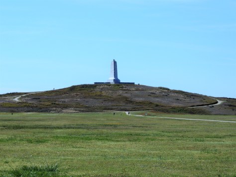
At the top of Big Kill Devil Hill, a large granite pillar is erected to signify their accomplishment.  Note that the area is completely covered in grass now, planted to keep the hill from shifting southward from the prevailing winds.

z3

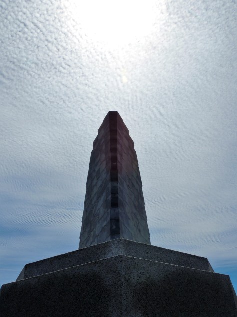
When we got to the front of the structure, we noticed the sun was positioned directly in line with it.  The clouds also had an interesting pattern to them, which we thought was neat.

z10

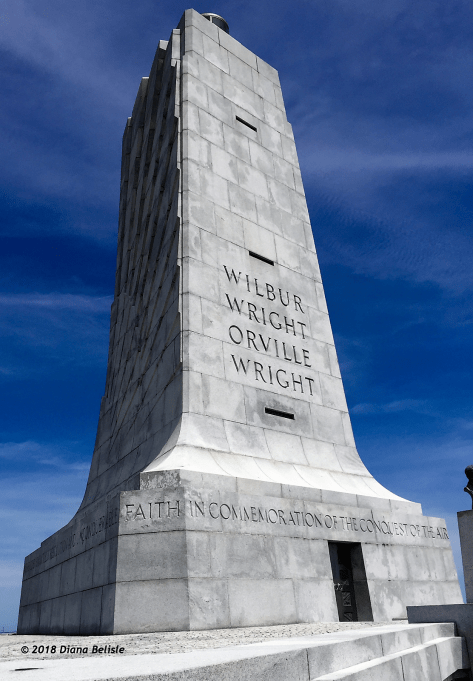
The size of the memorial is impressive, to say the least.  The inscription that is inscribed in the base reads  “In commemoration of the conquest of the air, by the brothers Wilbur and Orville Wright, conceived by genius, achieved by dauntless resolution and unconquerable faith.”

z1

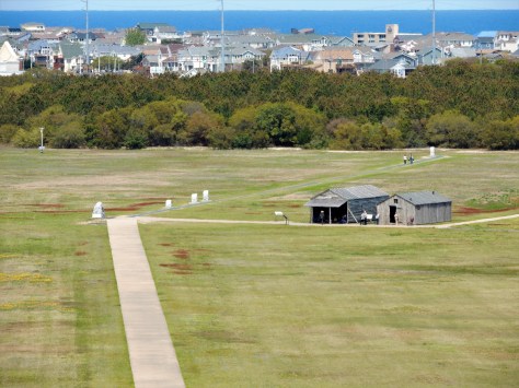
The view from the top shows the position of the hanger and their workshop and living quarters, along with the markers that signify the length of each flight.  In 1903, neither those houses in the distance nor trees were there.

z19

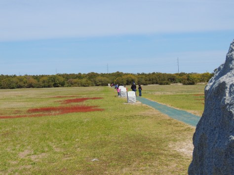
From the large granite marker at the end of the rail where they took off, a path runs along four smaller markers that signify the length of each flight.  Walking along it, I thought of all of the subsequent accomplishments in the 115 years since that day. All of us have been touched in one way or another by what happened at Kitty Hawk.

z5

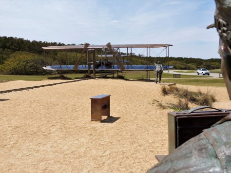
On the back side of Big Kill Devil Hill is an interactive sculpture of Orville’s first flight, shown here from the photographer’s point of view.

z6

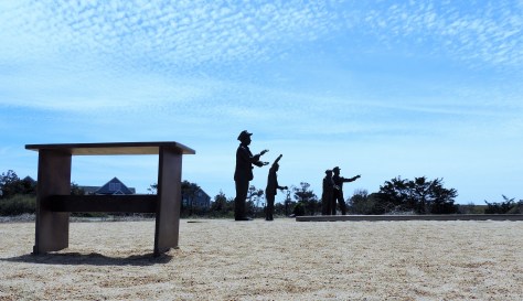
All of the men who were present for the event are depicted.  The second man from the right is a lumberman from Manteo who just happened to be at the lifesaving station when the Wrights signaled the crew to come over and help.

z7

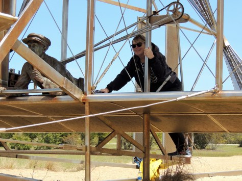
Visitors are encouraged to climb aboard the plane.  Diana and I took turns flying with Orville.  A fun way to end a perfect visit!

Stay tuned to see what else we find as we explore the rest of the Outer Banks in our next post.  Until then, safe travels!


Serendipity Along the Grand Strand

Have you ever been put somewhere by what seems like sheer luck?  Maybe it’s that, or maybe it’s meant to be.  We had that situation last May when we were put in a campsite next to a guy who I had a Facebook friend request into for ages, as we had 11 friends in common.  Turns out our now great friend Rick wasn’t big on checking his Facebook account.  🙂  Neither of us had any connectivity at the campground we were at on the Oregon coast, and our mutual friend Tracy (who figured out we were both there) was frantically trying to get in touch with us.  By the time she did, Rick had met us…even though we hadn’t made the mutual friends connection yet.  Thinking back, it was as if we were supposed to be there.

Such was the case on April 16th at Myrtle Beach State Park in South Carolina.  We really didn’t have any plans for what we were going to do once we got there, only that we wanted to see what the place known as the Grand Strand looked like.  We pulled in and got ourselves set up and prepared to settle in for the evening.  As I kicked back in my recliner, I could see a Bighorn fifth wheel passing by.  A few minutes later, I saw the back of it peeking out from behind the motorhome next door.  The woman that was helping direct the rig back looked really familiar to me.  I thought ‘Hmmmm….that looks like Sharon’, a fellow RV-Dreamer who we had yet to meet.  Before I could totally grasp that thought, her husband David popped into view.  Neither of us had any idea the other was going to be coming to Myrtle Beach. Here were two people that we had long wanted to get to know, placed just two campsites away from us.  We had been following their blog Two Lanes of Freedom for years, as they had with ours.  Dumb luck?  We choose to think it was more than that.  We were out of the rig and headed over to meet them in a flash!

They recognized us right away.  🙂  We talked for a bit and then called it a night, as we were all tuckered out from traveling. The next day, they invited us to go to Brookgreen Gardens with them, as they were meeting longtime RV-Dreamers, Bill and Nancy there.  Oh my goodness…two more people we had wanted to meet!

z4

Here we are gettin’ cozy on a park bench.  We slowly wound our way through Brookgreen’s trails, admiring the sculptures, landscaping, and animals.  All the while, we were learning more about each other.  🙂

z7

Here’s David admiring the gardens from the shade of a huge Live Oak tree.  Nancy and Sharon are in the background.

z6

This red fox had other plans for the lazy afternoon.

z9

Diana, Nancy, and Sharon are headed towards a sculpture of…

z8

Diana of the Chase.  This amazing work was created by Anna Hyatt Huntington in 1922.  She and her husband, Archer Huntington, founded Brookgreen in 1931 on four former rice plantations.  Close to 1500 works are displayed throughout the gardens.

z1

Their former winter home, Atalaya Castle, is located across US-17 in what is now known as Huntington Beach State Park.  Anna had an indoor and outdoor studio in the home.  She kept live animals in the courtyard, so she could study their muscle structure as they moved about.  What an amazing day with Bill, Nancy, David, and Sharon!

The next day was a beach day for Diana and I.  The temperature climbed above 80, which was perfect for putting our toes in the sand….except when the wind would shift and the cooler ocean air would roll in. David and Sharon stopped over for a bit, and we made plans for a campfire that evening.

z2

They were wondering who the couple was all bundled up on the beach, when they realized it was US!  Hey, our Michigan blood has thinned to a Florida viscosity.  🙂  That night we enjoyed a nice campfire and some excellent company, complete with several songs from David and his guitar.

The next morning was our travel day, but not before a sunrise meetup on the beach.

z5

I spotted them taking photos, so I took a few of my own.  We all headed back to camp, and Diana and I packed to leave. As we stopped by to say our farewells, David greeted us with his guitar.

z3

He sang us one of his ballads to see us on our way.  What a fitting and perfect ending to our time together.  Travel safely friends, we will see you down the road!


Charles Who?

As we were exploring Charleston, we kept coming upon a name that sounded familiar to us:  Charles Pinckney.  That was due in large part to our Michigan lineage, as there is a town in the Wolverine state named Pinckney.  I remember it well, as I did a 50 mile bicycle ride there one day with some friends.  After some research, it turns out that the South Carolina Pinckneys appear to not be related to the Michigan clan.  But who was this Charles Pinckney, and why does he have a national historic site in his honor?  Well, it turns out that there were several people by that name in Charleston.  In this post we are going to focus on the one who is honored at Charles Pinckney National Historic Site.

z2

Charles Pinckney (October 26, 1757 – October 29, 1824) came of age in a wealthy family as the people of the English colonies in America prepared to declare their independence from Britain. As a young man he fought in the Revolutionary War.  He was captured during the battle of Charleston and was taken prisoner until after the war ended.  Over his career, he was a four term Governor of South Carolina, a U.S. Senator, a U.S. Representative, and an ambassador to Spain.  But his biggest claim to fame was as a member of the Continental Congress when the U.S. Constitution was drafted.  On May 29, 1787, he submitted a plan to the convention that was called the Pinckney Draught.  It was similar in many ways to the Virginia Plan, calling for the following:

  • Three branches of government: Congress, Judicial and Executive branches.
  • A separate House and Senate.
  • A President shall inform Congress the conditions of the nation (State of the Union).
  • The President shall be Commander-in-Chief.
  • No state shall coin money, establish tariffs, keep troops, or enter into a treaty.
  • Only the House shall have the power of impeachment.

He also exclusively came up with the idea that no person should be held to a religious test to hold any elected office in the United States.

Eventually, ideas from all of the plans presented were woven into what became the United States Constitution.  Pinckney spoke often during the convention that was responsible for the creation of the instrument, and his signature is on the final document.

So how did his country plantation become a national historic site overseen by the National Park Service?  At first glance, the answer to that is a bit confusing…as the 1820’s era home that occupies the site was built by a subsequent owner.

z3

It turns out that the property had been sold to developers in the latter half of the 20th century.  Most of the original 715 acre estate was turned into a golf course, homes, and such.  US-17 even runs through it.  When the builders began to prepare the final 28 acres for development into 42 individual home sites, a group of local preservationists led by two women came to the rescue.  In 1986 they negotiated a $2 million purchase price, and proceeded to raise the money to cover it.  In 1990, they donated the property to the National Park Service.  The park opened to the public in 1995.

z4

The grounds are beautiful, with several paths winding through the property.  Over 150,000 artifacts have been unearthed from the site, along with the foundations from the original buildings.  The visitor center has many displays regarding Pinckney’s life of service, several of the found artifacts, and an interesting display on the Gullah culture along the lower Eastern seaboard.  Gullah is a language developed by the slaves that has an English base with West African influences.

z5

A fantastic example of the language is this Bible they have on display.  The English translation is on the sidebars.  I found it mesmerizing.  They actually let visitors page through it.

As with our other recent National Park visits, we completed our Junior Ranger books and earned our badges.  Having to search the displays for answers really makes sure we read each display carefully.  While the Charles Pinckney National Historic Site wasn’t a major attraction, we were glad we made the effort to go there.  We now have an appreciation for the man and his contributions to our nation.  As we see his name in the future, we will have a better understanding of who he was and where he came from.

Next up: A serendipitous assignment of campsites in Myrtle Beach.  Be sure to see the amazing meetup that resulted from that, and the friendships that came about as a result!  🙂

A Harbor Well Protected

Charleston Harbor is home to one of the most significant historic sites in the nation; Fort Sumter.  This massive brick structure at the entrance to the harbor saw the first shell of the Civil War explode above its walls. With that said, there are other historic military compounds around the perimeter of the harbor…each having significance in their own unique way.  Come on along as we tour these fascinating locations and find out the importance each one holds.  We even found a few surprises along our path!

Fort Sumter

z30
© moultrienews.com


Fort Sumter was not the first defense built in Charleston Harbor, but it was by far the most imposing.  Built in 1829, it was intended to defend against invaders coming in from the ocean. Able to fire cannons at three levels, it appeared to be invincible.  The Confederate states needed control of this fort, in order to bring supplies into Charleston and beyond. On April 12, 1861, Confederate Brigadier General P.G.T. Beauregard ordered his soldiers to fire upon the garrison that was held by Union Major Robert Anderson and 85 men under his command.  It was a difficult decision for Beauregard, as Anderson had been his artillery instructor at West Point.  The Union soldiers were not effective in hitting any Confederate targets, as the rebel forces were spread out around the large waterway.  The flip side of the coin was that Beauregard’s men had one thing to focus on, and they inflicted heavy damage.  When the Union soldiers called a truce on April 14, Fort Sumter had been heavily damaged.  Amazingly, no one had been killed in the battle on either side.

Once the Confederates held the structure, it was the Union’s turn to try to get it back.  Several attempts were made, but the South had a firm hold on it and the harbor.  Remember the building was tall, massive, and made of brick.  By 1865, the North had pounded it with seven million pounds of artillery shells. Most of that brick fell and created a solid mound of material that was stronger than the original fort. Only Sherman’s troops approaching on their March to the Sea, were enough to cause the Confederate troops to abandon the fort.

z3

Today’s structure bears little resemblance to the original.  The fallen brick has been cleared away and the lower portion of the walls are once again in view.  The black concrete battery in the center of the fort was completed in 1899, in preparation for the impending Spanish-American War.

z7

That battery was manned in both World Wars I & II, after which point the fort was decommissioned.

z4

Little remains of the lower level casemates.

z5

The older brick against the relatively newer concrete.

z6

This massive leaning wall was knocked off kilter when the powder magazine behind it accidentally exploded, killing 11 Confederate soldiers.  The National Park Service has installed these metal supports to prevent it from moving further.

Note that access to the island is by ferry boat, either from Liberty Square in Charleston or from Patriot’s Point in Mt. Pleasant.

z1

We chose the latter, which gave us this awesome bow view of the U.S.S. Yorktown aircraft carrier as we passed by!

Castle Pinkney

z8

Castle Pinkney sits in the center of the harbor, between Fort Sumter and Charleston.  Built in 1810, it was used for six weeks as a prisoner of war camp during the Civil War.  It also housed artillery, although it is believed that a hostile shot has never been fired from there.  In 1924 it was designated as a national monument, only to see that status taken away in 1951.  It was deemed excess property and sold to the South Carolina in 1958.  Attempts to turn it into a tourist attraction failed, so the state tried to give it back to the federal government.  They declined the offer. The Sons of Confederate Veterans took over care of the island, but were unable to raise the cash to buy it.  Finally, in 2011, the State of South Carolina sold Castle Pinckney to the Sons of Confederate Veterans for the sum of $10…in Confederate currency.  The Stars and Bars of the Confederacy fly over it today.

Fort Johnson

Fort Johnson was built in 1708.  Only a small powder magazine remains at the site that actually fired the first shot of the Civil War.  The rest of the site is occupied by South Carolina Fish and Wildlife and the College of Charleston.  It is unfortunate that this prominent place in American history wasn’t preserved.

Fort Moultrie

Last, but by no means least, is Fort Moultrie.  This location has the longest history of all the Charleston garrisons, having been manned for 171 years.

z2

Located on Sullivan’s Island, this was the second defensive structure built to protect Charleston.  Due to the natural curve in the river channel, ships had to pass here before they were ever within sight of town.  Soldiers would fire a cannon to notify the townsfolk of an approaching ship.  In 1776, a palmetto log fort was constructed by Colonel William Moultrie and his men to defend against a British invasion.  They fought a one day battle that heavily damaged the enemy ships, yet little damage was done to the fort.  Turns out that palmetto logs, a member of the cabbage family, are fibrous.  The British cannonballs simply bounced off.  To add insult to injury, the American soldiers would retrieve the balls and fire them back.

During the battle, the soldiers wore hats with a crescent. The shape had the word ‘Liberty’ inscribed in it.  This was also on South Carolina’s flag.  A palmetto tree was added to the flag at a later date to signify the palmetto logs of Fort Moultrie.

z12

That symbol is everywhere throughout the state.  Coffee mugs, keychains, license plates…you name it.  At first glance, we thought the flag represented a waning moon rising or setting over a palm tree.  The crescent represents a gorget, the throat plate that protected officers’ throats at that time.  In designing the flag, Colonel Moultrie chose the the crescent and blue color to match the uniforms they wore.  So much for that romantic image of an evening walk on a South Carolina beach with your sweetheart. 🙂

Between the Revolutionary and Civil wars, the fort continued to be manned.  It is interesting to note that a young private by the assumed name of Edgar A. Perry was stationed there from 1827 through 1828.  We know him as Edgar Allan Poe.  Fittingly, the establishment we ate at on the day of our tour of the fort was called Poe’s Tavern.

Another resident of the fort at that time was the famous Seminole leader, Osceola.  He was held there by the U.S. Army after being taken prisoner under a flag of truce in Florida.  In failing health, Osceola died there in 1838.

z9

His grave lies just outside the fort gate.  The John Anderson classic Seminole Wind came to mind as we stood there.  While it is sad that he isn’t buried in Florida, it is nice that he is given an honorable grave.  Also on the property is Colonel Moultrie’s grave, which is along the shore of the cove behind the visitor center.

At the beginning of the Civil War, Major Robert Anderson was originally garrisoned at Fort Moultrie.  By 1861, the walls had gone from palmetto to being made of brick.  However, the Union commander felt it was indefensible, as the area around it had been developed with homes that looked down into it. The Confederate army took over the post after Anderson and his men left for Fort Sumter.  Fort Moultrie had one of the best positions to shell Fort Sumter, with only a mile separating them.

Like Fort Sumter, Fort Moultrie had batteries built in the late 1800’s.

z14

These were used through World War II.  A gas and bombproof building was added following World War I.

z31

Referred to as HECP/HDCP, it was a joint command post run by the Army and Navy.  The building is maintained as a museum as it would have looked in the 1940’s.  It is interesting to note that German U-boats slipped past this post and mined Charleston’s harbor at different times in the war.

z11

We had a great time exploring the forts around Charleston this week.  We even earned two Junior Ranger badges in the process!  Stay tuned for one last adventure in Charleston, along with our move up the coast.  We hope you will tag along!


Charleston, South Carolina

We arrived in Charleston, South Carolina this past Monday without a plan as to what we were going to be seeing.  Sure, we knew that this was the location of Fort Sumter, the place that received the first shot of the Civil War.  Beyond that, we knew little of Charleston’s story.  By pure luck, we opted to stay at the same KOA that our friend Kathy was working at.

z1

You may recall that we had met her while working at Amazon, and we also caught up with her in the Black Hills last September.  On this occasion, she was heading out the following day to her next KOA gig in New York…one we are staying at later in our trip.  We went out to a local pizzeria and she filled us in on a few things to see in town.

On Wednesday, our friends from Melbourne Beach Mobile Park, Brenda and Jim, met us in Charleston’s historic district.

z2

Brenda’s blog, No More Sticks and Bricks, details their journey as fulltime RVers.  Definitely check it out.  The four of us had lunch at the Brown Dog Deli, then we set out to do some exploring!

z15

All throughout the town, we saw these plates with nuts in the center of them.  They are called earthquake bolts, and they were put there following the 7.0 quake in 1886 that rocked the city.  They are rods that run completely through the buildings that help straighten the bulging walls.

z11

This is St. Michael’s Episcopal Church.  It is the oldest religious structure in Charleston, dating back to the 1750’s.   It’s graveyard  holds two of the signers of the U.S. Constitution: John Rutledge and Charles Pinckney.

z17

Both George Washington and Robert E. Lee attended services here, each sitting in Pew #43, some 70 years apart.

z14

On State Street, we found the Union Insurance building.  Back in the day, each insurance company in town also had their own fire truck.  See that seal at the top of the building?  Each insured home displayed the seal from the company they were insured by.  While all companies would respond to a fire, only the one that insured the home was responsible to fight the blaze.

z10

Jim, Brenda and Diana are admiring the Heyward-Washington house.  Thomas Heyward, signer of the Declaration of Independence, owned this home.  George Washington stayed here on his visit to the city in 1791.

z5

Twice we passed by St. Phillip’s Episcopal Church, but were unable to view the interior.  The first time, a funeral was in progress and the second time it was closed.  This building was built in the 1830’s, after fire destroyed its predecessor.  In 1861, the bells in the steeple were donated to the Confederate Army to be made into munitions.  They were not replaced until 1976.

z16

On Bay Street is this collection of houses known as Rainbow Row.  Alternating pastel colors adorn each home.  This concludes our tour of the upper part of town with Jim and Brenda.  What a fun day!

On Friday, Diana and I decided to check out the lower portion of the historic district.

z13

This beautiful building is the Circular Congregational Church.  Part of the United Church of Christ, this progressive congregation has been meeting at this site since 1681.  The current building was built after the earthquake.

z18

We also saw several of these ‘single’ houses, meaning they were only one room wide.  This allowed the sea breezes to flow through the homes.  Note the front door.  It actually opens to the porch, thereby allowing privacy for the homeowners when they were sitting outside.

z19

Overlooking the harbor is the High Battery.  Named for the artillery that was mounted there during the Civil War, this raised walkway allowed for the construction of lower Bay Street.

z20

One of the many homes across from the High Battery is the Edmondston-Alston house.  It is from the second floor porch that Confederate General P.G.T. Beauregard observed the shelling of Fort Sumter, which can be easily seen from that vantage point.

z7

Further down the street is this monument to the men of the Confederacy.  The figures are looking directly across the harbor at Fort Sumter.

z6

White Point Garden sits at the extreme south end of town.  The beautiful park has a checkered past, as Stede Bonnet and 50 of his fellow pirates were hung here in 1791.  They were left hanging for days as a successful deterrent to piracy along these shores.  It was also the site of heavy artillery during the Civil War.

z12

That wraps up our tour of the historic district in Charleston.  Next up is a tour of Forts Sumter and Fort Moultrie, both including some surprises found there that we weren’t aware of.  Be sure to stay tuned for that adventure in our next post!


Tybee Island Light and the Mighty Eighth

Before we take the trip up the coast as we promised in our last post, we wanted to detail two other notable sites we toured in Savannah:  Tybee Island Light Station and The National Museum of the Mighty Eighth Air Force.  The former has guided mariners in some shape or form along the Georgia shore for almost 300 years.  The latter honors the men and women who served and are serving in the Eighth Air Force, which was founded in Savannah in 1942.

Tybee Island Light Station

We will begin with the Tybee Island Light Station.  First ordered by General James Oglethorpe back in 1732, the beacon started its career as a simple day-mark; in other words, there wasn’t a light associated with it. The octagonal brick structure stood ninety feet tall.  Unfortunately, it was built too close to the shore and storms destroyed it in 1741.  The next year, a slightly taller day-mark was built, this time with a flagpole on top.  Even though this one was further away from the shore, the sea eventually reached the tower.  A third tower was completed in 1773.  That tower was 60 feet of brick, topped with 40 feet of wood.  In 1791, a light was added to the day-mark.

When the Confederate troops abandoned Tybee Island in 1861, they burned the wooden portion of the beacon to prevent Union soldiers from using it.  After the war, the tower was increased in size to it’s current height, using the original 60 foot brick tower as it’s base.

z9

That is what we see today.  Currently standing at 145 feet, it is the tallest lighthouse in Georgia.  There are 178 steps that take visitors to the top to view the fixed first order Fresnel lens.

z10

Having climbed it, we have serious respect for the men who kept the light burning.  As we were waiting to enter, an older Southern gentleman exited, looked at the ticket-taker and said ” If I win the lottery, I am gonna take a whole bunch of that money and build y’all an elevator to the top of that thing!”  We all got a good laugh out of that.  🙂

The rest of the station’s buildings are intact and restored with period furnishings.

z11

We toured the head keeper’s house, which was built in 1881.

z21

One thing we found unique was the tongue-in-groove southern pine walls and ceilings. They really gave the home a warm, cozy feel.

National Museum of the Mighty Eighth Air Force

The other highlight of this trip to Savannah was the National Museum of the Mighty Eighth Air Force.

This division of the military currently consists of over 16,000 personnel whose primary mission is to keep America safe by operating and maintaining our long-range bombers.  They were established in 1942 with the same goal in mind.  Back then, they flew B-17 and B-24 bombers out of approximately 100 bases in England on daylight runs over Nazi Germany.  They also provided fighter escort for those big planes.

z10

The museum has a gorgeous B-17 Flying Fortress as its centerpiece.  On any given day, hundreds of these planes would be in the air.  One day in early 1944, Jimmy Doolittle led over 1,000 B-17’s across Europe to bomb Berlin.  It is difficult to imagine the sheer terror that must have existed on the ground that day.  At that time this division of the Army Air Corps had 200,000 people in their ranks, and had the capability of putting 3,000 bombers and fighters in the air on any given day…hence, the ‘Mighty’ as a prefix.

As we toured this building, the story of the Mighty Eighth was detailed through photos, videos, and displays.  As far as military museums go, this was what I would consider one of the better ones…as it personalized the war.  Stories from both sides were told along the way, making for a compelling afternoon.

z1

One such story was of the plane “Snap, Crackle, and Pop”.  The pilot of this plane, depicted in a mural at the museum, was from Battle Creek, Michigan, home of Kellogg’s Cereal.  He received permission, before flying the plane to England, to stop home and have one of the company artists paint the Rice Krispies trio on the front of the plane. Sometime later in the war, the B-17 was shot down over France, and only two parachutes were seen exiting the aircraft.

z8

Actually the ball turret gunner, a man by the name of Alan Magee, also got out of the plane…but without his parachute.  You see, this position in the B-17 is so small, the gunner would have to leave his parachute above him in the fuselage.  By the time he got to it, the bomber was disintegrating and he was thrown clear.  He fell 20,000 feet and crashed through the glass roof of the railroad station in St. Nazaire, France.  A German doctor saved his life by doing surgery on his many injuries.  The surgeon told him, “I am a doctor first, and a German second.”  Magee lived to be 84 years old.

z4

There was also a reminder of a story my father told me when he learned to fly in one of these Stearman trainers during the war.  His instructor told him to do a ‘carrier landing’, which was to put the tail wheel on the ground before the front wheels.  The maneuver simulated what a pilot would do on an aircraft carrier when they put their tail hook low enough to grab the cable on the deck.

z5

The tail wheel hit the runway hard and smashed the entire assembly up into the plane.  When Dad saw the damage, he feared he had totally screwed up. The instructor looked at him and said “Perfect!”  🙂

The exhibits also included stories of the Tuskegee Airmen, and the WASP’s…the non-combat women pilots who delivered planes to bases during the war.

z7

One of those women was Suzanne Parish.  She and her husband started the Air Zoo in Kalamazoo, Michigan.  Back when I was in college, I would see her buzzing over campus in her pink P-40 Warhawk.  Little did I know at the time of her invaluable service during the war.  If you want to read more about the Air Zoo and see a photo of her beloved pink aircraft, follow this link.

That wraps up our tour of Savannah, Georgia for this year.  We are sure to be back, as we left so much to discover on a future trip.  Next up: Charleston, South Carolina.  We hope you tag along to see what we find there!

Fort Pulaski

On the east end of Cockspur Island, in the middle of the Savannah River, sits one of the most massive brick fortifications ever built; Fort Pulaski.  This impressive structure was named for Count Casimir Pulaski, a Polish soldier who fought in the American Revolution and lost his life during the Battle of Savannah in 1779.  It was constructed over an 18 year period beginning in 1829, and sits on the Georgia side of the border with South Carolina. Sporting 7-1/2 foot thick walls that tower 32 feet above the 8 foot deep moat, it was felt that the structure was impenetrable.

z15

It was part of a coastal defense system put into place by President James Madison after the War of 1812.

z20

It is interesting to note that preliminary construction of the fort…including the canal system seen above…was the first assignment for a young cadet fresh out of West Point by the name of Robert E. Lee.  He was here from 1829 until 1831.

Even though it was completed in 1847, Fort Pulaski had not yet been manned by the army, nor was it fully gunned by the time 1860 rolled around.  On January 3, 1861, Georgia governor Joseph E. Brown ordered the state militia to occupy the fort.  This was in response to federal troops seizing Fort Sumter to the north at Charleston just two weeks earlier, after South Carolina voted to secede from the Union.  Savannah was an important port for the southern states, and vital to the success of the Confederacy.

z16

Work began in earnest to ready the post for the battle that was sure to come.  Thick timbers, such as can be seen in the photo above, were leaned against the inner walls.  This allowed a protected passageway between the casemates that surrounded the perimeter.

z14

Within a year, Union troops were setting up a series of 11 batteries on nearby Tybee Island, just to the southeast.  Those positions are signified in red in the above photo.  With the south and southeast walls of the fort (noted in green) at more than a mile away, it was felt by the Confederates that they were safe from anything the Union army could lob at them from that distance.  What they did not know was that the Federal troops had a new weapon: the 30 pound Parrott rifled cannon.  This gun had spiraled grooves the length of its bore which increase the accuracy and velocity of its 30 pound bullet-shaped projectiles.  This gun had a range of nearly five miles, so breaching Fort Pulaski’s walls at a mere mile away was a fairly easy task.  There were five of these guns in the Union’s arsenal on Tybee’s shore, along with five smaller rifled guns and twenty-six mortars.

z2

On April 10, 1862, Captain Quincy A. Gilmore sent a boat to Cockspur under the flag of truce to demand the confederates surrender the fort.  That demand was refused, so Gilmore ordered his men to open fire. Thirty hours and over five thousand shells later, the Union army opened a hole in the southeast corner of the fort.  The area that was destroyed was reconstructed and can be seen above as darker red brick.  The rest of the garrison walls still show the damage to this day.  Fearing that his powder magazines would be breached and the entire fort would be destroyed by the resulting explosion, Confederate Col. Charles H. Olmstead surrendered.  Similar to the unsinkable Titanic that sank almost 50 years to the day later, this impenetrable fort was penetrated.  Needless to say, confederate leaders were shocked.

z4

Visitors today can still see some of the shells embedded in the walls, the backs of which all face northeast.

z3

Even the tip of the southeastern-most cannon was damaged in the battle.

z12

This is the view the Union soldiers had from Tybee Island, about one mile from the garrison’s southeast flank.

z13

Amazingly, little Cockspur Island Lighthouse received hardly any damage during the siege, even though it was in the direct line of fire.  It is still standing strong.  It was re-lit in 2007 for historical purposes.

The 30 hour battle at Fort Pulaski rendered brick fortifications obsolete.  Union troops repaired the hole in the outer walls and turned the structure into a prison until the end of the war.  It was here that the Immortal Six Hundred…Confederate prisoners who refused to take an oath of allegiance to the United States…were held under horrible conditions. Thirteen of them died there and were buried along the outside bank of the moat. By 1880, only a lighthouse keeper and a caretaker remained.  They too were soon gone, and the fort was left to the forces of nature.  In 1924, Fort Pulaski was made a national monument, with restoration efforts taking place during the Great Depression.

z17

We learned a lot from our visit to Fort Pulaski, all while each adding a Junior Ranger badge to our collection.  If there is one important takeaway from this monument, it is the fact that no one is invincible.

Stay tuned to see what we find as we explore further up the coast.  Until next time, safe travels!

Scouting Savannah


Written by Diana
 .
We left Brunswick, Georgia, Sunday morning and traveled 216 miles to see Rick from On the Road with Maxine and Me. He is a fellow RV-Dreamer that we met while volunteering at Heceta Head Lighthouse in Oregon last summer. We have been lucky to see him twice since then, but we couldn’t pass up a chance for another visit since we were relatively close.
 .
Rick Diana Jim
.
Rick spent this past winter volunteering for Georgia State Parks at Hamburg State Outdoor Recreation Area. We had a lovely site right on the water, and it was easy to see why he enjoyed his time at this beautiful campground.
.
OLYMPUS DIGITAL CAMERA
.
 This photo was taken from the lake. The guys did a lot of pedaling on the paddle boat to get this photo for me!
.
Dogwood Rick
.
The Dogwoods were in bloom, and the spring green leaves were amazing!
.
Jim Maxine
.
 It was great to see Maxine too!
.
sunrise fog Rick
.
We enjoyed our morning coffee while watching the fog roll across the lake and this beautiful sunrise. It was hard to leave here after only one night. Not sure when it will be, but we look forward to seeing Rick and Maxine … down the road.
.
Tuesday night we arrived at a Boondockers Welcome site that is located about a half hour west of Savannah. This host has room for four rigs, and we appreciate the opportunity to stay here four nights while we visit the area.
.
birthplace outside
.
Tuesday we headed into Savannah’s historic district. We had purchased tickets online to visit the Juliette Gordon Low Birthplace. Known as Daisy, the founder of Girl Scouts in the U.S.A. was born here in 1860. I was thrilled to be at the home I had seen so many time in photos, and the tour did not disappoint.
 .
Diana Juliette 2
.
Scouting was a huge part of my childhood, and I really enjoyed learning more about this strong women who started an organization that has meant so much to so many.
.
girls birthplace
.
It was really fun to see the numerous Girl Scout troops that were visiting during their spring breaks, and to share in their enthusiasm for scouting.
.
Gordon statue2
.
After lunch we visited Wright Square, one of the many squares (parks) that make the city so unique. Wright Square has the Gordon Monument which honors William Washington Gordon. In addition to being Juliette’s grandfather, he was an early mayor of Savannah and founder of the Central Railroad and Banking Company of Georgia.
.
low front house
.
Then we toured the Andrew Low House. This beautiful home is where Juliette lived after her marriage to William Mackay Low in 1886. After his death, she continued to live in the home until she died in 1927 at the age of 66. It was during this time, at the age of 51, that she established the Girl Scouts of America.
.
hill
.
From the Low House, we headed down to River Street.  The ramped streets that connect it to the upper town are paved with cobblestones.  Those stones were ballast from 19th century ships and are from ports throughout the world.
 .
Jim waving girl
.
On River Street, we visited the Waving Girl statue.  This is a monument to Florence Martus, a lifelong resident of the area. From 1887 to 1931, she waved at every single ship that entered and left the port, either with her handkerchief or with a lit lantern at night.  We had read about her several years ago, and we wanted to make sure we saw this memorial to her.
.
There is so much history to enjoy in Savannah, but Jim ended up treating me to a day filled mostly with scouting history. Stay tuned for our next post when we will be back in his wheelhouse, as we plan to explore Tybee Island and Ft. Pulaski tomorrow.
 .
once a gs


Jekyll and St. Simons Islands

When we left you last, we had explored northern Florida in an area that had been contested by the French and the Spanish back in the 1500’s.  On Thursday, we moved a mere 70 miles up the road to Brunswick, Georgia.  Here we found stories of the pre-Revolutionary British, the Civil War, the early 20th Century elite, and modern day foreign trade.  With only a few days here it was not only a lot to discover, but it was hard to keep it all straight!

We began by pulling into our first Boondockers Welcome location.  This is a program where people allow you to camp on their property for free.  This particular location was hosted by Leslie and Skipper, and they were just super to us.  We even hung out with them one evening around their fire pit, and got to know them and their neighbors over cocktails.  To show our appreciation for their hospitality, we gave them a small gift bag with some goodies from Michigan.  🙂

z14

They lost several trees during Hurricane Irma.  Fortunately, they all fell across the driveway when no one was home.  Thank you again, Leslie and Skipper!

On Friday, we headed out to St. Simons Island.  This particular barrier island is home to Fort Fredrica, an 18th Century British outpost and townsite.  The settlement was put into place under the watchful eye of James Oglethorpe; a soldier, member of Parliament, and a visionary.  His plan was to establish somewhat of a Utopia for people in debtors prisons back in England, all the while creating a buffer between British colonies to the north and the Spanish to the south.  A fort was erected along the Altamaha River in 1734, and a fortified town was laid out just behind it.  There were 84 lots, most of which were 60 by 90 feet.  Each family also received 50 acres in the surrounding countryside to raise crops.  As the town began to spring up, the Spanish to the south took notice.  Sensing the rising tensions, Oglethorpe sailed back to England and brought back a regimen of over 600 soldiers.  In 1740, the British went on the offensive and set sail for St. Augustine.  The ships bombarded the Spanish fort for two weeks straight to no avail.  Details as to just why that was, can be viewed in our post on St. Augustine by clicking here.  The British headed back to Fredrica and the Spanish followed not too long afterwards.  They brought an army of 2000 men with the intention of taking the fort and town.  Unfortunately for them, the British were more familiar with the area and their troops and townsfolk  used guerrilla tactics to chase the Spanish soldiers back south.  Without too much bloodshed, the skirmish ended and order was restored.

z8

When we arrived we requested our Junior Ranger materials, and enjoyed the movie and displays in the visitor’s center. Not letting the fairly steady rain deter us, we headed out through the town-site to the fort.  The river has changed course, so much of the location of the fort is now underwater. A couple of magazines remain above ground. The foundations of many structures have been unearthed by extensive archaeological studies, including the storehouse which John Wesley lived above.  We were able to make out the earthen berms that were the base of the fort’s walls, as well as footings of many of the homes.

z11

The town’s streets were well marked, as were each of the foundations.  After we received our badges, we went to explore the rest of the island.

Across from the fort is this monument and memorial garden to John and Charles Wesley.

z3

John Wesley is the founder of the Methodist Church. Diana is United Methodist and was pretty excited to walk the same ground as John Wesley, especially on Good Friday.  He made five separate trips to Fredica from England in 1736 and 1737.  It was after leaving Georgia for the last time that he began the Methodist Church.  There is a large Methodist conference center and museum on the island.  We drove around the beautiful campus, but were too late to tour the museum.

We also visited the St. Simons Lighthouse.

z6

This impressive structure looked very familiar to us.  It turns out that the engineer responsible for it was a man named Orlando Metcalfe Poe.  He was General Sherman’s chief engineer who accompanied him on his March to the Sea near the end of the Civil War.  After the war, Poe became the chief engineer of the U.S. Lighthouse Service. He developed this style of lighthouse and St. Simons was constructed in 1872.  Just prior to that, Poe was promoted to become the Great Lakes lighthouse chief engineer, as the region’s burgeoning shipping industry required sentinels to keep them safe.  He oversaw the construction of 8 lighthouses on the Great Lakes that used this same design.  He also designed the first of the Soo Locks, which was named after him.  He was injured during its construction and died of a subsequent infection in Detroit shortly afterwards.  He is buried in Arlington National Cemetery. His lock, which he never saw completed, was totally rebuilt in the 1960’s to allow 1000 foot freighters to pass between Lake Superior and the lower lakes.  They kept his name on it. 🙂

z5

The view from the top is outstanding!  The original 3rd order Fresnel lens is still in use.

While we were at the top of the tower, we asked a local woman about the ships pictured above.  Brunswick is home to a huge port that deals with ‘roll off-roll on’ cargo, in other words…vehicles.

z7

This is a screenshot of the port from Google Maps.  The five rows in the area circled in red contains over 3000 cars and trucks.  Considering all the other vehicles in the lots, there has to be well over 50,000 of them there!  We saw several of those ships coming and going while we were in Brunswick, so they must really employ a lot of people to move those cars.

On Saturday, we made our way to Jekyll Island for a bike ride.  We had scoped it out on Thursday evening, and we found the paths on the island to be favorable for our TerraTrikes.

z1

That day, we visited Driftwood Beach.  In the photo, I am looking across the water at St. Simons lighthouse.

z2

We also toured the historic district that was established in the late 1800’s.  The Jekyll Island Club attracted the wealthy elite; names like Rockefeller, Morgan, and Vanderbilt.

z4

Here is the Rockefeller ‘cottage’.  🙂

So on our return trip, we set out to circle most of the island.

z13

We rode through the historic district…

z10

…over the marshes…

z12

…and along the seashore.  It was good to be back on the trikes!

That wraps up our time in Brunswick.  Our next destination is Savannah, but not before a quick stop to see a good friend.  Stay tuned for that adventure!  Until then, safe travels to all.