Category Archives: Georgia

Tybee Island Light and the Mighty Eighth

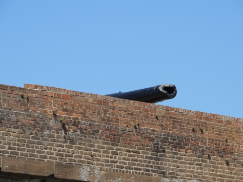
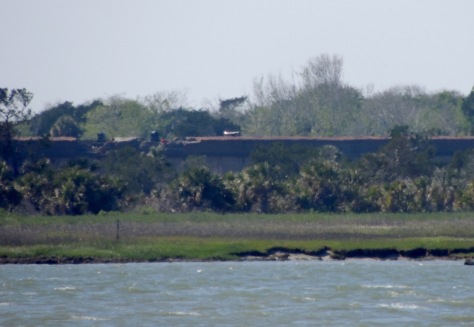
Before we take the trip up the coast as we promised in our last post, we wanted to detail two other notable sites we toured in Savannah:  Tybee Island Light Station and The National Museum of the Mighty Eighth Air Force.  The former has guided mariners in some shape or form along the Georgia shore for almost 300 years.  The latter honors the men and women who served and are serving in the Eighth Air Force, which was founded in Savannah in 1942.

Tybee Island Light Station

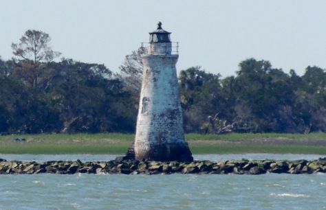
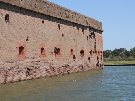
We will begin with the Tybee Island Light Station.  First ordered by General James Oglethorpe back in 1732, the beacon started its career as a simple day-mark; in other words, there wasn’t a light associated with it. The octagonal brick structure stood ninety feet tall.  Unfortunately, it was built too close to the shore and storms destroyed it in 1741.  The next year, a slightly taller day-mark was built, this time with a flagpole on top.  Even though this one was further away from the shore, the sea eventually reached the tower.  A third tower was completed in 1773.  That tower was 60 feet of brick, topped with 40 feet of wood.  In 1791, a light was added to the day-mark.

When the Confederate troops abandoned Tybee Island in 1861, they burned the wooden portion of the beacon to prevent Union soldiers from using it.  After the war, the tower was increased in size to it’s current height, using the original 60 foot brick tower as it’s base.

z9

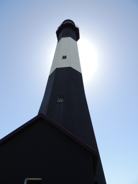
That is what we see today.  Currently standing at 145 feet, it is the tallest lighthouse in Georgia.  There are 178 steps that take visitors to the top to view the fixed first order Fresnel lens.

z10

Having climbed it, we have serious respect for the men who kept the light burning.  As we were waiting to enter, an older Southern gentleman exited, looked at the ticket-taker and said ” If I win the lottery, I am gonna take a whole bunch of that money and build y’all an elevator to the top of that thing!”  We all got a good laugh out of that.  🙂

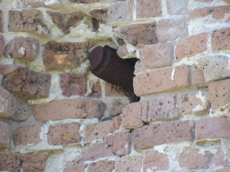
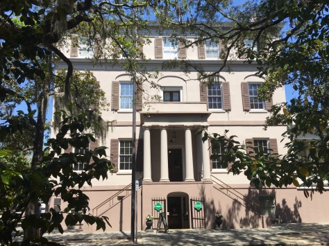
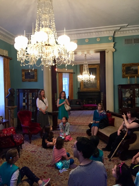
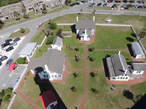
The rest of the station’s buildings are intact and restored with period furnishings.

z11

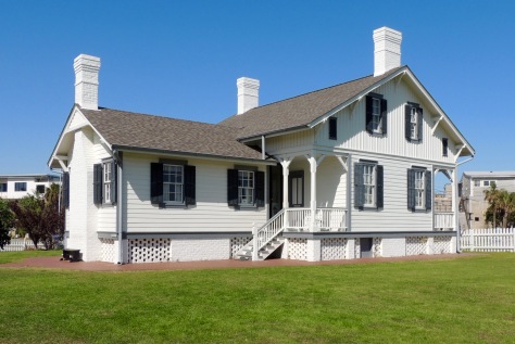
We toured the head keeper’s house, which was built in 1881.

z21

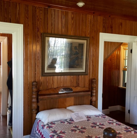
One thing we found unique was the tongue-in-groove southern pine walls and ceilings. They really gave the home a warm, cozy feel.

National Museum of the Mighty Eighth Air Force

The other highlight of this trip to Savannah was the National Museum of the Mighty Eighth Air Force.

This division of the military currently consists of over 16,000 personnel whose primary mission is to keep America safe by operating and maintaining our long-range bombers.  They were established in 1942 with the same goal in mind.  Back then, they flew B-17 and B-24 bombers out of approximately 100 bases in England on daylight runs over Nazi Germany.  They also provided fighter escort for those big planes.

z10

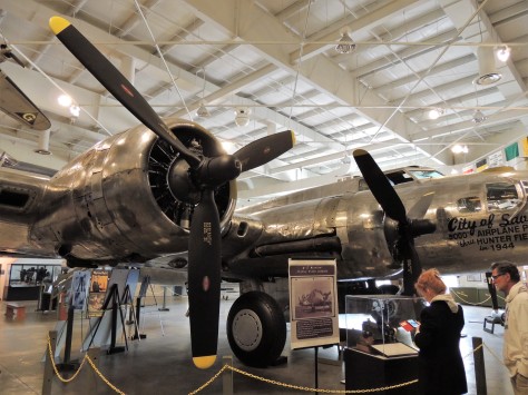
The museum has a gorgeous B-17 Flying Fortress as its centerpiece.  On any given day, hundreds of these planes would be in the air.  One day in early 1944, Jimmy Doolittle led over 1,000 B-17’s across Europe to bomb Berlin.  It is difficult to imagine the sheer terror that must have existed on the ground that day.  At that time this division of the Army Air Corps had 200,000 people in their ranks, and had the capability of putting 3,000 bombers and fighters in the air on any given day…hence, the ‘Mighty’ as a prefix.

As we toured this building, the story of the Mighty Eighth was detailed through photos, videos, and displays.  As far as military museums go, this was what I would consider one of the better ones…as it personalized the war.  Stories from both sides were told along the way, making for a compelling afternoon.

z1

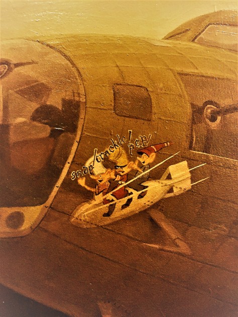
One such story was of the plane “Snap, Crackle, and Pop”.  The pilot of this plane, depicted in a mural at the museum, was from Battle Creek, Michigan, home of Kellogg’s Cereal.  He received permission, before flying the plane to England, to stop home and have one of the company artists paint the Rice Krispies trio on the front of the plane. Sometime later in the war, the B-17 was shot down over France, and only two parachutes were seen exiting the aircraft.

z8

Actually the ball turret gunner, a man by the name of Alan Magee, also got out of the plane…but without his parachute.  You see, this position in the B-17 is so small, the gunner would have to leave his parachute above him in the fuselage.  By the time he got to it, the bomber was disintegrating and he was thrown clear.  He fell 20,000 feet and crashed through the glass roof of the railroad station in St. Nazaire, France.  A German doctor saved his life by doing surgery on his many injuries.  The surgeon told him, “I am a doctor first, and a German second.”  Magee lived to be 84 years old.

z4

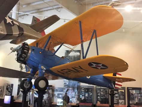
There was also a reminder of a story my father told me when he learned to fly in one of these Stearman trainers during the war.  His instructor told him to do a ‘carrier landing’, which was to put the tail wheel on the ground before the front wheels.  The maneuver simulated what a pilot would do on an aircraft carrier when they put their tail hook low enough to grab the cable on the deck.

z5

The tail wheel hit the runway hard and smashed the entire assembly up into the plane.  When Dad saw the damage, he feared he had totally screwed up. The instructor looked at him and said “Perfect!”  🙂

The exhibits also included stories of the Tuskegee Airmen, and the WASP’s…the non-combat women pilots who delivered planes to bases during the war.

z7

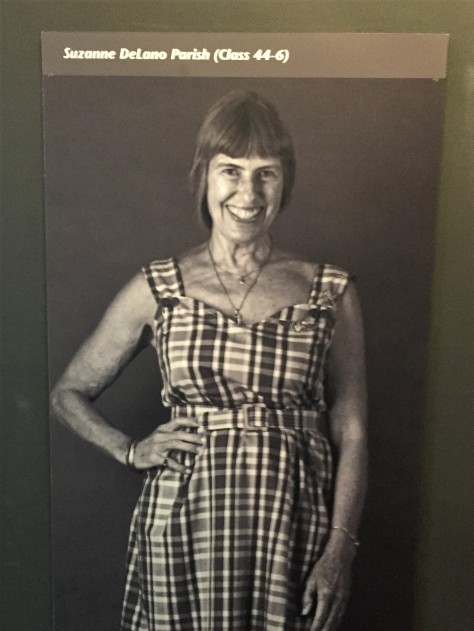
One of those women was Suzanne Parish.  She and her husband started the Air Zoo in Kalamazoo, Michigan.  Back when I was in college, I would see her buzzing over campus in her pink P-40 Warhawk.  Little did I know at the time of her invaluable service during the war.  If you want to read more about the Air Zoo and see a photo of her beloved pink aircraft, follow this link.

That wraps up our tour of Savannah, Georgia for this year.  We are sure to be back, as we left so much to discover on a future trip.  Next up: Charleston, South Carolina.  We hope you tag along to see what we find there!

Fort Pulaski

On the east end of Cockspur Island, in the middle of the Savannah River, sits one of the most massive brick fortifications ever built; Fort Pulaski.  This impressive structure was named for Count Casimir Pulaski, a Polish soldier who fought in the American Revolution and lost his life during the Battle of Savannah in 1779.  It was constructed over an 18 year period beginning in 1829, and sits on the Georgia side of the border with South Carolina. Sporting 7-1/2 foot thick walls that tower 32 feet above the 8 foot deep moat, it was felt that the structure was impenetrable.

z15

It was part of a coastal defense system put into place by President James Madison after the War of 1812.

z20

It is interesting to note that preliminary construction of the fort…including the canal system seen above…was the first assignment for a young cadet fresh out of West Point by the name of Robert E. Lee.  He was here from 1829 until 1831.

Even though it was completed in 1847, Fort Pulaski had not yet been manned by the army, nor was it fully gunned by the time 1860 rolled around.  On January 3, 1861, Georgia governor Joseph E. Brown ordered the state militia to occupy the fort.  This was in response to federal troops seizing Fort Sumter to the north at Charleston just two weeks earlier, after South Carolina voted to secede from the Union.  Savannah was an important port for the southern states, and vital to the success of the Confederacy.

z16

Work began in earnest to ready the post for the battle that was sure to come.  Thick timbers, such as can be seen in the photo above, were leaned against the inner walls.  This allowed a protected passageway between the casemates that surrounded the perimeter.

z14

Within a year, Union troops were setting up a series of 11 batteries on nearby Tybee Island, just to the southeast.  Those positions are signified in red in the above photo.  With the south and southeast walls of the fort (noted in green) at more than a mile away, it was felt by the Confederates that they were safe from anything the Union army could lob at them from that distance.  What they did not know was that the Federal troops had a new weapon: the 30 pound Parrott rifled cannon.  This gun had spiraled grooves the length of its bore which increase the accuracy and velocity of its 30 pound bullet-shaped projectiles.  This gun had a range of nearly five miles, so breaching Fort Pulaski’s walls at a mere mile away was a fairly easy task.  There were five of these guns in the Union’s arsenal on Tybee’s shore, along with five smaller rifled guns and twenty-six mortars.

z2

On April 10, 1862, Captain Quincy A. Gilmore sent a boat to Cockspur under the flag of truce to demand the confederates surrender the fort.  That demand was refused, so Gilmore ordered his men to open fire. Thirty hours and over five thousand shells later, the Union army opened a hole in the southeast corner of the fort.  The area that was destroyed was reconstructed and can be seen above as darker red brick.  The rest of the garrison walls still show the damage to this day.  Fearing that his powder magazines would be breached and the entire fort would be destroyed by the resulting explosion, Confederate Col. Charles H. Olmstead surrendered.  Similar to the unsinkable Titanic that sank almost 50 years to the day later, this impenetrable fort was penetrated.  Needless to say, confederate leaders were shocked.

z4

Visitors today can still see some of the shells embedded in the walls, the backs of which all face northeast.

z3

Even the tip of the southeastern-most cannon was damaged in the battle.

z12

This is the view the Union soldiers had from Tybee Island, about one mile from the garrison’s southeast flank.

z13

Amazingly, little Cockspur Island Lighthouse received hardly any damage during the siege, even though it was in the direct line of fire.  It is still standing strong.  It was re-lit in 2007 for historical purposes.

The 30 hour battle at Fort Pulaski rendered brick fortifications obsolete.  Union troops repaired the hole in the outer walls and turned the structure into a prison until the end of the war.  It was here that the Immortal Six Hundred…Confederate prisoners who refused to take an oath of allegiance to the United States…were held under horrible conditions. Thirteen of them died there and were buried along the outside bank of the moat. By 1880, only a lighthouse keeper and a caretaker remained.  They too were soon gone, and the fort was left to the forces of nature.  In 1924, Fort Pulaski was made a national monument, with restoration efforts taking place during the Great Depression.

z17

We learned a lot from our visit to Fort Pulaski, all while each adding a Junior Ranger badge to our collection.  If there is one important takeaway from this monument, it is the fact that no one is invincible.

Stay tuned to see what we find as we explore further up the coast.  Until next time, safe travels!

Scouting Savannah


Written by Diana
 .
We left Brunswick, Georgia, Sunday morning and traveled 216 miles to see Rick from On the Road with Maxine and Me. He is a fellow RV-Dreamer that we met while volunteering at Heceta Head Lighthouse in Oregon last summer. We have been lucky to see him twice since then, but we couldn’t pass up a chance for another visit since we were relatively close.
 .
Rick Diana Jim
.
Rick spent this past winter volunteering for Georgia State Parks at Hamburg State Outdoor Recreation Area. We had a lovely site right on the water, and it was easy to see why he enjoyed his time at this beautiful campground.
.
OLYMPUS DIGITAL CAMERA
.
 This photo was taken from the lake. The guys did a lot of pedaling on the paddle boat to get this photo for me!
.
Dogwood Rick
.
The Dogwoods were in bloom, and the spring green leaves were amazing!
.
Jim Maxine
.
 It was great to see Maxine too!
.
sunrise fog Rick
.
We enjoyed our morning coffee while watching the fog roll across the lake and this beautiful sunrise. It was hard to leave here after only one night. Not sure when it will be, but we look forward to seeing Rick and Maxine … down the road.
.
Tuesday night we arrived at a Boondockers Welcome site that is located about a half hour west of Savannah. This host has room for four rigs, and we appreciate the opportunity to stay here four nights while we visit the area.
.
birthplace outside
.
Tuesday we headed into Savannah’s historic district. We had purchased tickets online to visit the Juliette Gordon Low Birthplace. Known as Daisy, the founder of Girl Scouts in the U.S.A. was born here in 1860. I was thrilled to be at the home I had seen so many time in photos, and the tour did not disappoint.
 .
Diana Juliette 2
.
Scouting was a huge part of my childhood, and I really enjoyed learning more about this strong women who started an organization that has meant so much to so many.
.
girls birthplace
.
It was really fun to see the numerous Girl Scout troops that were visiting during their spring breaks, and to share in their enthusiasm for scouting.
.
Gordon statue2
.
After lunch we visited Wright Square, one of the many squares (parks) that make the city so unique. Wright Square has the Gordon Monument which honors William Washington Gordon. In addition to being Juliette’s grandfather, he was an early mayor of Savannah and founder of the Central Railroad and Banking Company of Georgia.
.
low front house
.
Then we toured the Andrew Low House. This beautiful home is where Juliette lived after her marriage to William Mackay Low in 1886. After his death, she continued to live in the home until she died in 1927 at the age of 66. It was during this time, at the age of 51, that she established the Girl Scouts of America.
.
hill
.
From the Low House, we headed down to River Street.  The ramped streets that connect it to the upper town are paved with cobblestones.  Those stones were ballast from 19th century ships and are from ports throughout the world.
 .
Jim waving girl
.
On River Street, we visited the Waving Girl statue.  This is a monument to Florence Martus, a lifelong resident of the area. From 1887 to 1931, she waved at every single ship that entered and left the port, either with her handkerchief or with a lit lantern at night.  We had read about her several years ago, and we wanted to make sure we saw this memorial to her.
.
There is so much history to enjoy in Savannah, but Jim ended up treating me to a day filled mostly with scouting history. Stay tuned for our next post when we will be back in his wheelhouse, as we plan to explore Tybee Island and Ft. Pulaski tomorrow.
 .
once a gs


Jekyll and St. Simons Islands

When we left you last, we had explored northern Florida in an area that had been contested by the French and the Spanish back in the 1500’s.  On Thursday, we moved a mere 70 miles up the road to Brunswick, Georgia.  Here we found stories of the pre-Revolutionary British, the Civil War, the early 20th Century elite, and modern day foreign trade.  With only a few days here it was not only a lot to discover, but it was hard to keep it all straight!

We began by pulling into our first Boondockers Welcome location.  This is a program where people allow you to camp on their property for free.  This particular location was hosted by Leslie and Skipper, and they were just super to us.  We even hung out with them one evening around their fire pit, and got to know them and their neighbors over cocktails.  To show our appreciation for their hospitality, we gave them a small gift bag with some goodies from Michigan.  🙂

z14

They lost several trees during Hurricane Irma.  Fortunately, they all fell across the driveway when no one was home.  Thank you again, Leslie and Skipper!

On Friday, we headed out to St. Simons Island.  This particular barrier island is home to Fort Fredrica, an 18th Century British outpost and townsite.  The settlement was put into place under the watchful eye of James Oglethorpe; a soldier, member of Parliament, and a visionary.  His plan was to establish somewhat of a Utopia for people in debtors prisons back in England, all the while creating a buffer between British colonies to the north and the Spanish to the south.  A fort was erected along the Altamaha River in 1734, and a fortified town was laid out just behind it.  There were 84 lots, most of which were 60 by 90 feet.  Each family also received 50 acres in the surrounding countryside to raise crops.  As the town began to spring up, the Spanish to the south took notice.  Sensing the rising tensions, Oglethorpe sailed back to England and brought back a regimen of over 600 soldiers.  In 1740, the British went on the offensive and set sail for St. Augustine.  The ships bombarded the Spanish fort for two weeks straight to no avail.  Details as to just why that was, can be viewed in our post on St. Augustine by clicking here.  The British headed back to Fredrica and the Spanish followed not too long afterwards.  They brought an army of 2000 men with the intention of taking the fort and town.  Unfortunately for them, the British were more familiar with the area and their troops and townsfolk  used guerrilla tactics to chase the Spanish soldiers back south.  Without too much bloodshed, the skirmish ended and order was restored.

z8

When we arrived we requested our Junior Ranger materials, and enjoyed the movie and displays in the visitor’s center. Not letting the fairly steady rain deter us, we headed out through the town-site to the fort.  The river has changed course, so much of the location of the fort is now underwater. A couple of magazines remain above ground. The foundations of many structures have been unearthed by extensive archaeological studies, including the storehouse which John Wesley lived above.  We were able to make out the earthen berms that were the base of the fort’s walls, as well as footings of many of the homes.

z11

The town’s streets were well marked, as were each of the foundations.  After we received our badges, we went to explore the rest of the island.

Across from the fort is this monument and memorial garden to John and Charles Wesley.

z3

John Wesley is the founder of the Methodist Church. Diana is United Methodist and was pretty excited to walk the same ground as John Wesley, especially on Good Friday.  He made five separate trips to Fredica from England in 1736 and 1737.  It was after leaving Georgia for the last time that he began the Methodist Church.  There is a large Methodist conference center and museum on the island.  We drove around the beautiful campus, but were too late to tour the museum.

We also visited the St. Simons Lighthouse.

z6

This impressive structure looked very familiar to us.  It turns out that the engineer responsible for it was a man named Orlando Metcalfe Poe.  He was General Sherman’s chief engineer who accompanied him on his March to the Sea near the end of the Civil War.  After the war, Poe became the chief engineer of the U.S. Lighthouse Service. He developed this style of lighthouse and St. Simons was constructed in 1872.  Just prior to that, Poe was promoted to become the Great Lakes lighthouse chief engineer, as the region’s burgeoning shipping industry required sentinels to keep them safe.  He oversaw the construction of 8 lighthouses on the Great Lakes that used this same design.  He also designed the first of the Soo Locks, which was named after him.  He was injured during its construction and died of a subsequent infection in Detroit shortly afterwards.  He is buried in Arlington National Cemetery. His lock, which he never saw completed, was totally rebuilt in the 1960’s to allow 1000 foot freighters to pass between Lake Superior and the lower lakes.  They kept his name on it. 🙂

z5

The view from the top is outstanding!  The original 3rd order Fresnel lens is still in use.

While we were at the top of the tower, we asked a local woman about the ships pictured above.  Brunswick is home to a huge port that deals with ‘roll off-roll on’ cargo, in other words…vehicles.

z7

This is a screenshot of the port from Google Maps.  The five rows in the area circled in red contains over 3000 cars and trucks.  Considering all the other vehicles in the lots, there has to be well over 50,000 of them there!  We saw several of those ships coming and going while we were in Brunswick, so they must really employ a lot of people to move those cars.

On Saturday, we made our way to Jekyll Island for a bike ride.  We had scoped it out on Thursday evening, and we found the paths on the island to be favorable for our TerraTrikes.

z1

That day, we visited Driftwood Beach.  In the photo, I am looking across the water at St. Simons lighthouse.

z2

We also toured the historic district that was established in the late 1800’s.  The Jekyll Island Club attracted the wealthy elite; names like Rockefeller, Morgan, and Vanderbilt.

z4

Here is the Rockefeller ‘cottage’.  🙂

So on our return trip, we set out to circle most of the island.

z13

We rode through the historic district…

z10

…over the marshes…

z12

…and along the seashore.  It was good to be back on the trikes!

That wraps up our time in Brunswick.  Our next destination is Savannah, but not before a quick stop to see a good friend.  Stay tuned for that adventure!  Until then, safe travels to all.


Plains, Georgia

Heading out of Alabama on Wednesday, November 1st, we set our sights on a place we’ve wanted to visit for a long time: Plains, Georgia. With our interest in exploring U.S. presidential hometowns and museums, this town has always piqued our curiosity. Plains is the birthplace and home of our 39th president, Jimmy Carter and is about as ‘small town America’ as they come. What is unique is that the entire town has been designated a national historic site. As with many of the other places we’ve seen on this particular trip, it is not located along either of the two normal routes that a Michigander would take to get to Florida. This go-around would afford us the opportunity to finally check Plains out.

Scoping the town out on Google Maps, we knew we would be able to pull our fifth wheel in behind the visitor center. Thinking this would be a quick stop…and given there weren’t any campgrounds showing up on any of our apps…we thought we would be on our way before nightfall. We did want to check out as much as we could in that time frame, as the Jimmy Carter National Historic Site keeps coming up as a possible place to volunteer on our searches for those types of jobs.

The visitor center is housed in the old Plains High School. Both Jimmy Carter and Rosalynn Smith Carter graduated from here in the 1940’s.  When we mispronounced the First Lady’s name, the park ranger said “It’s pronounced ROSE-a-lynn, not Roz-a-lynn.  She will correct you, if you call her that”.  🙂

Inside, there is a recreated classroom and principal’s office. The rest of the buildings rooms are devoted to the president’s life.

Hey…I know her! She’s got MY vote!

During our visit we earned our Junior Ranger badges. While speaking with the volunteer working at the entrance, we discovered that there was a campground just up the road. We decided to head up there and set up for a few days, as we had several things in the area we wanted to see. As we pulled in, we saw this:

I remember that smiling peanut being on the news back in the 70’s! It’s still there, folks.

We also visited Jimmy Carter’s boyhood home. Located a few miles west of town, his parent’s farm spread out over 360 acres.

The simple frame house sits next to a road and a railroad. During the Great Depression, hobos would stop by and request food. When Miss Lillian asked one of them why so many stop by their house, he pointed out the symbols drawn on the mailbox post that indicated it was a safe house to visit.

She instructed her children to keep the symbols as they were.

The farm featured a windmill that was purchased for $100 in 1935. This brought indoor plumbing into the home…

…but note the shower head; a simple bucket with holes punched in the bottom.

Miss Lillian not only kept the household running while her husband farmed, she was also a nurse at the hospital in town. In fact, Jimmy was born there, the first president ever to have been delivered in a hospital. If she was working when the children would return home from school, they would stop at this desk to see the instructions she had left them. The kids nicknamed this desk ‘mother’, as a result. It was also interesting to see how much she had the children read, including at the dinner table.

Between the home and Plains, we came across Lebanon Cemetery.

In it, we found the Carter family plot, with not only Jimmy’s parents….

…but also, Jimmy’s brother Billy, who succumbed to pancreatic cancer in 1988. He was a colorful character who liked to drink beer. He owned the local Phillips 66 gas station in Plains, a place the press liked to hang out when his brother was running for president. On slow news days, people like Dan Rather, Ed Bradley and Tom Brokaw could be found here looking for a story.

The station looks pretty much like it did in the 70’s on the outside. When it was suggested that businesses spruce up their store fronts, Billy proclaimed that he’d shoot anyone who as much as laid a paint brush on his place. Unfortunately, the museum to him inside is modern and lacking character. There is a fair amount of memorabilia though…

…including cans of his famous Billy Beer. I’ve drank a few cans of this back in my younger days. 😊

Across the street from Billy’s station sits Plains’ main business district.

The row contains several gift shops and a restaurant that Jimmy and Rosalynn still frequent. They live just up the street.

Immediately east of the business district is the local elevator. That farm wagon behind the tractor is loaded with peanuts. We saw load upon load being brought to market while we were there. I’m am not a fan of peanuts, but Diana purchased some in one of the shops in town and reported them to be delicious!

On the west end of the business district is Jimmy Carter’s campaign headquarters.  The train depot was chosen, because it was the only vacant building in town that contained a bathroom.

Since his presidency, Jimmy and Rosalynn have remained active throughout the world.  One of the organizations they work with is Habitat for Humanity.

Even in their 90’s they can still be found on job-sites, working right alongside the rest of the crew.  When we were shopping in neighboring Americus, Georgia, we discovered that the organization is headquartered there.  One block over from their offices is their Global Village, which we visited.

After viewing a short movie, we toured the collection of buildings.  The first part depicts many of the slums that are found throughout the world.  Once through that section, Habitat shows the types of houses they construct, which vary from country to country.

None of them are extravagant, by any means, but all are functional.

This one, from Papau, New Guinea, was built by a group called RV Care-A-Vanners, which is part of Habitat for Humanity.  We found that interesting, so we may check them out in the future.

While Mr. Carter was president, you may recall that he had solar panels installed on the White House.  For a long time, there were tax credits for solar, as a result of his initiatives to explore clean energy solutions. Earlier this year in Plains, a 10 acre solar farm was opened on one of his soybean fields.

It provides enough energy to power most of the homes in Plains, which can be seen in the background.  He leases the land to SolAmerica, which earns him about $7,000 a year.

When we found out the Jimmy Carter was going to be teaching Sunday School at his church that week, we extended our stay so we could listen to him speak.  Its quite a process to attend (including Secret Service screening), requiring that we arrive at 6:00 AM and not getting out until 1 PM.  On Friday morning, we received a call with good news that had us scrap those plans, and pack up and hit the road.  Stay tuned to find out what it was that put us on the move so quickly in our next installment of exploRVistas.com!


Get a copy of Jimmy Carter’s Memoir “A Full Life” on our exploRVistas Amazon link HERE.


explorRVistas is a participant in the Amazon Services LLC Associates Program, an affiliate advertising program designed to provide a means for sites to earn advertising fees by advertising and linking to Amazon .com. Shopping through our link does not add anything to your cost, but it does help support this blog. Thank you for shopping through exploRVistas!