Category Archives: National Historic Sites

Badlands – in More Ways Than One

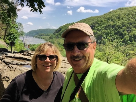
June 11-12, 2019 – Badlands of South Dakota

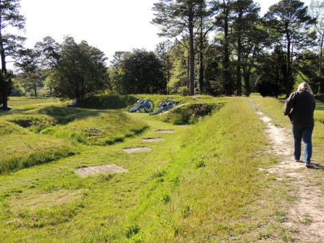
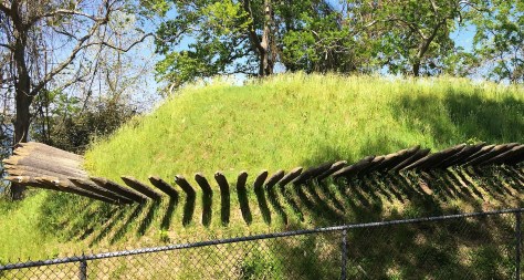
Badlands National  Park holds a special designation for me, as it was the first national park I visited in my youth. Since that time, we have been to many places that have similar qualities – particularly the Painted Hills in Oregon.  But none of those venues seem to combine the mud-like quality of the formations with the sharp spires that occur throughout this park.  Couple that with the fact that they rise from green prairies and you have a true ‘east meets west’ situation.  On this particular trip, we found that last reference had much more than one meaning.  More on that in a minute…

P1020145 (3)

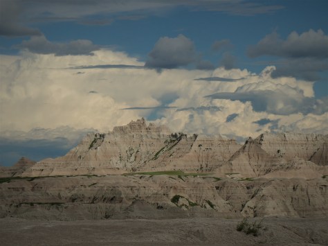
After setting up camp in Wall, we headed on I-90 to the east entrance of Badlands National Park.  This area was known to the Lakota people as mako sika, which roughly translates to ‘land bad’.  They were also the first to notice fossilized remains of sea creatures, leading them to correctly assume that the Badlands were once under water.  That’s quite the assumption for a tribe that was thousands of miles from the nearest ocean!

P1020151 (2)

Since becoming a national park, those fossils have become a focus of scientific study.  Besides the shells and fish bones you would normally expect in a marine environment, species such as alligators and rhinoceros were found here.  When we visited in 1990, I found a small jaw fragment while on a ranger-led tour.  Hopefully it is still where I observed it.

P1020157 (2)

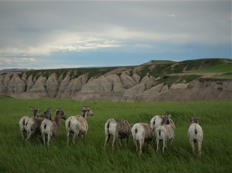
The park is also home to a wide variety of present day wildlife.  Here are several female Bighorn sheep that decided to moon the photographer.

P1020163 (2)

We saw prairie dogs by the hundreds.  This chubby guy stopped his meal long enough to pose for a profile shot.

P1020173 (2)

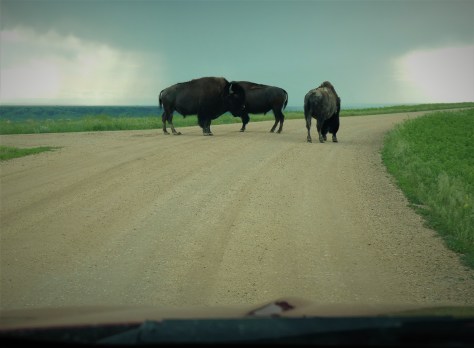
And this trio was not letting us pass until we snapped an image of them for the blog.  Consider it done!

As I had mentioned earlier, this trip introduced us to more than one meaning for the name ‘badlands’.  When exiting off of I-90, we saw a sign for the Minuteman Missile National Historic Site.  After questioning the ranger at the Badlands visitor center, we decided to tour there the next day.

Heading east again on I-90 from Wall, our first stop was just off the highway at Exit 116.

P1020182 (2)

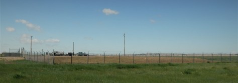
Along the side of the dirt road, this fenced-in compound sits in plain sight.  Not long ago, this was one of the United States’s hundreds of active missile silos.  This small parcel of land held a missile that was 120 times more powerful than the bomb dropped on Hiroshima.  If launched, the missile would’ve flown over the North Pole to Russia in about a half hour.

ells2 (2)

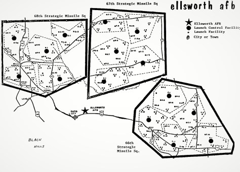
This facility was labeled D-9 of the 66th Strategic Missile Squadron.  Look closely at the map and you will see the towns of Wall, Sturgis, Belle Fourche, Lead, and Rapid City.  Chances are you’ve been within a stone’s throw from one of these silos at some point and didn’t even know it.

P1020185 (2)

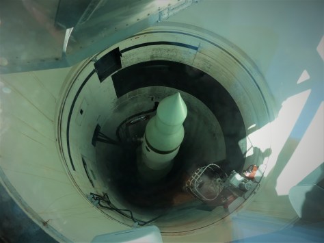
At this particular silo, visitors can peer in from the top to see a deactivated Minuteman II missile.  These particular rockets were taken out of service and most of the silos were imploded after the START treaty with the Soviet Union.  About 150 silos remain in Wyoming, North Dakota, and Montana with the much more powerful Minuteman III missile in each of them. 

P1020189 (2)

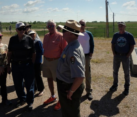
Growing up just three miles from the massive industrial complex known as the Ford Rouge plant, I was always aware that there was a big Russian target on my head.  Not a comforting thing to think about as a teenager, believe me.  With that in mind, I peppered this ranger with a myriad of questions about these silos.  He was actually a a missile commander back in the day, and was extremely open about the workings of this facility.

P1020190 (3)

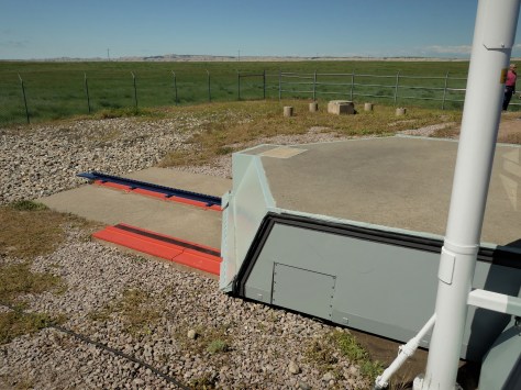
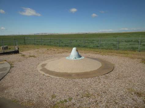
This heavy concrete lid covered the silo at one time.  It is currently welded partway over the silo, in accordance with the treaty.  In the 1983 television movie The Day After, there was a scene showing these lids retracting just prior to the missiles launching to their intended targets.  That scene sticks in my mind to this day.

P1020196 (2)

This is actually a hardened communications antenna.  Think of it as a nuclear-proof cell phone tower.  The ranger informed us that it would have not withstood a blast, even though that was the original intention.  When I could think of nothing else to ask, I thanked him for keeping us safe over the course of his career, which he appreciated.

After that sobering visit, we continued to Exit 130 and the Minuteman Visitor Center.

IMG_2911 (2)

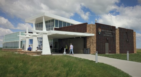
This facility has a museum, theater and gift shop.  A gift shop???  Do you really want to be reminded of a possible nuclear holocaust by drinking your morning coffee out of a Minuteman Missile mug? We viewed the movie, which started very much like The Day After, showing peaceful scenes with flyovers of fields of grain and unending prairies.  It didn’t take long for it to show images of nuclear weapons detonating, the polar opposite of the earlier idyllic segments.  After going through the nuts and bolts of the Minuteman program, they got to the story of one Stanislav Petrov, a missile commander from the Soviet Union.  Remember this man.

1ABA9D2A-1DD8-B71B-0BE0FF2327D15C06 (2)

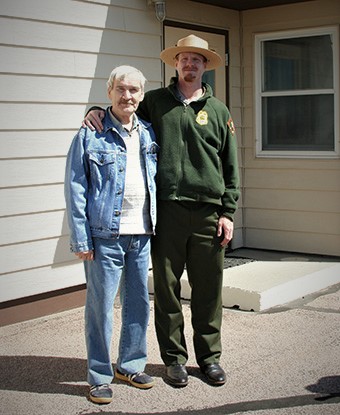
Seen here during a visit to the Minuteman National Historic Site a few years ago, he is credited with single-handedly saving the world as we know it.  In 1983, just before the above-mentioned TV film aired, this commander was alerted by his men of five incoming U.S. missiles on their radar screens.  Tensions were high at that time, as the Soviets had just shot down a Korean Air Lines 747 with 246 souls on board.  Petrov looked at the images and said “How can this be?”  He knew the U.S. would launch far more than five missiles, so he held back from reporting what he was seeing.  It turned out to be sunlight reflecting off high altitude clouds over North Dakota.  Had he let his superiors know, missiles would have started flying in both directions.  That inaction simultaneously ruined his military career and saved us all.  He eventually suffered a nervous breakdown from the stress of it all.  And if that wasn’t frightening enough, we learned later on in the museum that incidents like this happened twelve times…six on each side.  In one of them, someone on the U.S. side inserted a training floppy disk into a computer which lit up the radar screens with incoming Russian missiles.  Fortunately, someone discovered the error before the U.S. retaliated to a non-event.

IMG_2915 (2)

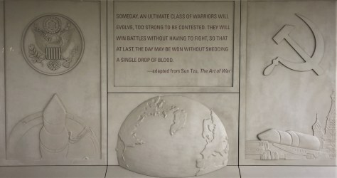
In hindsight, the quote on this display in front of the visitor center may be impossible to achieve, due to the human factor involved with these weapons.  After visiting this facility, we skipped the Junior Ranger badges this go around.  Personally I went a good half hour before I could say anything, as I had a sizable lump in my throat from that film.

P1020174 (2)

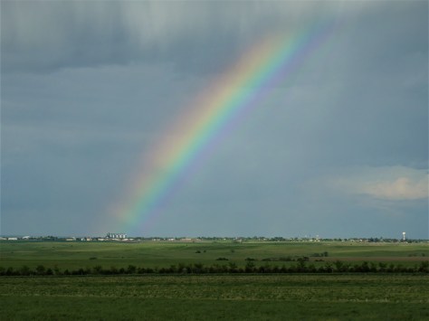
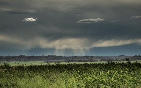
Still, it was a well done historic site worth visiting.  Petrov himself stated that never in his wildest dreams would he have thought he could visit such a place on the ‘enemy’ side.  Yes we were the enemy to them, as they were to us.  Hopefully, the only thing we ever see flying over Wall, South Dakota are rainbows and clouds.  Our wish for future generations is that the only ‘bad lands’ are the Lakota mako sica hills that dominate the landscape east of the Black Hills.

Next up, we head east through the remainder of South Dakota into the Missouri River region of the state.  Along the way, we found a pleasant surprise nestled along the river’s banks.  Be sure to stay tuned for that in next Saturday morning’s post.  Until then, safe and happy travels to all!


National Museum of the U.S. Air Force

October 22, 2018 – Dayton, OH

When we were planning our trip south to Florida this year, we were originally going to take I-77 through the western Carolinas. With the sudden appearance of Hurricane Michael we decided that might not be wise, as Hurricane Florence had already soaked the area to its limit.  Instead, we chose the old tried-and-true I-75 route that we used to take when we lived in Southeast Michigan.  That route took us through Dayton, Ohio…and allowed me to fulfill a decades-old promise I had made with Diana.

Back in the 1990’s, the two of us traveled with my parents from Northwest Ohio to Dayton.  Mom and Dad were living in Findlay at the time, and Dad wanted to take me to what was then called the Air Force Museum.  With him being a World War II pilot and me being a certified airplane geek, it was pretty much a no-brainer.  At the time, there was two large Quonset hut-style hangers housing the various aircraft, along with another hanger at the opposite side of Wright Field that held the Presidential aircraft.  We worked our way through the huge exhibition space, taking a very long time in the WWII section.  We exited the building and got in line for the bus across the field and BAM…they cut the line at the group directly in front of us.  Last bus of the day, and we were on the wrong side of the cutoff.  Diana was crushed, as the Air Force One display was the one thing she had her heart set on.  I promised her that we would return someday, and that the Presidential planes would be our very first stop.

IMG_1081

It took us twenty-some-odd years, but we made it!  We pulled up to what is now called The National Museum of the U.S. Air Force to find two additional Quonsets beside the original pair.  The entire collection is now in one location, meaning the bus ride across the base isn’t needed anymore.  As was the case on our last visit, the museum admission was free of charge.  🙂  Once inside, we headed straight to the newest building, as that was where the Presidential planes were.  As luck would have it, there was a guide who was about to start a tour of the entire hanger, so Diana thought we should join in.

IMG_1115

Above is a panoramic photo of that space, a whopping 224,000 square feet!  Over 70 aircraft and missiles are displayed in this area in four separate galleries:  Space, Research & Development, Global Reach, and Presidential.

IMG_1113

The Apollo 15 command module that orbited the moon is displayed here.  This is the fifth moon capsule we’ve seen! (Apollo 11, 12, 14, 15 and 16)

IMG_1110

They have a shuttle trainer that has a full-scale mock-up of the crew compartment. My thought looking at this is that the astronauts would have been flat on their backs during a launch.  How did they get into those seats on the launch pad?  Hmmmm….

IMG_1112

This satellite is called Teal Ruby.  It was supposed to be an inexpensive spy satellite that could do a lot of things.  Originally designed in the 1970’s, it’s ride on the shuttle kept getting pushed back.  When Challenger exploded, it got bumped back to a point that it would likely not fly (for multiple reasons).  During it’s development, this inexpensive little beauty saw it’s costs skyrocket (pun intended).  We are looking at a $500 million museum piece, folks.

IMG_1082

Above is the X-1B.  Similar to the earlier X-1 ‘Glamorous Glennis’  that Chuck Yeager broke the speed of sound in, this aircraft was capable of flying over 1,600 miles per hour.  For the record, that’s more than twice the speed of sound!  Oh, and above it?  That’s the right wing of a XB-70A.  That plane is one of two experimental B-70 bombers built in the early 1960’s, capable of cruising at three times the speed of sound at 70,000 feet…far above Russian fighter capability at the time.  The other plane crashed, leaving this as the only remaining example.  Improvements in Russian surface-to-air missiles brought an end to the program.

IMG_1084

In the Global Reach gallery, we were able to board the C-141C, better known as the Hanoi Taxi…the first plane to bring POW’s home from North Vietnam in 1973.  At the time, it was a C-141.  It was found that the planes would ‘bulk out’ before they ‘grossed out’…meaning they would be full well before their weight limit was reached.  The Air Force stretched the entire fleet of 270 planes to utilize the extra cargo carrying capacity, renaming the modified planes C-141B.  Near the end of the fleet’s career, 63 of the planes were modified with modern digital technology, thereby making them C-141C’s.  Many of them…including this one…evacuated victims from Hurricane Katrina.  15 of these planes are on display at museums around the country, with the remaining aircraft having been scrapped.

On to the Presidential planes!

The museum has a wide variety of aircraft that were used by presidents, beginning with Franklin D. Roosevelt.

IMG_1085

Roosevelt’s plane was called The Sacred Cow, due to its status.  It was the only VC-54C ever built. Douglas Aircraft Co. installed this special elevator to help the wheelchair-bound president access the plane.  He only used this plane one time, a trip to Yalta for the famous conference with Stalin and Churchill, two months prior to the president’s death.  Harry Truman used it extensively for the first 27 months of his presidency.  It is interesting to note that he signed the National Security Act of 1947 aboard this plane, which established the Air Force as a separate service.  That makes The Sacred Cow the birthplace of the U.S. Air Force.

IMG_1088

This was the small presidential conference room near the rear of the plane.

IMG_1091

Truman followed with another Douglas aircraft named The Independence, after his hometown of Independence, Missouri.  This was a modified DC-6.

IMG_1092

This is Truman’s chair in the small conference room in the middle of the aircraft.  One thing to note:  The aisles through all of these aircraft were glassed off and narrow.  Not an easy place to be for folks who are claustrophobic.

IMG_1094 (1)

Next up was Dwight D. Eisenhower’s Columbine III.  He had three Lockheed planes at his disposal over his eight years as president.  This was a stylish aircraft, best known for its distinctive tri-tail.  It was named for the state flower of Mamie Eisenhower’s adopted state of Colorado.  She christened it with Colorado water, instead of the traditional bottle of champagne.

The most famous Presidential plane in the museum has to be the SAM 26000.

IMG_1096

A modified Boeing 707, this was the first plane to sport the now-familiar paint scheme used on all of the Presidential planes.  That look was created by industrial designer Raymond Loewy and First Lady Jacqueline Kennedy.  This plane is best known for one fateful day: November 22, 1963.  At 11:30 that morning, the jet delivered President Kennedy to Dallas Love Field.  Less than three hours later, his body was brought back in a coffin to the plane after his assassination.  18 minutes after arrival, Lyndon Johnson was sworn in as President aboard the plane, with Lady Bird Johnson and Jackie Kennedy in her blood soaked skirt standing on each side of him.  Nine minutes after that, the plane departed for Washington D.C.

IMG_1102

To step aboard this aircraft is a humbling experience, to say the least.  It is to be noted that the plane’s interior was reworked several times, so nothing resembles what we saw on that fateful day.  The jet was used all the way into the Clinton presidency, finally retiring to the Air Force Museum in 1998, after 36 years of service.

A quick tour of other noteworthy planes in the museum:

IMG_1129

The famous B-17 bomber Memphis Belle, known for successfully completing 25 missions over Nazi occupied territory in WWII.

IMG_1121

A Wright 3 Flyer, last modified in 1923.

IMG_1131

The B-29 Superfortress Bockscar, known for dropping the atomic bomb on Nagasaki, Japan on August 9, 1945.  That bombing is what brought about the end of World War II.

IMG_1132

Again, humbling to see a Fat Man bomb that instantly wiped out so many people in that city.

IMG_1134

In the same display is a Little Boy bomb, the type used over Hiroshima.  This was once an operational bomb.

B1

The smooth lines of a B-1B bomber, with an F-15 fighter in the foreground.

IMG_1116

A B-2 Stealth bomber, able to fly undetected by radar.

IMG_1118

An A-10 Warthog, with its massive engines that are needed to counteract the recoil from its rotary cannon at the front of the plane.  Nothing worse than falling out of the sky by shooting your own gun!

IMG_1128

A Stearman trainer, in the color scheme that would have been used on the planes my dad flew at Maxwell Field in Alabama.

IMG_1124

My dad also flew in B-25 bombers as a tail gunner and co-pilot.  This display had to do with the Doolittle Tokyo raid, in which sixteen B-25’s, each with a crew of five, took off from the aircraft carrier USS Hornet and bombed Tokyo.  The mission was more a psychological victory than anything else, as not much physical damage was inflicted upon Japan.  The planes were unable to return to the Hornet, with fifteen of them crash landing in China.  The other plane landed safely in Russia.  All but three crewmen initially survived the mission.

IMG_1125

The Doolittle Raiders held a reunion from the 1940’s until 2013.  Each year, the men would toast their fallen comrades with cognac in goblets inscribed with their names. The names were right side up on one side of the goblet, and upside down on the other.  As each airman passed, their goblet was turned upside down in the case.  Robert Hite was the last surviving raider, passing away in 2015.

It’s at this point that I wish to address accuracy when sharing history as a docent in a museum.  Diana and I took our jobs at Heceta Head Lighthouse and at Sleeping Bear National Lakeshore very seriously, as to making sure the information we shared was correct. I’m not saying we are perfect, but our ultimate goal is to be accurate.  I am purposely not sharing the photo I have of our tour guide at the Air Force museum.  Story after story he told had an interesting twist.  When he shared the urban legend “Good luck, Mr. Gorsky” as fact…and followed it up with “Verified by the family of Neil Armstrong”, the story begged for us to Google it.  It’s a total whopper of a story, and it caused us to have to verify everything else he shared with us….most of which wasn’t completely true.  If he is reading this, he knows who he is.  History is amazing enough without making stuff up, my friend.  It was a stain on an otherwise great visit.

By all means, if you can spare the time while in Dayton, be sure to visit the National Museum of the U.S. Air Force.  In addition, there are several National Park sites that are part of the Dayton Aviation Heritage National Historical Park.  Most, but not all, are associated with the Wright Brothers.  It’s a fun place to explore!

Until next time, safe and happy travels to all!


Fun in the Hudson River Valley

May 12, 13, 15 & 16, 2018 – Hudson River Valley, NY

As we stated a couple of posts back, our base for seeing New York City was Newburgh, New York.  Located about an hour-plus north of NYC by rail, this charming area nestled in the Hudson River Valley is as if you are in a totally different world.  The rolling hills are dotted with small farms and little towns, in contrast to the metropolis to the south.  With us being in the vicinity for the better part of a week, we decided to explore and see what hidden gems we might find!

Saturday, May 12 was a cold, drizzly sort of day, we decided it would be a good opportunity to do some grocery shopping.  On the way to the store, Diana did a little Google search and informed me that Angry Orchard Hard Cider was located near there in the town of Walden, and that they had live music that afternoon. Seeing that this cider is available across the nation, I had always assumed Angry Orchard to be a fictional place.  Apparently, this wasn’t the case.  I made a quick U-turn and we headed to the cidery.  Groceries can wait until later!

z11

This very real place is filled with gnarly-looking apple trees.  According to the company, the angriest trees produce the best cider.

z9

It is here that they have what is known as their Innovation Cider House.  This is where they offer new flavors and blends to their guests, before sending it out to the masses.

z6

Everyone of drinking age is given a free flight of three different ciders, and the bar offers several other flavors for sale.  As you can see in the photo above, the complimentary pours are a decent size!  Diana also tried their Rose.  I had a pint of their Maple Wooden Sleeper, which is aged in bourbon barrels.  It has a somewhat dryness to it, with hints of maple, vanilla and bourbon. At 12% ABV…double their normal offering…it also earns the name ‘sleeper’!

z7

They had a duo that afternoon, which made for a great atmosphere!  We were sitting at community tables with several locals, which was a lot of fun.

z8

They have a self-guided tour that ends with this showcase of the awards they’ve won.  Most were from the Great Lakes International Cider and Perry Competition.  Hmmmmm…..never heard of that, but it might be worth checking out sometime!

Sunday, May 13 was another rainy day, so we decided to head across the river to Hyde Park.  We had visited this town back in 2007 to see Franklin Delano Roosevelt’s home and Eleanor Roosevelt’s cottage, Valkill.  Both were amazing and are recommended by us, if you are in the area.  This time, we visited FDR’s neighbor, the Vanderbilt mansion.

z10

Frederick and Louise Vanderbilt had this estate built in the late 1890’s as a summer escape from the heat of New York City.  These are the people who owned the New York Central railroad and are responsible for the beautiful Grand Central Terminal we love so much.  When Frederick passed in the 1930’s, he willed the mansion to his niece.  After unsuccessfully trying to sell it, FDR convinced her to donate it to the National Park Service.  It has been in their care since 1940.

z14

This is the dining room.  The table actually looked small in this room, but our guide explained that the couple only entertained a few guests at a time.

z12

This is Louise’s bedroom.  Lots of gold leaf adorning the walls.

z13

This is the man cave, so to speak.  I’m sure there were plenty of cigars smoked in this room!

Tours are offered at $10 each. Although it doesn’t state it in their literature or on their website, NPS Interagency Annual Passholders are admitted at no charge.  We didn’t check, but that is probably the same at the Roosevelt sites, so be sure to ask.

On Tuesday May 15, we decided to check out the nearby town of New Paltz with our friend Kathy.  We met her while working at Amazon in 2016 and we’ve been fortunate to see her twice between then and now.  Check out her new blog called Wonder Woman Wandering.  After checking out a few stores, we grabbed a drink at a local watering hole.  While there, everyone’s phones went crazy as there was a tornado warning.  We looked at the radar and it appeared we were OK where we were, but we decided to head back to camp, just in case.  Later that evening, a nasty storm hit.  While it was bad by us, it was much worse just to our south.  Huge trees were toppled everywhere and a couple of people were killed when they fell on them.

The next day, the three of us decided to do some more exploring.  On a stop at Walgreens to pick up a prescription, we saw this:

z15

I guess this is why it’s a good idea to have a backup generator.  All of their dairy coolers had lost power in the storm.

We headed to Minnewaska State Park on a quest to do a little hiking.

z2

This is Awosting Falls from above.  We continued down the trail to see what they looked like from below.

z4

Very pretty!  These falls are located on the Peters Kill River, which was flowing rapidly with the recent rains.

z5

Diana and Kathy spotted this interesting boulder across the river with trees growing over it.  🙂

We then drove up to Lake Minnewaska to see what that looked like.

z3

Kathy read a sign that told how the quartz that underlies the lake prevents the acidity from being filtered out.  As a result, this body of water doesn’t have any fish.  It is a picturesque scene, nonetheless.

On the way back, we made a stop at Kelder’s Farm in Kerhonkson.

z16

Kathy had spotted this garden gnome in Roadside America, as the largest in the world when it was made in 2006, and said “Now THAT’S a selfie moment!”  By golly, I believe she is right!

To cap the day, we stopped at Tuthilltown Distillery to sample what they had to offer.  They had some excellent bourbon, but their prices reflected their small size.  We did enjoy the tasting, though!

That wraps up our time in New York and the Hudson River Valley for the time being.  Next up, we visit with friends in Connecticut and Rhode Island.  Be sure to stay tuned for that.  Until then, safe travels to all!

Harpers Ferry & Delaware Water Gap

“Take me down to Shenandoah

To the joining of the streams

Take me back to Harpers Ferry

Let me revel in my dreams”

Greg Artzner/Terry Leonino


May 6-7, 2018 – Harpers Ferry, West Virginia

May 8-9, 2018 – Delaware Water Gap, Pennsylvania

z8

At the far eastern tip of West Virginia, where the Shenandoah River empties into the Potomac, lies the tiny river village of Harpers Ferry.  From the point in town where the rivers meet (as seen above) the eastward view shows Maryland to the left, Virginia to the right and the Potomac rolling onward towards Chesapeake Bay.  This hamlet was named for Robert Harper, who purchased a ferry service in 1747 from a squatter who had established it fourteen years before.  The land itself, owned by Lord Fairfax, was purchased by Harper in 1751.  Since that time, the town has seen more history than most communities of its size, and it continues to be a magnet for people from all over the world.

zzzz

Across the river in Maryland the vantage point known as Maryland Heights offers a commanding view of Harpers Ferry.  Two railroads run through the lower portion of town, which is built on a flood plain.  As one would expect, floods have had a major impact on anything built there over the years.  This area was home to most of the commercial and industrial parts of the community.  The upper part of town is mostly residential, churches, and small retail shops.

z14

We climbed up there via steps that are cut into the rock that the village is built upon.

z11

Along the way, we passed the Harper House, where Meriwether Lewis is believed to have stayed when he came here in 1803 to procure weapons and supplies for his expedition to the Pacific.

z12

At the top of the steps is St. Peter Catholic Church.  Its commanding perch on the hillside ensures that its steeple can be seen for miles.

z22

Continuing upwards, we passed the ruins of St. Mark’s Episcopal Church.

zzwz

Our destination was Jefferson Rock.  This balanced shale (supported in the mid-1800’s) was the place Thomas Jefferson stood in 1783, declaring the view as “perhaps one of the most stupendous scenes in nature”.

z9

That was one vista we needed to explore!

The lower town is home to Harpers Ferry National Historic Park.

z20

Many interesting little shops and displays can be found there, covering the varied history of the village.

z2

This display shows a recreation of the rifle works in the U.S. Armory that was located here.   Interchangeable weapon parts were invented at the armory.

z6

And I was very glad to see a recreation of the “experiment”, the iron-framed boat Lewis and Clark brought west with them.  I had read about in in the book Undaunted Courage, but I couldn’t visualize what it looked like.

z7

The plan was to stretch animal hides over the frame and seal the seams with pine tar.  The problem came about when there wasn’t any pine trees to be found when it came time to assemble it above Great Falls, Montana.  They substituted beeswax, buffalo tallow and charcoal, hoping it would hold.  According to Lewis the boat floated “like a perfect cork on the water”, until the beeswax mixture let loose and the craft began to sink.  He ordered the frame to be buried and they continued on their way without it.  They did dig it up to inspect it on the return trip (as noted in his journals), but that was the last mention of it.

z3

There was also a fair amount about abolitionist John Brown, who was captured in this building after a siege of the armory in 1859.  Brown believed the only way slavery would be overthrown was by the use of violence.  His reason for the raid was to obtain weapons in order to arm slaves. The capturing forces were led by Robert E. Lee, then a colonial in the U.S. Army.  Brown was charged with treason and hanged in nearby Charles Town.  His efforts captured the attention of the country, and are considered to have contributed to the start of the Civil War.

z23

Speaking of that war, this life mask of Abraham Lincoln was on display in one of the buildings.  It had been done just two months before he was assassinated.  It was surreal to look at, knowing the mold that formed this had actually touched his face.  It really looks like the stress of the war took a toll on him.  Those hostilities were also hard on Harpers Ferry, as the community changed hands eight times between the north and south from 1861 to 1865.

Moving from the past to the present, we wanted to note a few of the recreational opportunities available in the area.

z15

From a distance, Diana saw this woman rock climbing below Maryland Heights.

z13

Also, on the near side of this bridge, there is a pedestrian walkway.

z4

That’s actually the Appalachian Trail.  Now we can say we hiked from West Virginia to Maryland.  😉

z5

Even though this isn’t the exact center, most people consider it the psychological halfway point of the 2,178 mile long path.

z10

And Harpers Ferry is home to the Appalachian Trail Conservancy, a place we really wanted to visit.  It is a great rest spot for the trail users, offering loads of information and computer access.  They take a photo of each hiker and keep binders as a history of thru hikers. We have to admit, making that journey has crossed our minds on occasion over the years. You can always complete it in segments…

On May 8, we headed north to Delaware Water Gap in Pennsylvania.  Our reason for the stop was so that we could meet up with one of Diana’s childhood friends.

z17

Ellen and Diana were in Girl Scouts together.  And speaking of long hikes…

za2

…Ellen had a photo of when the troop hiked across Michigan from the shore of Lake Huron to the shore of Lake Michigan.  Diana still has her “Shore to Shore Hiker” sweatshirt in storage.  🙂

The next day, Diana and I checked out the Delaware Water Gap National Recreation Area.  Unfortunately, most of the trails had been recently damaged by a late winter storm, so many of the waterfalls were inaccessible.

z1

We did find that the trail to Raymondskills Falls was recently reopened, so we walked down to check that out.

z21

They were very pretty, and it was good to get out on a trail in the woods again!

z18

This smaller waterfall off to the side was particularly nice.

z16

Even though most of the park was inaccessible, Raymondskills Falls provided a little sampling of what Delaware Water Gap has to offer.  If we get back this way, we will hike to some of the other falls!

Next up:  Come along with us as we log some major Fitbit steps in New York City. 🙂  Be sure to stay tuned for that adventure!

Of special note:  We wanted to mention the passing of fellow blogger and fulltime RVer, Lynne Braden.  She was the author of Winnie Views,  the travel stories of her and her late yellow lab Millie.  The way she faced her terminal cancer with grace was an inspiration to us.  Though we never met in person, we kept in contact with her through our blogs and by email.  We will truly miss her and her cheerful smile. Her legacy lives on through her generous donation to Bosque del Apache National Wildlife Refuge, the place that gave her the first opportunity to volunteer.  The next time you see a Sandhill Crane, smile and think of Lynne.  🙂


Why Yorktown Took Us by Surprise

May 1, 2018 – Yorktown, Virginia

Not far from the last two places we visited…Jamestown and Williamsburg…lies Yorktown, Virginia.  While the first two are considered to be the beginning and the middle of colonial America, the latter is where the United States finally won their independence from Great Britain. Coming to this important place for the first time, we knew very little about what took place here; the third leg of the Historic Triangle.  What we found totally surprised us!

Here is a quick synopsis of what happened in 1781:  Britain controlled New York and also was building a commanding presence in Virginia.  George Washington’s troops were readying themselves for an assault on New York, along with a large army of French soldiers led by Comte de Rochambeau.  Another group of Americans, led by French commander Marquis de Lafayette, was shadowing the British in Virginia.  Yet another group of French led by Comte de Grasse and located in the West Indies, promised naval support to the cause.  When Grasse sent word that he was headed to Virginia, Washington and Rochambeau had little choice but to do the same.   Washington left a skeleton crew in New Jersey to maintain the guise of a full camp by tending to hundreds of campfires and tents.  By the time the Brits figured out that the enemy was headed south, the French navy had already blocked the mouth of the Chesapeake Bay and the combined American/French troops were well on their way to Yorktown.  Lord Cornwallis and his 6,000 man army were about to be surrounded by a force of 8,800 Americans and 7,800 French, along with the 35 French warships in the bay.  British commander Henry Clinton sent 25 ships south to take on the French, but were effectively driven back north by the larger navy.  Cornwallis was on his own.  The French and American armies attacked from the south, pinning the Brits against the York River.  Efforts to retreat across the waterway were foiled by a sudden storm, which all but sealed their fate.  Cornwallis surrendered, and the final battle of the Revolutionary War was complete.

So what was it that surprised us at Yorktown?  Well, first of all, the Americans couldn’t have won without the help of the French army and navy.

zz4
Diana walks the American First Parallel, which was built in one night.

Why did they come to our aid?  They and the British had been vying for power in North America for quite some time, and the French recognized the United States as an independent nation with the Treaty of Alliance in 1778. By backing the Americans, they would have a better economic stance in the New World.

zz10
Jim peers from an American position towards the British fortifications.

Also, George Washington did tell a lie, in the fact that he deceived the British into thinking he was staying in New York.  We forgive him for the fib.  🙂

zz3
The far ridge is the British defensive line. The brick walls in the foreground encompass a Civil War cemetery. The ridge just beyond the brick walls is the American Second Parallel.

And did you know that a full third of the combined armies were German?  The reasons behind that are many, but just the fact that they were there surprised us.

zz1
Redoubt 9, which the French took over with 400 men.

The final maneuver by the Americans was accomplished without using loaded muskets.  A division of U.S. men captured Redoubt 10 using only bayonets.

zz2
The remains of Redoubt 10, which the York River is slowly reclaiming to erosion.

The British had a long list of demands when they surrendered, which were rejected by Washington.

zz6
The Moore House, where the actual surrender was signed.

The British marched into what is now known as the Surrender Field between a long column of Americans on one side of the road and French on the other.

zz7
The Surrender Field.

It was here that they laid down their unloaded weapons.  Seeing that the British still held New York, none of the participants knew that this was the battle that eventually won the war.

zz8
A portion of the 242 cannons that were surrendered by the British.

Great Britain lost the will to fight a war far from their shores and withdrew from New York after the Treaty of Paris in 1783.

zz9

The Victory Monument stands in Yorktown to commemorate the end of the Revolutionary War.  With our visit to the Historic Triangle complete, we moved on to Charlottesville, Virginia.  Be sure to see the cool things we found there in our next post!

Wright Brothers at Kitty Hawk

As long as there have been humans watching birds soar through the skies above them, mankind has wanted to fly.   Jean-François Pilâtre de Rozier and François Laurent d’Arlandes  floated skyward above Paris in 1783 using a hot air balloon.  In 1853, George Cayley witnessed the successful manned flight of a glider that he had invented in England.  It was he who identified the four basic principles of flight that a heavier-than-air aircraft uses today:  thrust, gravity, lift, and drag.  He also identified the cambered shape of a bird’s wings, which create lift as air passes over them.

In the 1890’s, two bicycle shop owners from Dayton, Ohio, decided to try their hand at building an airplane.  Orville and Wilbur Wright used Cayley’s principles to construct a two-winged glider.  In order to test it, they needed a location with a soft landing surface (sand), a hill, and sustained winds.  Noting the media circus that had taken place near Chicago when Octave Chanute had tested his gliders, the Wrights were also looking for privacy.  They contacted the weather bureau for locations with the best sustained winds.  Kitty Hawk, North Carolina was chosen, after the hamlet’s postmaster responded favorably to an inquiry from the brothers.  William Tate’s reply included help with the endeavor in any way he could.  The crew of the local U.S. Lifesaving station also offered to lend a hand when needed. In 1900, the Wrights brought their first glider to Kitty Hawk by train to give it a try.  The first tests were flown unmanned and tethered as a kite.  Then Wilbur flew aboard untethered to see if he could control it.  They had come up with an idea they called wing warping…a process in which the wings were bent in one direction or another to steer the plane, along with an elevator to maneuver up and down.  They determined the glider needed to be larger, as they weren’t able to stay in the air long enough to adequately test the controls.  In 1901, they brought a larger glider to Kitty Hawk, only to find that their wings weren’t producing enough lift.  They had been relying on data produced by Germany’s Otto Lilienthal, who had died in 1896 in a glider crash.

After abandoning Lilienthal’s figures and testing 200 wing designs in their homemade wind tunnel, the Wrights set out for Kitty Hawk in late 1902 to try out their new glider.  They had also added a rudder to the plane, thereby giving them three ways to control it.  It worked.  Over a one month period, they made approximately 1,000 flights…with one being 622 feet.  Systems they developed that year, are still the basis for aircraft today.

In 1903, they decided to add power to their aircraft.  Their bike shop employee, Charlie Taylor, machined a light weight engine for them out of a solid block of aluminum.  The Wrights fashioned propellers out of laminated wood. They had no basis for design, other than the props from ship motors.  After much discussion, it was decided that the propellers should exhibit the properties of a glider wing.  Their theory proved correct, and their creation was over 80% efficient.  Not bad for not having a starting point!

On December 14, the brothers flipped a coin to see who would fly first.  Wilbur won. They attempted to take off from Big Kill Devil Hill, the large sand dune they had been using for glider flights.  The plane lifted off for three seconds and then stalled, as he had attempted to rise too quickly.  The landing broke the front elevator. Three days later, they summoned the lifesaving crew over to the hanger.  The group aimed the airplane into a cold, 27 mile-an-hour headwind on level ground.  Since Wilbur piloted the previous attempt, Orville climbed on board.

z14

The aircraft lifted off for a 12 second, 120 foot flight!  Orville was able to bring the plane in for a somewhat controlled landing.  Wilbur then took the plane for a 12 second, 175 foot flight.  Orville followed with a 15 second, 200 foot flight.  The last flight of the day was by Wilbur; a 59 second, 852 foot flight.  That is almost the length of three football fields!  The plane landed hard and again broke the front elevator.  While bringing it back to the hanger, a gust of wind caught the plane and caused it to tumble end over end, which made repairs much more difficult.  They decided to call it a season, as they wanted to be back in Ohio for Christmas.  The plane was packed up, and sent back to Dayton, never to be flown again. Eventually, the restored plane made its way to the Smithsonian Institute in Washington, D.C. where it hangs from the ceiling today.  They continued improving upon their design, and eventually achieved their goal of selling planes to the military.

When Diana and I found our way to the Outer Banks of North Carolina this spring, we knew Kitty Hawk was one of the ‘must see’ destinations.  The National Park Service operates the site of the flights as the Wright Brothers National Memorial.

z2

At the top of Big Kill Devil Hill, a large granite pillar is erected to signify their accomplishment.  Note that the area is completely covered in grass now, planted to keep the hill from shifting southward from the prevailing winds.

z3

When we got to the front of the structure, we noticed the sun was positioned directly in line with it.  The clouds also had an interesting pattern to them, which we thought was neat.

z10

The size of the memorial is impressive, to say the least.  The inscription that is inscribed in the base reads  “In commemoration of the conquest of the air, by the brothers Wilbur and Orville Wright, conceived by genius, achieved by dauntless resolution and unconquerable faith.”

z1

The view from the top shows the position of the hanger and their workshop and living quarters, along with the markers that signify the length of each flight.  In 1903, neither those houses in the distance nor trees were there.

z19

From the large granite marker at the end of the rail where they took off, a path runs along four smaller markers that signify the length of each flight.  Walking along it, I thought of all of the subsequent accomplishments in the 115 years since that day. All of us have been touched in one way or another by what happened at Kitty Hawk.

z5

On the back side of Big Kill Devil Hill is an interactive sculpture of Orville’s first flight, shown here from the photographer’s point of view.

z6

All of the men who were present for the event are depicted.  The second man from the right is a lumberman from Manteo who just happened to be at the lifesaving station when the Wrights signaled the crew to come over and help.

z7

Visitors are encouraged to climb aboard the plane.  Diana and I took turns flying with Orville.  A fun way to end a perfect visit!

Stay tuned to see what else we find as we explore the rest of the Outer Banks in our next post.  Until then, safe travels!


Charles Who?

As we were exploring Charleston, we kept coming upon a name that sounded familiar to us:  Charles Pinckney.  That was due in large part to our Michigan lineage, as there is a town in the Wolverine state named Pinckney.  I remember it well, as I did a 50 mile bicycle ride there one day with some friends.  After some research, it turns out that the South Carolina Pinckneys appear to not be related to the Michigan clan.  But who was this Charles Pinckney, and why does he have a national historic site in his honor?  Well, it turns out that there were several people by that name in Charleston.  In this post we are going to focus on the one who is honored at Charles Pinckney National Historic Site.

z2

Charles Pinckney (October 26, 1757 – October 29, 1824) came of age in a wealthy family as the people of the English colonies in America prepared to declare their independence from Britain. As a young man he fought in the Revolutionary War.  He was captured during the battle of Charleston and was taken prisoner until after the war ended.  Over his career, he was a four term Governor of South Carolina, a U.S. Senator, a U.S. Representative, and an ambassador to Spain.  But his biggest claim to fame was as a member of the Continental Congress when the U.S. Constitution was drafted.  On May 29, 1787, he submitted a plan to the convention that was called the Pinckney Draught.  It was similar in many ways to the Virginia Plan, calling for the following:

  • Three branches of government: Congress, Judicial and Executive branches.
  • A separate House and Senate.
  • A President shall inform Congress the conditions of the nation (State of the Union).
  • The President shall be Commander-in-Chief.
  • No state shall coin money, establish tariffs, keep troops, or enter into a treaty.
  • Only the House shall have the power of impeachment.

He also exclusively came up with the idea that no person should be held to a religious test to hold any elected office in the United States.

Eventually, ideas from all of the plans presented were woven into what became the United States Constitution.  Pinckney spoke often during the convention that was responsible for the creation of the instrument, and his signature is on the final document.

So how did his country plantation become a national historic site overseen by the National Park Service?  At first glance, the answer to that is a bit confusing…as the 1820’s era home that occupies the site was built by a subsequent owner.

z3

It turns out that the property had been sold to developers in the latter half of the 20th century.  Most of the original 715 acre estate was turned into a golf course, homes, and such.  US-17 even runs through it.  When the builders began to prepare the final 28 acres for development into 42 individual home sites, a group of local preservationists led by two women came to the rescue.  In 1986 they negotiated a $2 million purchase price, and proceeded to raise the money to cover it.  In 1990, they donated the property to the National Park Service.  The park opened to the public in 1995.

z4

The grounds are beautiful, with several paths winding through the property.  Over 150,000 artifacts have been unearthed from the site, along with the foundations from the original buildings.  The visitor center has many displays regarding Pinckney’s life of service, several of the found artifacts, and an interesting display on the Gullah culture along the lower Eastern seaboard.  Gullah is a language developed by the slaves that has an English base with West African influences.

z5

A fantastic example of the language is this Bible they have on display.  The English translation is on the sidebars.  I found it mesmerizing.  They actually let visitors page through it.

As with our other recent National Park visits, we completed our Junior Ranger books and earned our badges.  Having to search the displays for answers really makes sure we read each display carefully.  While the Charles Pinckney National Historic Site wasn’t a major attraction, we were glad we made the effort to go there.  We now have an appreciation for the man and his contributions to our nation.  As we see his name in the future, we will have a better understanding of who he was and where he came from.

Next up: A serendipitous assignment of campsites in Myrtle Beach.  Be sure to see the amazing meetup that resulted from that, and the friendships that came about as a result!  🙂

A Harbor Well Protected

Charleston Harbor is home to one of the most significant historic sites in the nation; Fort Sumter.  This massive brick structure at the entrance to the harbor saw the first shell of the Civil War explode above its walls. With that said, there are other historic military compounds around the perimeter of the harbor…each having significance in their own unique way.  Come on along as we tour these fascinating locations and find out the importance each one holds.  We even found a few surprises along our path!

Fort Sumter

z30
© moultrienews.com


Fort Sumter was not the first defense built in Charleston Harbor, but it was by far the most imposing.  Built in 1829, it was intended to defend against invaders coming in from the ocean. Able to fire cannons at three levels, it appeared to be invincible.  The Confederate states needed control of this fort, in order to bring supplies into Charleston and beyond. On April 12, 1861, Confederate Brigadier General P.G.T. Beauregard ordered his soldiers to fire upon the garrison that was held by Union Major Robert Anderson and 85 men under his command.  It was a difficult decision for Beauregard, as Anderson had been his artillery instructor at West Point.  The Union soldiers were not effective in hitting any Confederate targets, as the rebel forces were spread out around the large waterway.  The flip side of the coin was that Beauregard’s men had one thing to focus on, and they inflicted heavy damage.  When the Union soldiers called a truce on April 14, Fort Sumter had been heavily damaged.  Amazingly, no one had been killed in the battle on either side.

Once the Confederates held the structure, it was the Union’s turn to try to get it back.  Several attempts were made, but the South had a firm hold on it and the harbor.  Remember the building was tall, massive, and made of brick.  By 1865, the North had pounded it with seven million pounds of artillery shells. Most of that brick fell and created a solid mound of material that was stronger than the original fort. Only Sherman’s troops approaching on their March to the Sea, were enough to cause the Confederate troops to abandon the fort.

z3

Today’s structure bears little resemblance to the original.  The fallen brick has been cleared away and the lower portion of the walls are once again in view.  The black concrete battery in the center of the fort was completed in 1899, in preparation for the impending Spanish-American War.

z7

That battery was manned in both World Wars I & II, after which point the fort was decommissioned.

z4

Little remains of the lower level casemates.

z5

The older brick against the relatively newer concrete.

z6

This massive leaning wall was knocked off kilter when the powder magazine behind it accidentally exploded, killing 11 Confederate soldiers.  The National Park Service has installed these metal supports to prevent it from moving further.

Note that access to the island is by ferry boat, either from Liberty Square in Charleston or from Patriot’s Point in Mt. Pleasant.

z1

We chose the latter, which gave us this awesome bow view of the U.S.S. Yorktown aircraft carrier as we passed by!

Castle Pinkney

z8

Castle Pinkney sits in the center of the harbor, between Fort Sumter and Charleston.  Built in 1810, it was used for six weeks as a prisoner of war camp during the Civil War.  It also housed artillery, although it is believed that a hostile shot has never been fired from there.  In 1924 it was designated as a national monument, only to see that status taken away in 1951.  It was deemed excess property and sold to the South Carolina in 1958.  Attempts to turn it into a tourist attraction failed, so the state tried to give it back to the federal government.  They declined the offer. The Sons of Confederate Veterans took over care of the island, but were unable to raise the cash to buy it.  Finally, in 2011, the State of South Carolina sold Castle Pinckney to the Sons of Confederate Veterans for the sum of $10…in Confederate currency.  The Stars and Bars of the Confederacy fly over it today.

Fort Johnson

Fort Johnson was built in 1708.  Only a small powder magazine remains at the site that actually fired the first shot of the Civil War.  The rest of the site is occupied by South Carolina Fish and Wildlife and the College of Charleston.  It is unfortunate that this prominent place in American history wasn’t preserved.

Fort Moultrie

Last, but by no means least, is Fort Moultrie.  This location has the longest history of all the Charleston garrisons, having been manned for 171 years.

z2

Located on Sullivan’s Island, this was the second defensive structure built to protect Charleston.  Due to the natural curve in the river channel, ships had to pass here before they were ever within sight of town.  Soldiers would fire a cannon to notify the townsfolk of an approaching ship.  In 1776, a palmetto log fort was constructed by Colonel William Moultrie and his men to defend against a British invasion.  They fought a one day battle that heavily damaged the enemy ships, yet little damage was done to the fort.  Turns out that palmetto logs, a member of the cabbage family, are fibrous.  The British cannonballs simply bounced off.  To add insult to injury, the American soldiers would retrieve the balls and fire them back.

During the battle, the soldiers wore hats with a crescent. The shape had the word ‘Liberty’ inscribed in it.  This was also on South Carolina’s flag.  A palmetto tree was added to the flag at a later date to signify the palmetto logs of Fort Moultrie.

z12

That symbol is everywhere throughout the state.  Coffee mugs, keychains, license plates…you name it.  At first glance, we thought the flag represented a waning moon rising or setting over a palm tree.  The crescent represents a gorget, the throat plate that protected officers’ throats at that time.  In designing the flag, Colonel Moultrie chose the the crescent and blue color to match the uniforms they wore.  So much for that romantic image of an evening walk on a South Carolina beach with your sweetheart. 🙂

Between the Revolutionary and Civil wars, the fort continued to be manned.  It is interesting to note that a young private by the assumed name of Edgar A. Perry was stationed there from 1827 through 1828.  We know him as Edgar Allan Poe.  Fittingly, the establishment we ate at on the day of our tour of the fort was called Poe’s Tavern.

Another resident of the fort at that time was the famous Seminole leader, Osceola.  He was held there by the U.S. Army after being taken prisoner under a flag of truce in Florida.  In failing health, Osceola died there in 1838.

z9

His grave lies just outside the fort gate.  The John Anderson classic Seminole Wind came to mind as we stood there.  While it is sad that he isn’t buried in Florida, it is nice that he is given an honorable grave.  Also on the property is Colonel Moultrie’s grave, which is along the shore of the cove behind the visitor center.

At the beginning of the Civil War, Major Robert Anderson was originally garrisoned at Fort Moultrie.  By 1861, the walls had gone from palmetto to being made of brick.  However, the Union commander felt it was indefensible, as the area around it had been developed with homes that looked down into it. The Confederate army took over the post after Anderson and his men left for Fort Sumter.  Fort Moultrie had one of the best positions to shell Fort Sumter, with only a mile separating them.

Like Fort Sumter, Fort Moultrie had batteries built in the late 1800’s.

z14

These were used through World War II.  A gas and bombproof building was added following World War I.

z31

Referred to as HECP/HDCP, it was a joint command post run by the Army and Navy.  The building is maintained as a museum as it would have looked in the 1940’s.  It is interesting to note that German U-boats slipped past this post and mined Charleston’s harbor at different times in the war.

z11

We had a great time exploring the forts around Charleston this week.  We even earned two Junior Ranger badges in the process!  Stay tuned for one last adventure in Charleston, along with our move up the coast.  We hope you will tag along!


Fort Pulaski

On the east end of Cockspur Island, in the middle of the Savannah River, sits one of the most massive brick fortifications ever built; Fort Pulaski.  This impressive structure was named for Count Casimir Pulaski, a Polish soldier who fought in the American Revolution and lost his life during the Battle of Savannah in 1779.  It was constructed over an 18 year period beginning in 1829, and sits on the Georgia side of the border with South Carolina. Sporting 7-1/2 foot thick walls that tower 32 feet above the 8 foot deep moat, it was felt that the structure was impenetrable.

z15

It was part of a coastal defense system put into place by President James Madison after the War of 1812.

z20

It is interesting to note that preliminary construction of the fort…including the canal system seen above…was the first assignment for a young cadet fresh out of West Point by the name of Robert E. Lee.  He was here from 1829 until 1831.

Even though it was completed in 1847, Fort Pulaski had not yet been manned by the army, nor was it fully gunned by the time 1860 rolled around.  On January 3, 1861, Georgia governor Joseph E. Brown ordered the state militia to occupy the fort.  This was in response to federal troops seizing Fort Sumter to the north at Charleston just two weeks earlier, after South Carolina voted to secede from the Union.  Savannah was an important port for the southern states, and vital to the success of the Confederacy.

z16

Work began in earnest to ready the post for the battle that was sure to come.  Thick timbers, such as can be seen in the photo above, were leaned against the inner walls.  This allowed a protected passageway between the casemates that surrounded the perimeter.

z14

Within a year, Union troops were setting up a series of 11 batteries on nearby Tybee Island, just to the southeast.  Those positions are signified in red in the above photo.  With the south and southeast walls of the fort (noted in green) at more than a mile away, it was felt by the Confederates that they were safe from anything the Union army could lob at them from that distance.  What they did not know was that the Federal troops had a new weapon: the 30 pound Parrott rifled cannon.  This gun had spiraled grooves the length of its bore which increase the accuracy and velocity of its 30 pound bullet-shaped projectiles.  This gun had a range of nearly five miles, so breaching Fort Pulaski’s walls at a mere mile away was a fairly easy task.  There were five of these guns in the Union’s arsenal on Tybee’s shore, along with five smaller rifled guns and twenty-six mortars.

z2

On April 10, 1862, Captain Quincy A. Gilmore sent a boat to Cockspur under the flag of truce to demand the confederates surrender the fort.  That demand was refused, so Gilmore ordered his men to open fire. Thirty hours and over five thousand shells later, the Union army opened a hole in the southeast corner of the fort.  The area that was destroyed was reconstructed and can be seen above as darker red brick.  The rest of the garrison walls still show the damage to this day.  Fearing that his powder magazines would be breached and the entire fort would be destroyed by the resulting explosion, Confederate Col. Charles H. Olmstead surrendered.  Similar to the unsinkable Titanic that sank almost 50 years to the day later, this impenetrable fort was penetrated.  Needless to say, confederate leaders were shocked.

z4

Visitors today can still see some of the shells embedded in the walls, the backs of which all face northeast.

z3

Even the tip of the southeastern-most cannon was damaged in the battle.

z12

This is the view the Union soldiers had from Tybee Island, about one mile from the garrison’s southeast flank.

z13

Amazingly, little Cockspur Island Lighthouse received hardly any damage during the siege, even though it was in the direct line of fire.  It is still standing strong.  It was re-lit in 2007 for historical purposes.

The 30 hour battle at Fort Pulaski rendered brick fortifications obsolete.  Union troops repaired the hole in the outer walls and turned the structure into a prison until the end of the war.  It was here that the Immortal Six Hundred…Confederate prisoners who refused to take an oath of allegiance to the United States…were held under horrible conditions. Thirteen of them died there and were buried along the outside bank of the moat. By 1880, only a lighthouse keeper and a caretaker remained.  They too were soon gone, and the fort was left to the forces of nature.  In 1924, Fort Pulaski was made a national monument, with restoration efforts taking place during the Great Depression.

z17

We learned a lot from our visit to Fort Pulaski, all while each adding a Junior Ranger badge to our collection.  If there is one important takeaway from this monument, it is the fact that no one is invincible.

Stay tuned to see what we find as we explore further up the coast.  Until next time, safe travels!

Jekyll and St. Simons Islands

When we left you last, we had explored northern Florida in an area that had been contested by the French and the Spanish back in the 1500’s.  On Thursday, we moved a mere 70 miles up the road to Brunswick, Georgia.  Here we found stories of the pre-Revolutionary British, the Civil War, the early 20th Century elite, and modern day foreign trade.  With only a few days here it was not only a lot to discover, but it was hard to keep it all straight!

We began by pulling into our first Boondockers Welcome location.  This is a program where people allow you to camp on their property for free.  This particular location was hosted by Leslie and Skipper, and they were just super to us.  We even hung out with them one evening around their fire pit, and got to know them and their neighbors over cocktails.  To show our appreciation for their hospitality, we gave them a small gift bag with some goodies from Michigan.  🙂

z14

They lost several trees during Hurricane Irma.  Fortunately, they all fell across the driveway when no one was home.  Thank you again, Leslie and Skipper!

On Friday, we headed out to St. Simons Island.  This particular barrier island is home to Fort Fredrica, an 18th Century British outpost and townsite.  The settlement was put into place under the watchful eye of James Oglethorpe; a soldier, member of Parliament, and a visionary.  His plan was to establish somewhat of a Utopia for people in debtors prisons back in England, all the while creating a buffer between British colonies to the north and the Spanish to the south.  A fort was erected along the Altamaha River in 1734, and a fortified town was laid out just behind it.  There were 84 lots, most of which were 60 by 90 feet.  Each family also received 50 acres in the surrounding countryside to raise crops.  As the town began to spring up, the Spanish to the south took notice.  Sensing the rising tensions, Oglethorpe sailed back to England and brought back a regimen of over 600 soldiers.  In 1740, the British went on the offensive and set sail for St. Augustine.  The ships bombarded the Spanish fort for two weeks straight to no avail.  Details as to just why that was, can be viewed in our post on St. Augustine by clicking here.  The British headed back to Fredrica and the Spanish followed not too long afterwards.  They brought an army of 2000 men with the intention of taking the fort and town.  Unfortunately for them, the British were more familiar with the area and their troops and townsfolk  used guerrilla tactics to chase the Spanish soldiers back south.  Without too much bloodshed, the skirmish ended and order was restored.

z8

When we arrived we requested our Junior Ranger materials, and enjoyed the movie and displays in the visitor’s center. Not letting the fairly steady rain deter us, we headed out through the town-site to the fort.  The river has changed course, so much of the location of the fort is now underwater. A couple of magazines remain above ground. The foundations of many structures have been unearthed by extensive archaeological studies, including the storehouse which John Wesley lived above.  We were able to make out the earthen berms that were the base of the fort’s walls, as well as footings of many of the homes.

z11

The town’s streets were well marked, as were each of the foundations.  After we received our badges, we went to explore the rest of the island.

Across from the fort is this monument and memorial garden to John and Charles Wesley.

z3

John Wesley is the founder of the Methodist Church. Diana is United Methodist and was pretty excited to walk the same ground as John Wesley, especially on Good Friday.  He made five separate trips to Fredica from England in 1736 and 1737.  It was after leaving Georgia for the last time that he began the Methodist Church.  There is a large Methodist conference center and museum on the island.  We drove around the beautiful campus, but were too late to tour the museum.

We also visited the St. Simons Lighthouse.

z6

This impressive structure looked very familiar to us.  It turns out that the engineer responsible for it was a man named Orlando Metcalfe Poe.  He was General Sherman’s chief engineer who accompanied him on his March to the Sea near the end of the Civil War.  After the war, Poe became the chief engineer of the U.S. Lighthouse Service. He developed this style of lighthouse and St. Simons was constructed in 1872.  Just prior to that, Poe was promoted to become the Great Lakes lighthouse chief engineer, as the region’s burgeoning shipping industry required sentinels to keep them safe.  He oversaw the construction of 8 lighthouses on the Great Lakes that used this same design.  He also designed the first of the Soo Locks, which was named after him.  He was injured during its construction and died of a subsequent infection in Detroit shortly afterwards.  He is buried in Arlington National Cemetery. His lock, which he never saw completed, was totally rebuilt in the 1960’s to allow 1000 foot freighters to pass between Lake Superior and the lower lakes.  They kept his name on it. 🙂

z5

The view from the top is outstanding!  The original 3rd order Fresnel lens is still in use.

While we were at the top of the tower, we asked a local woman about the ships pictured above.  Brunswick is home to a huge port that deals with ‘roll off-roll on’ cargo, in other words…vehicles.

z7

This is a screenshot of the port from Google Maps.  The five rows in the area circled in red contains over 3000 cars and trucks.  Considering all the other vehicles in the lots, there has to be well over 50,000 of them there!  We saw several of those ships coming and going while we were in Brunswick, so they must really employ a lot of people to move those cars.

On Saturday, we made our way to Jekyll Island for a bike ride.  We had scoped it out on Thursday evening, and we found the paths on the island to be favorable for our TerraTrikes.

z1

That day, we visited Driftwood Beach.  In the photo, I am looking across the water at St. Simons lighthouse.

z2

We also toured the historic district that was established in the late 1800’s.  The Jekyll Island Club attracted the wealthy elite; names like Rockefeller, Morgan, and Vanderbilt.

z4

Here is the Rockefeller ‘cottage’.  🙂

So on our return trip, we set out to circle most of the island.

z13

We rode through the historic district…

z10

…over the marshes…

z12

…and along the seashore.  It was good to be back on the trikes!

That wraps up our time in Brunswick.  Our next destination is Savannah, but not before a quick stop to see a good friend.  Stay tuned for that adventure!  Until then, safe travels to all.