Category Archives: Lighthouses

A Heroine For the Ages

Thursday, September 12, 2019 – Bamburgh, UK

Written by Jim

As is probably evident by now, we are easy hooks for a great lifesaving story. When Mike from A Bit About Britain published a story in June about a heroine lifesaver along the Northumberland coast, we knew we had to squeeze the stop into our itinerary.

Bamburgh is a quaint little town in northeast England that lies adjacent to the North Sea. That body of water is legendary for it’s ferocious storms and it’s deep history. Vikings sailed here, the Dutch built dikes to keep it out, and Germany tried to conquer the world through it in World War II, as the North Sea is their only connection to the ocean.

Towering high over the hamlet of Bamburgh is the villages’ namesake castle. The Normans…who I am a descendent of through my French Canadian ancestry…built the core of this massive edifice a thousand years ago. I’ll let you know if I’m able to ever trace back to this lovely piece of real estate. 😉

What would seem long ago to those of us visiting from America, an event took place within the castle’s view in its relatively recent history. On September 7, 1838, a gale forced the steamer Forfarshire onto a rocky island a few miles offshore from Bamburgh, breaking it in two. A 23 year old woman by the name of Grace Darling, daughter to the lighthouse keeper on nearby Longstone Island, spotted the wreck and saw that there were survivors scrambling onto the rocks. She and her father rowed a mile out to the wreck in a 21 foot coble, as time was of the essence. While her dad disembarked to help the eight men and one woman, Grace kept the boat steady in the heavy seas using only the oars and her will. They brought five of them back on the first trip, then Grace stayed behind at the lighthouse during the second trip out.

Thus, another legendary figure took her place in the annals of the North Sea. Newspaper accounts made her famous, but time was not on her side. A mere three years later, she died of tuberculosis.

Grace is buried in the churchyard next to St. Aidan’s Church.

Her effigy above her tomb is fittingly holding an oar.

After a visit to her grave, we stepped inside the church.

The present building dates from the twelfth century, but St. Aidan built the original structure here in 635. He passed away leaning against a wooden beam that survived two subsequent fires.

That Y-shaped beam supports the ceiling high above the baptismal font.

After visiting the church and Grace Darling’s grave, we headed to the beach to dip our fingers into the North Sea.

The pathway through the dunes was thick with beach grass.

The shoreline was wide open and calm, far different than the night Grace and her father rowed out to save those nine souls. We walked a half mile up the beach to the other end of the castle and back to our waiting motorhome. A nice way to top off a worthwhile visit to an English heroine’s hometown.

Next up, the first of several posts from Scotland! Be sure to stay tuned for that. Until then, safe and happy travels to all!

To read A Bit About Britain’s eloquent post on Grace Darling, click HERE.

The Finest Hours

“You have to go out; you don’t have to come back” 

Unofficial Coast Guard motto


September 8, 2018

A few months back, you may recall that we stopped into the Old Harbor Lifesaving Station while we were visiting the Cape Cod National Seashore.  One of the reasons for that visit was to see how a tour of a maritime museum is conducted.  Our tour guide, a National Park Service volunteer named David, inspired us with his ability to portray what life in the U.S. Life Saving Service was like.  While we were there, he gave us a tip to go see a famous Coast Guard boat that was docked in Rock Harbor, some 30 miles to the south.  It was the subject of a movie called The Finest Hours.

This turned out to be a case where history stared us right in the face and we didn’t catch it.

The next day, we set off to explore Cape Cod’s elbow, first visiting Chatham, and then Rock Harbor.  At Chatham, we parked in front of the Coast Guard station and lighthouse. This complex overlooks the Chatham Bars, a series of sandbars that extend out into the ocean.

DSCN5270

We were a bit more focused on this shack constructed along the shore, but we did note how far out the waves were breaking on the ever-changing sand bars.  Shortly after taking this photo, a driving rain came in off of the ocean, so we failed to photograph the station and lighthouse.  Instead, we headed up to Rock Harbor to see the boat that David had mentioned.  Once at the dock, we were greeted by this sign:

temp (18)

Still not familiar with the story or the film The Finest Hours, we descended to the lower dock to examine the boat.

DSCN5263 (1)

Obviously well restored and impressive to look at, the CG-36500 was tied up with little explanation to it’s storied past, short of the fact that it was a gold medal boat that had saved 32 men.  Not knowing much about Coast Guard history, we focused on how impeccable this boat was and not much else.

DSCN5264

The fittings on the craft were impressive.  Still, we were somewhat more interested in the U.S. Life Saving Service on this trip than the Coast Guard, so this small beauty’s story didn’t fully grab our attention.  We left the dock with the intention to see the movie and to research the boat’s story.  One thing led to another, and that didn’t happen.

Fast forward to our boat museum in the former Glen Haven Canning Company building at Sleeping Bear Dunes National Lakeshore.   When we started our stint as volunteers here at the beginning of August, it was hard not to notice the largest boat in the museum as being similar to the CG-36500 we saw in Massachusetts back in May.

IMG_0725

Turns out it was not only similar, but built from the same blueprint.  Our boat, the CG-36527, had been stationed at Duluth, Minnesota.

IMG_0068

Both crafts, along with the 128 sister TRS 36-foot motor lifeboats, were built by hand at the Curtis Bay Yard in Maryland.

IMG_0724

Not being in the water, it appeared much larger than it’s fleetmate out on Cape Cod.  The boat is self-bailing, self-righting, 10 tons and its motor will run upside down.  Solid as a stone and virtually unsinkable.  It is rated to carry a crew of four and up to twelve survivors.

IMG_0827

The ‘pudding’ bumper on the front is a work of art.  Visitors comment that it resembles a mustache.

IMG_0378

Standing on an easel by the front of the craft, this poster is displayed.

There’s that movie we failed to see…

So we watched the movie, then read the book of the same title.  The story goes like this:  A ferocious winter storm off the coast of Cape Cod in February of 1952 caught two World War II era tankers in its grip.  Both ships split in two between their bows and sterns.  The Fort Mercer was able to get a distress call off, and the Coast Guard sent most of their boats to assist in rescuing that ship’s crew.  The Pendleton wasn’t able to get an SOS off before it broke up, and it wasn’t until they were noticed on radar that the Chatham stationmaster Daniel Cluff went into action.  He ordered Boatswain’s Mate Bernie Webber to gather three other men and head out in the CG-36500 to see if there were any survivors.  Doing so meant they had to cross the dangerous Chatham Bars that we mentioned earlier.  Those sandbars have been known to rip boats to pieces in mild seas, and the waves that afternoon were upwards of 60 feet high!  Most of the locals considered it impossible.

“You have to go out; you don’t have to come back.”

Crossing the bar meant timing the waves, gunning the throttle on the upside and switching to full reverse throttle down the backside…so as to keep from driving the bow into the sand.  The ship’s compass was ripped loose and lost overboard almost immediately and the windshield was shattered.  Miraculously, they made it past the bars, but they were now running purely on Webber’s knowledge of the currents and the winds.  They somehow found the stern of the Pendleton, which was still afloat.  On deck were 33 men, anxious to get off.  (It was discovered later that the bow section had partially sank, killing the captain and crew that were in it.)

Remember, the CG-36500 is rated to carry a crew of four and up to twelve survivors.

Suddenly, a Jacob’s ladder was thrown over Pendleton’s stern and the men started down.  Webber brought the little lifeboat in close to get each man, backing away in between to keep from smashing into the tanker’s side.  Men were packed into the survivor’s cabin and onto every available space on deck.  The only man that didn’t make it was Tiny Myers, the ship’s 300 pound cook.  He fell into the sea and a wave threw the lifeboat into him, killing him.  Once everyone was on board, Webber pointed the CG-36500 back towards shore, hoping to beach it somewhere.  The tide had risen and they were able to cross the bars rather quickly.  As luck would have it, they ended up at the mouth of Chatham Harbor and were able to come directly into the dock with their soaked and freezing survivors.

IMG_0066 (1)

All four crew members were awarded the Gold Lifesaving Medal for their efforts.  They tested CG-36500’s limits, which in turn performed beyond its intended purpose for them.  The mission is considered to be the Coast Guard’s greatest small boat rescue ever.  The craft continued to serve until it was decommissioned in 1968.  It was donated to the Cape Cod National Seashore with the intention that it would be displayed in a museum.  Funds never materialized, and the boat was left to rot in a storage yard, totally exposed to the elements.  The Orleans Historical Society acquired it in 1981 and restored it to the operational beauty it is today.

PENDLETON RESCUE (FOR RELEASE)

In 2002, the crew was reassembled for the 50th anniversary of the rescue, and they were able to take the CG-36500 out for a tour of the harbor with Webber at the helm..  That would have been a sight to see. Clockwise from the front:  Andy Fitzgerald, Richard Livesey, Charles Bridges (Pendleton crewmember who later joined the Coast Guard), Ervin Maske and Bernie Webber.

DSCN5261 (1)

If you find yourself on Cape Cod, be sure to stop in Rock Harbor and view this wonderful piece of history.  Maybe rent the movie or read the book. Or if you find one of the 15 or so remaining 36 footers that grace our nation’s maritime museums, take a moment to imagine that night in 1952 when the Coast Guard witnessed their finest hours.

Until next time, safe and happy travels to all!

Touring the Outer Banks

In our last post about Kitty Hawk, we took you to one small slice of North Carolina’s Outer Banks.  Today we show you the other places we visited on this ribbon of sand that extends for 200 miles along the Atlantic coast.

Commonly referred to as OBX, the area consists of the islands of Ocracoke, Hatteras, Pea, Bodie, and Roanoke, along with the peninsula known as Currituck Banks.  Due to the shifting nature of the sand and the force of the storms that shape them, some of these islands come and go.  What might be an island today could very well be a peninsula tomorrow.  One of the most dynamic places along the chain is Cape Point, a corner of sand that moves continually south and west.  Just to the north of that point is Cape Hatteras Lighthouse.

z11

This sentinel has stood guard here since 1870 and is America’s tallest brick lighthouse.  Well actually, not quite ‘here’, as remember…the island is moving.  When built, the tower was 1500 feet from the shore.  The ocean reshaped the island over time to where the structure was in danger of falling into the drink.  That 1500 feet had become just 15 feet.

z23

So in 1999, the National Park Service contracted to have the lighthouse moved 1/2 mile southwest to a point that is 1500 feet due east of the shore.  The red arrow shows about where the lighthouse used to be.  The move was considered an engineering marvel, as the tower is nearly 5000 tons and almost 200 feet tall!

As we climbed the steps, we noticed that the salt air is taking a toll on the lighthouse.

z13

The iron window frames are either rusting or are missing.  Not sure exactly why that is being allowed to happen, especially after putting so much effort into moving it.  Hmmmm….

z18

There are 257 steps up to the light itself, along with these beautiful black and white marble landings every 31 steps.  It is a very long climb.

z17

Not to worry; they were ready for us at the top.

z16

From the gallery, we could easily see Cape Point…

z14

…and how far we were from the ground!

While we were on the Outer Banks, we also visited several other lighthouses.

z4

Bodie (pronounced ‘body’) Island Lighthouse stands 40 miles north of Cape Hatteras.  This beauty still has its first order Fresnel lens, similar to the one we were responsible for at Heceta Head in Oregon last summer.  Vandals destroyed the one at Cape Hatteras years ago, and it was replaced with an aircraft beacon.

z3

We also visited Ocracoke Lighthouse, which was built in 1823.  It is still operating!  To reach it, we had to take a one-hour ferry ride from Hatteras Island.

While on Ocracoke Island, we visited their local historical museum.  It had an interesting collection of items that show what living on this isolated island is like.

z20

At the back of the museum was a video and a list of words that O’cockers (people raised on Ocracoke) use.  It’s actually tough to understand what they are saying as they speak.  One of the stories on the film was about some friends who flew to Las Vegas and brought their own oysters in Styrofoam coolers wrapped in duct tape to save a few bucks.  The part about one of the packages splitting open on the luggage carousel was hilarious.  🙂

Farther north on the Outer Banks is Roanoke Island.  This small piece of land actually sits inside the barrier islands, even though it is considered to be part of OBX.  It was here that the Lost Colony of Roanoke once existed.  In 1587, England attempted to establish a presence in North America at this location.  More than 100 men, women, and children landed on the island and worked to build a colony.  Their leader, John White, sailed back to England for supplies, only to be delayed in returning by a war that had erupted with Spain.  When he returned in 1590, the colonists were nowhere to be found.  Among them was the first European born in America, Virginia Dare.  The county that OBX is located in is named Dare in her honor.  What happened to the colonists?  Many theories exist, but no one knows for certain.

z6

Next to the site where the colony was is the Elizabethan Gardens.  We wanted to tour here, as the spring flowers are all in bloom!

z8

The azaleas were just gorgeous!

z5

So much color and fragrance.

z7

The garden’s namesake, Queen Elizabeth I, stands proud in the center of the property.  She was responsible for sending the colonists to America.

And here is another fun fact while visiting the site:

z19

Roanoke Island was the scene of a Civil Was battle.  This gentleman was a Union brigadier general by the name of Ambrose Burnside.  It is his unique way of styling his facial hair that used a twist of his last name to describe it: sideburns.  I always wondered where that came from!

z1

And no trip to the Outer Banks is complete without watching the kite boarders!

z10

With the steady breeze, these people were having a great time.

z9

We even noticed several Michigan license plates on the vehicles in the parking lot.  Still too cold on the Great Lakes to attempt this in April.

As mentioned at the beginning of the post, these islands are constantly changing.  While crossing the bridge from Bodie to Pea Islands, we saw a curious sign:

z22

Hey….what’s up with this???  Well, Pea Island was once part of Bodie Island, until a hurricane cut an inlet across it in 1846.  The first ship to navigate through the new waterway was the Oregon, so that’s what they named the inlet after.  Thought we were back on the west coast for a minute…

That wraps up our time in North Carolina.  We move into Virginia next, as well as inland for a bit.  Stay tuned to see what we find on our next adventure.  Until then, safe travels to all!

Tybee Island Light and the Mighty Eighth

Before we take the trip up the coast as we promised in our last post, we wanted to detail two other notable sites we toured in Savannah:  Tybee Island Light Station and The National Museum of the Mighty Eighth Air Force.  The former has guided mariners in some shape or form along the Georgia shore for almost 300 years.  The latter honors the men and women who served and are serving in the Eighth Air Force, which was founded in Savannah in 1942.

Tybee Island Light Station

We will begin with the Tybee Island Light Station.  First ordered by General James Oglethorpe back in 1732, the beacon started its career as a simple day-mark; in other words, there wasn’t a light associated with it. The octagonal brick structure stood ninety feet tall.  Unfortunately, it was built too close to the shore and storms destroyed it in 1741.  The next year, a slightly taller day-mark was built, this time with a flagpole on top.  Even though this one was further away from the shore, the sea eventually reached the tower.  A third tower was completed in 1773.  That tower was 60 feet of brick, topped with 40 feet of wood.  In 1791, a light was added to the day-mark.

When the Confederate troops abandoned Tybee Island in 1861, they burned the wooden portion of the beacon to prevent Union soldiers from using it.  After the war, the tower was increased in size to it’s current height, using the original 60 foot brick tower as it’s base.

z9

That is what we see today.  Currently standing at 145 feet, it is the tallest lighthouse in Georgia.  There are 178 steps that take visitors to the top to view the fixed first order Fresnel lens.

z10

Having climbed it, we have serious respect for the men who kept the light burning.  As we were waiting to enter, an older Southern gentleman exited, looked at the ticket-taker and said ” If I win the lottery, I am gonna take a whole bunch of that money and build y’all an elevator to the top of that thing!”  We all got a good laugh out of that.  🙂

The rest of the station’s buildings are intact and restored with period furnishings.

z11

We toured the head keeper’s house, which was built in 1881.

z21

One thing we found unique was the tongue-in-groove southern pine walls and ceilings. They really gave the home a warm, cozy feel.

National Museum of the Mighty Eighth Air Force

The other highlight of this trip to Savannah was the National Museum of the Mighty Eighth Air Force.

This division of the military currently consists of over 16,000 personnel whose primary mission is to keep America safe by operating and maintaining our long-range bombers.  They were established in 1942 with the same goal in mind.  Back then, they flew B-17 and B-24 bombers out of approximately 100 bases in England on daylight runs over Nazi Germany.  They also provided fighter escort for those big planes.

z10

The museum has a gorgeous B-17 Flying Fortress as its centerpiece.  On any given day, hundreds of these planes would be in the air.  One day in early 1944, Jimmy Doolittle led over 1,000 B-17’s across Europe to bomb Berlin.  It is difficult to imagine the sheer terror that must have existed on the ground that day.  At that time this division of the Army Air Corps had 200,000 people in their ranks, and had the capability of putting 3,000 bombers and fighters in the air on any given day…hence, the ‘Mighty’ as a prefix.

As we toured this building, the story of the Mighty Eighth was detailed through photos, videos, and displays.  As far as military museums go, this was what I would consider one of the better ones…as it personalized the war.  Stories from both sides were told along the way, making for a compelling afternoon.

z1

One such story was of the plane “Snap, Crackle, and Pop”.  The pilot of this plane, depicted in a mural at the museum, was from Battle Creek, Michigan, home of Kellogg’s Cereal.  He received permission, before flying the plane to England, to stop home and have one of the company artists paint the Rice Krispies trio on the front of the plane. Sometime later in the war, the B-17 was shot down over France, and only two parachutes were seen exiting the aircraft.

z8

Actually the ball turret gunner, a man by the name of Alan Magee, also got out of the plane…but without his parachute.  You see, this position in the B-17 is so small, the gunner would have to leave his parachute above him in the fuselage.  By the time he got to it, the bomber was disintegrating and he was thrown clear.  He fell 20,000 feet and crashed through the glass roof of the railroad station in St. Nazaire, France.  A German doctor saved his life by doing surgery on his many injuries.  The surgeon told him, “I am a doctor first, and a German second.”  Magee lived to be 84 years old.

z4

There was also a reminder of a story my father told me when he learned to fly in one of these Stearman trainers during the war.  His instructor told him to do a ‘carrier landing’, which was to put the tail wheel on the ground before the front wheels.  The maneuver simulated what a pilot would do on an aircraft carrier when they put their tail hook low enough to grab the cable on the deck.

z5

The tail wheel hit the runway hard and smashed the entire assembly up into the plane.  When Dad saw the damage, he feared he had totally screwed up. The instructor looked at him and said “Perfect!”  🙂

The exhibits also included stories of the Tuskegee Airmen, and the WASP’s…the non-combat women pilots who delivered planes to bases during the war.

z7

One of those women was Suzanne Parish.  She and her husband started the Air Zoo in Kalamazoo, Michigan.  Back when I was in college, I would see her buzzing over campus in her pink P-40 Warhawk.  Little did I know at the time of her invaluable service during the war.  If you want to read more about the Air Zoo and see a photo of her beloved pink aircraft, follow this link.

That wraps up our tour of Savannah, Georgia for this year.  We are sure to be back, as we left so much to discover on a future trip.  Next up: Charleston, South Carolina.  We hope you tag along to see what we find there!

Leelanau, 2017

There is just something about Leelanau County that keeps drawing us back.  Since we were coming back to Michigan for annual doctor appointments, we knew we would definitely want to make time for our beloved finger of land on northern Lake Michigan.

On September 24, we headed across the Mackinac Bridge, completing our quick trip across the Upper Peninsula.

It’s always a thrill to pull a 13 foot tall fifth wheel over this span…especially since the railing is only 3 feet high!  The Mackinac Bridge Authority limits loaded trucks to 20 mph for good reason, as the crosswinds can be formidable. As a result, I had a good 15 minutes to ‘enjoy’ my unobstructed view over the rail on the 5 mile crossing. 😉

We stopped by Old Mackinac Point Lighthouse to see how it was doing.  You may recall that my great-grandfather was the general contractor on the lighthouse and barn way back in 1892. I worked with Mackinac State Historic Parks for several years to get to light station reopened as a museum.  It’s great to see that the buildings are in fine shape.

The next day, we headed toward Leelenau.  When we drove through the intersection of Grandview and Division in Traverse City, we essentially completed our circle of the country we began last October 1st.  It was pretty overwhelming to reflect on the amazing experiences we’d had over that time period. It was also exciting to see what was new on the peninsula.

Our friends Rod and Mary had built a beautiful cottage just up the road from Wild Cherry Resort, so they invited us to use their RV pad.  They worked their tails off over the summer and have ended up with a dandy little slice of paradise!  We really appreciated being able to stay on their property.  We had piled up a ‘to-do’ list of items that needed attention on the rig, so I picked away at most of them.  It was there that our refrigerator door fell off, so that assumed the top item on my list.

We also stopped into Wild Cherry and saw Jim the owner, Paul, JoAnn, Skip and Rex.  Later in the week, I saw Rex’s wife Nellie in the grocery store.  Rex broke his leg earlier in the summer but is back mowing at the age of 93.  I snuck up alongside of her and said “Hey, Beautiful…how are you doing?”  She said “Well, hello!  I’m fine…it’s him that’s the problem!”…pointing to Rex back by the meat department.  😊

Rod also took us out sailing on Suttons Bay.  The breeze was stiff enough to allow us to sail with only the jib.

Mary and Diana were enjoying the wild ride!

On Saturday, September 30, we went to Leelanau UnCaged with Lane, Patti, Rod and Mary.  The event was a street fair in Northport which morphed into a park party with three bottles of wine and snacks from the town grocer. 😉   The six of us previously had gotten together for dinner at our place a couple of days before and also got together later in the week when Lane and Patti had us over to their place for dinner. It’s always a great time when we are together!

Later in the week, we went over to John and Julie’s new place on the southern end of the county.  John was one of my college suite mates and a fellow Zamboni driver.  He and Julie just built a really cool place that features beams and planks from a huge pine tree that grew where the house now sits.

After we hung out there for a bit, we headed to the village of Cedar for dinner.  Man, it’s great to be able to catch up with these two!

On Tuesday, Diana and Mary headed to Grand Rapids to do some shopping and to check out Meijer Gardens and some of the Artprize entries there.  I rode along with Rod to Traverse City where he was having his boat stored for the winter.  It was neat to see the process of pulling the vessel out of the water.

First thing they did was lift the mast from the boat, secure the rigging and then store it on a trailer with a multitude of other masts.

Then they had Rod pull the cruiser into slip and over the slings.

Up she goes…

…and loaded on the cradle.  Pretty cool name, seeing that Rod is a retired commercial airline pilot who took up sailing.  😎

It sure was great to get back to Leelanau for a few weeks and see everyone!  From here we head down to Grand Rapids for our doctor’s appointments and to see more friends and family.  Stay tuned to see what we come up with during our time there!

———-

Click here to search our exploRVistas Amazon link for just about anything imaginable!
———-

explorRVistas is a participant in the Amazon Services LLC Associates Program, an affiliate advertising program designed to provide a means for sites to earn advertising fees by advertising and linking to Amazon .com. Shopping through our link does not add anything to your cost, but it does help support this blog. Thank you for shopping through exploRVistas!

A Memorable Month at Heceta Head

June 29th brought an end to our time on the Oregon coast and Heceta Head Lighthouse.  Never in our wildest dreams did we expect our time there to be as great as it was!  To give our personal history of this lighthouse, we have to go back to 1996. We were camped in Florence at the time, and Diana saw a flyer on a bulliten board in a grocery store for a special night tour of the beacon being offered by a graduate student that same night.  We took the tour, walking up the 1/2 mile path with flashlights in the fog to the building.  We all climbed the tower and when we came back down, the fog had lifted.  We could see the beams pinwheel 21 miles out to the horizon.  Having worked so hard for the previous 4 years to get Old Mackinac Point in Michigan reopened (which was still a long 8 years in the future), the sight of a working first order lens moved me to tears.  Yes, this job this summer meant a lot to us.

Right off the bat after our arrival on May 24, things clicked.  As I was setting up camp, a fellow host named Rick stopped by with his dog.  I caught that his name was Rick and that he was from Wisconsin…and that his dog’s name was Maxine.  I was a tad preoccupied, so it never clicked with me that I had seen his face before.  He thought he recognized me also, but didn’t mention it at the time.  As I tell this, keep in mind that none of us had cell or data signals at the campground.  Our mutual friend Tracy figured it out from her campground in northern Oregon and sent us both texts, but neither of us got them until we were in town the next day!  It turns out that Rick had attended the spring 2014 RV-Dreams rally and we had attended the fall rally later that year.  I had put in a friend request to him on Facebook a month before, as I had seen that we had 11 friends in common.  My first thought upon seeing that was ‘I need to get to know this guy’.  Well, as luck would have it, we now know him very well and are proud to call him a very good friend!

One of the benefits of Rick and us coming in before Memorial Day is that we got to meet the previous month’s hosts.

As you can see, we all hit it off right away.  😊. Thanks to Cary and Rick for this photo!  Five of the people in this image, including us, stayed on through June.  Not all of us were interpretive hosts at the lighthouse; some were campground hosts at Carl Washburne State Park.  Michael (in the blue hat) volunteered for U.S. Fish and Wildlife, using a scope and binoculars at the lighthouse to show visitors the various wildlife along the shore.

Along came June…and with it came several new folks.  Rick, Cary and Michael stayed on, and we added John & Linda as camp hosts, along with Neil, Beverly, and Lisa as lighthouse hosts.  A special shout out to the wonderful rangers at Washburne…especially Ben and Deb, as we worked closest with them. We really had fun with this crew!

We also were visited by our friends Jodee and Bill, who were camped in Florence for a few weeks.

Man, it was good to see them again! Here we are at dinner in Florence with (right to left) Rick, Jodee, Bill and (under the table) Tessa.  We had a couple of meals with them, including a fabulous lunch at a place Jodee suggested, Maple Street Grille in Florence. They also came up to Heceta and took one of my lighthouse tours.  Jodee, Bill and Fluffy Dog are simply wonderful to be with.  😀

We also spent a few days with our friends Tracy and Lee when they came to visit!

Here we are on a visit to the beach at Washburne.

And here is Tracy signing Rick’s copy of her new book, RV Living Cookbook.  We had bought the Kindle version, so we couldn’t get ours signed!

The last evening they were here, we all made the trek up to the lighthouse at night.  It is darn near impossible to photograph the beams of light coming from the sentinel, but it was pure magic to see Heceta’s lens doing its job again.  It took me right back to 1996.  Lee commented that it was one of the coolest thing he had seen since going on the road!  We had such a marvelous time with Tracy and Lee, and we plan on seeing them again this summer!

Beyond our friends and coworkers, we also became familiar with the towns of Yachats and Florence.  Not having phone or Internet at Washburne, we ended up using the libraries in both places….especially Florence.  We purchased a three month pass to their branch of the Siuslaw Library System for $15, which includes access to their online books.  We also were frequent visitors to the local Fred Meyer, to a point that we knew where most things were in the store.  We really enjoy this part of our lifestyle, as we get to experience how others live, whether good or bad.  We would rate life on the Oregon coast as very good, although the dampness and cloudiness would wear on us over a longer period.  Still, we thoroughly enjoyed our time there and we are glad we did it!

On our last day of work, we had one of the visitor’s snap this photo of Lisa, Rick and us.  We sure are going to miss working with them! With June in the books, we have now moved east across the Cascade Mountains to Prineville Reservoir State Park near Prineville, Oregon. As far as climate goes, we’ve done a 180 degree turn.  Temperatures have been near or just over 100 degrees, and it is sunny and dry!  We are working here as interpretive hosts, helping the interpretive ranger with her duties. This includes assisting with the Junior Ranger Program and the observatory.  The park is home to some of Oregon’s darkest skies, and we have a 16″ and 6″ set of telescopes at our disposal.  Talk about exploring vistas!   We will be here through Labor Day, so that puts us here through the total eclipse.  Be sure to stay tuned for more on that…it should be fun!  🌙

———-

A link to our favorite litter stick from the lighthouse, plus other amazing things on Amazon!
———-

explorRVistas is a participant in the Amazon Services LLC Associates Program, an affiliate advertising program designed to provide a means for sites to earn advertising fees by advertising and linking to Amazon .com. Shopping through our link does not add anything to your cost, but it does help support this blog. Thank you for shopping through exploRVistas!
 

Heceta Head Lighthouse

As stated in our last post, we are spending the month of June volunteering for Oregon State Parks as interpretive hosts at Heceta Head Lighthouse.  Located between Florence and Yachats, this sentinel has been guiding mariners since it was first lit on March 30, 1894. 


Standing at just 56 feet high, the building’s stature could be considered somewhat short. 

It is the commanding position on the headland that gives the lighthouse the height it needs to send its beam out 21 miles to sea.  The curvature of the earth is the only thing that limits it from projecting further. The focal plane of the bullseye on the lens above mean (average) sea level is a whopping 210 feet!

Back in 1775, a Portuguese explorer named Don Bruno de Heceta was sent by Spain on a mission to chart the waters from San Diego north to the Arctic Circle.  When he reached the waters off of the headland where the lighthouse sits today, he noticed that there was a large shallow area several miles from the shore.  That ridge of seabed became known over time as Heceta Bank, and is actually a raised area on the edge of the North American Plate.  Subsequently, the headland itself became known as Heceta Head.

Fast forward 75 years to the Westward Expansion and the California Gold Rush.  With the surge in ship traffic up and down the coast, there was a need for reliable navigational aids.  The U.S. Lighthouse Service received congressional appropriations for lighthouses in California and Washington, but it took longer to fill in the dark voids along the Oregon shore.  The last area to be lit was from present day Newport down to Winchester Bay.  Three locations were chosen:  Yaquina Head Light at Newport, Umpqua River Light at Winchester Bay and Heceta Head Light, halfway between the other two. Construction on Heceta Head began in 1892.  Considering the rocky coast and the fact there was only a rough wagon road over the headlands to the site, the project was a formidable challenge.  Some of the materials were brought in by ship and unloaded into smaller surf boats and rowed ashore.  Others were brought around the headlands to the south at low tide on calm days.  Still others were brought over the wagon road. Considering those challenges, it is quite amazing to note that the lighthouse, the two oil houses, the keepers house and the assistant keepers duplex were all completed by 1894.  On March 30 of that year, the first keeper lit the kerosene lamp in the first order Fresnel lens and Heceta Head Lighthouse was officially in service.

The Fresnel lens that was used at the lighthouse was made by Chance Brothers in England.  Most lighthouse lenses in the United States came from France and were made out of silica based glass, which had a greenish tint to it.  Chance used a sulpher based glass which gave the optic a slight yellowish hue.  It was found that the Chance Brothers lenses actually had a higher candlepower, due to that color difference. At the time that Heceta Head used a kerosene lamp, the output of the lens was rated at 80,000 candlepower.  

The current 1000 watt bulb increases the output to 2.5 million candlepower, a full 500,000 units brighter than a comparable silica glass lens!  As a result, Heceta’s light is the brightest on the west coast.

When the lighthouse was first opened, the 4000 pound lens rotated one revolution every 8 minutes.  There are 8 separate panels of prisms, each radiating from a bullseye in the center of each panel.  As each bullseye would align between the light source and the mariner’s eyes, the entire panel would flash.  As a result, Heceta’s signature was one white flash every minute.  Each lighthouse has its own unique signature, so mariners are able to tell where they are at by timing the flashes.  When Heceta changed from a hand wound clockwork mechanism to an electric motor, the lens speed was increased to one flash every 10 seconds.

Touching on the original clockwork at the lighthouse, it was powered by a 200 pound weight that would descend from the lens to the watchroom floor.  That took 39 minutes to go that distance, and resulted in the keepers having to constantly climb the steps and rewind the mechanism.  A request was made to the Lighthouse Service for permission to cut holes in the watchroom, service room and first landing floors, so the weight could descend to the base of the tower.  Permission was granted and the modification was completed, which increased the winding interval to 4 hours. 

There were three keepers that worked rotating shifts to maintain the light at Heceta Head.  Their responsibilities included filling the lantern with kerosene oil, winding the mechanism, polishing the lens, painting and whitewashing the buildings and general cleaning and upkeep of the lightstation. Things began to change in 1932 when the Oregon Coast Highway was built, which passed within yards of the station.  Electricity came on the heels of the road in 1934, and the oil-fired lantern was replaced by an electric light bulb.  That eliminated the soot on the lens from the kerosene, which resulted in less cleaning. Following that, the clockwork was removed and replaced with an electric motor.  With the decreased workload, the Lighthouse Service eventually reduced the quantity of keepers from three to two.  The head keeper was moved into one half of the assistant keepers duplex. The main keepers home was sold for $10 with the stipulation that the buyer must dismantle and remove it.

With the onset of World War II, there were heightened concerns of Japanese attacks along the west coast.  Defenses were built all along the shore from Southern California to the Canadian border. Heceta Head became host to a bevy of Coast Guard personnel, along with what was described as several vicious guard dogs. Patrols originated from the station to the north and south.  A couple of barracks buildings had to be built where the former head keepers house was, and it was noted that perhaps they had removed the first structure a little too soon.  Once the war was over, the barracks were removed.

In 1963, the lighthouse was fully automated.  All of the windows below the lantern room were sealed over to prevent vandalism. Occasional maintenance was undertaken by the Coast Guard to change the light bulb, grease the rollers the lens rotates on and clean the windows.  In the 1960’s, the Coast Guard turned over the lighthouse to Oregon Parks and Recreation, except for the lens and one oil house.  Those were deeded to the state park at a later date.  The assistant keepers house is owned by the U.S. Forest Service and is leased as a bed and breakfast.

In 2012, a major restoration was undertaken to restore the lighthouse.  Today it stands proud on the headland shining its beam through the same lens it did 123 years ago.  Diana and I feel extremely fortunate to be able to showcase the beautiful sentinel this month, and to foster interest in the history of the location.  We have met people from all around the globe who have come to visit the beacon.  It’s that sort of curiosity and interest that ensures Heceta Head Lighthouse will still be shining brightly 123 years from now!

Redwoods and Rocky Shores 

Heading into Northern California on US-101, we were really impressed with how beautiful the region was.  The hills along the winding road soon were filled with progressively taller forests, eventually transitioning into groves of coastal redwoods.   We spent a night in Myers Flat to quickly explore the Avenue of the Giants, knowing we were going to be spending a full day at our next stop in Redwood National Park.  While checking out the visitor center at Humboldt State Park, we noticed the campground next door. 

When we walked in to take a look, we realized that it was the same place that our friends Lee and Tracy had hosted at back in 2015.

The next day, we drove up to Klamath and set up on a riverfront site at Klamath River RV Park.  We decided to do a little exploring, so we drove down towards the ocean.  One of the first things we saw was the entrance to the old US-101 bridge over the Klamath, which was washed out in 1964.  

The span featured these concrete grizzly bears on the railings, similar to the gold bears on the new span farther upriver.  Why are the bears on the new span gold?  Well it seems that back in the 1950’s, several friends were at a local bar discussing how the town needed to be spruced up.  They set out that night sweeping up the streets and washing windows on the businesses.  To top it all off, someone suggested they coat the bears on what is now the old bridge with some gold paint that he had in his shed.  When the California Department of Transportation saw them the next day, they sent workers with turpentine to remove the golden hue.  This went on back and forth several times until the state finally gave in and left the grizzlies as the townsfolk wanted them to be. 


When the new bridge was built, the highway department adorned the approaches with these bedazzled bruins as a tribute to the Golden Bear Club of Klamath.  😊

The other point of interest on our drive that afternoon was the old World War II era early warning radar station along the coast.

The trail down to the facility was not maintained, so we couldn’t get any closer. Disguised to look like a farmhouse and barn, the structures actually housed radar equipment, a generator, and two 50 caliber anti-aircraft guns.  This particular station is the last of 65 such stations that once were located up and down the entire coast.  If they detected any military boats or aircraft that didn’t belong, they sent out a warning. Having not heard of these defenses before, we wondered aloud, ” What sort of things like this exist today that we don’t know about?”

We drove to the national park visitor center in Crescent City the next day to get our bearings.  We had business to take care of that required good wifi, so we knew our time would be limited in the park. We made good use of the local library’s wifi, and checked out town before heading out to see the big trees.

Battery Point lighthouse sits just off the mainland.  There is a trail out to it that is accessible only at low tide.

From there, we drove up into a grove of trees northeast of town.

The height on the coastal redwoods can get quite a bit taller than sequoias, even though they aren’t as old or as big around.

Even after they’ve fallen, they are gigantic!

They are so rot resistant, large trees take root in them and grow to impressive heights before the nurse log has a chance to decay.  

After spending nearly a month exploring California, we arrived in Oregon on Tuesday, May 23rd. Our first stop was in Port Orford.  We drove out to Cape Blanco to check out the lighthouse and the westernmost point in the contiguous United States.

The wind was blowing so hard, we had trouble holding our footing!  It was incredible!

On Wednesday, we arrived at Carl G. Washburne State Park north of Florence, Oregon.

This is our campsite for the month of June, as we will be interpretive hosts just south of here at…

…Heceta Head Lighthouse!  This sentinel has held a special place in our hearts since we visited it during a special nighttime tour back in 1996. We will be giving tours until the end of June, when we will be moving on to a different adventure. Our internet is non-existent at our campsite, but we do get service in the day use and at the lighthouse. If we are slow to respond to comments, that’s why.   Please stay tuned as we explore the central Oregon coast over the next month!

Oceanside and San Diego

After spending a considerable amount of time in the desert the past few weeks, we crossed over the Laguna Mountains in Southern California and into the wonderfully cool temperatures of the San Diego region.  Our plans were to see Diana’s relatives who live in the area.  We arrived in Oceanside on April 27 and met up with Diana’s cousin Barry and his wife Dawn for dinner. 

The next day, the four of us hopped the Coaster train to San Diego to do a little touring!

These tiled pillars in the Santa Fe Depot were fabulous!  The building was opened in 1915 and has been in use ever since.  It was built by the City of San Diego in an attempt to lure the Santa Fe Railroad to make it the western terminus for its transcontinental railroad.  Los Angeles ended up winning that competition.

We walked to the bay to see the aircraft carrier USS Midway and to check out the waterfront.

I even kissed one of the pretty girls while we were there!

We had a nice lunch at the Cheesecake Factory, caught a pedicab back to the depot and headed back to Oceanside.  Our driver was very upbeat and entertaining, despite having to haul four adults across town.  😉

The next day, Diana and I hopped in the Escape and headed back south along the Pacific Coast Highway.

One of the surprises for us was the Veterans Memorial on Mt. Soledad.  There were semi circles of black granite tiles with veterans names, photos and stories inscribed in them.  Any U.S. veteran, living or dead, can have a plaque there.  Prices start at just under $1,000 and go up, depending on the size of the tile.

From the top of the memorial, there was a tremendous view to the north…

…and to the south!

From there, we skirted the western side of San Diego to visit Cabrillo National Monument and Old Point Loma Lighthouse.  This maritime sentinel had been on our list of places to see since way back at the turn of the millennium when we were members of the U.S. Lighthouse Society.  That organization featured the lighthouse at that time and caught our eyes.

Built on the top of 400 foot high Point Loma in 1855, the lighthouse was the highest in the United States during its 36 years of service.  It’s demise was brought about by the fact that it was too high to be seen by ships during foggy periods, resulting in the lighthouse keeper occasionally having to discharge a shotgun who warn passing ships.  To solve that issue, the New Point Loma Lighthouse was constructed in the late 1800’s at the base of the hill.

While it was a simple home in a remote location, the views from the windows of the harbor and the ocean made life here worth the hardships.

The next day, we got together in Oceanside with several of Diana’s relatives at a gathering that Barry and Dawn hosted at their timeshare.

On the left is Gregg and Diana’s cousin Evie, who Diana hadn’t seen since she was in fifth grade. On Diana’s left is her cousin Sandra, who was visiting from Delaware.  Next is Dawn and Diana’s cousin Barry, then Aunt Barb and Uncle Don, then me.  Several of us went down to the beach to watch the sunset later on.

Diana and I finally put our feet in the ocean, marking the completion of our trip from the Atlantic to the Pacific!  Thank you so much, Dawn and Barry!  We had a fabulous time! 

On Monday, Barry and Dawn took us on a tour northward from Oceanside up to Huntington Beach.  We made stops in San Clemente, Balboa Island and Huntington Beach, where they treated us to lunch.  We really enjoyed spending some quality time with them!

The following day, we went to see Uncle Don and Aunt Barb at their place in Escondido.  They took us out for lunch and we also spent some time visiting in their beautiful home.  It was great to be with them! 🙂

That wrapped up our time in Oceanside!  Next up, we move north to San Dimas to explore the Los Angeles area and to visit with friends and more family!  Stay tuned!

———-

Old Point Loma and other Amazon items at our exploRVistas link by clicking HERE. 😊

———-

explorRVistas is a participant in the Amazon Services LLC Associates Program, an affiliate advertising program designed to provide a means for sites to earn advertising fees by advertising and linking to Amazon .com. Shopping through our link does not add anything to your cost, but it does help support this blog. Thank you for shopping through exploRVistas!
 

Old Mackinac Point Light Station

  
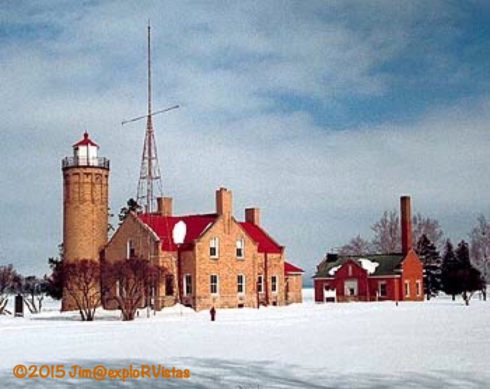
On the northernmost tip of the Lower Peninsula of Michigan is a place that is near and dear to our family…Old Mackinac Point.  On this ground in 1892, my maternal great-grandfather led his crew in building Old Mackinac Point Lighthouse and the barn that stands behind it.  The light station had been established three years before, and the first fog signal building became operational in 1890.  A request for bids for the lighthouse and barn went unanswered, and the second request in March of 1892 solicited three bids, with my great-grandfather’s being the lowest at $13,722.00.  He gathered his work party and boarded the lighthouse tender Amaranth at the Detroit Lighthouse Depot for the journey to Mackinaw City.

  
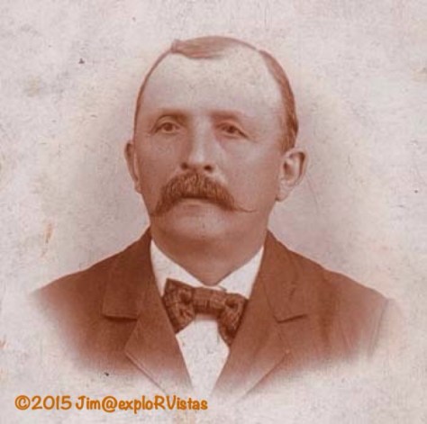
John Peter Schmitt was born in Germany in 1844.  He and his brother came to the United States in the 1870’s and took up the construction trade in Detroit.  The bell tower on St Joseph Catholic Church in Detroit is his work, as is St Anthony’s Catholic Church, just up Gratiot Avenue.  Both are still in use today. He and my great-grandmother had four girls who all died within a month of each other in a diphtheria epidemic that swept through Detroit in the late 1800’s.  They had and lost a fifth child following that.  They then had three more children, with my grandmother being the middle child.  My great-grandfather was 40 years old when she was born.  He lived until 1904, when his spirited horse took a corner in Detroit too fast and tipped his wagon over.  He cut his hand in the dirt street and developed tetanus, from which he died eight days later.  Another nine years past before my grandmother married. She gave birth to my mother at 38 years old and my mom had me when she was 36.  So while my great-grandfather and I are genetically close, there are 114 years separating our births!

When the crew arrived in Mackinaw City in May of 1892, work began in earnest. By October 25th, the first lighting of the lamp took place in the tower.  Considering the building is a two-story all-brick duplex, complete with basement, that was quite a feat!

  
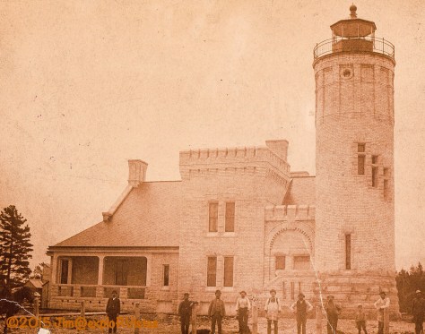
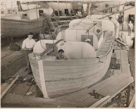
Here is the crew out in front of the partially completed lighthouse.  John Schmitt is directly below the double set of windows in the castle tower section of the building.  The next person to the right in the white shirt is his brother Tony.  The lens has yet to be installed in the tower in this photo.  If you look to the far left of the image, there is a horse poking its head in.

The lighthouse continued to guide ships through the Straits of Mackinac until 1957, when the Mackinac Bridge was completed.  The bridge’s lights were more than sufficient to provide safe passage after that.  For a short time after, the State of Michigan operated a maritime museum from the building, but no access to the tower was permitted.  Eventually, the museum closed.

In the 1990’s, my Aunt Marge visited the grounds and then wrote to the Mackinac State Historic Parks (MSHP) to inquire on the building’s status.  Diana and I visited not long after that, and we were concerned that this beauty was being left to decay. MSHP’s focus at that time was aimed towards the forts it maintains in both Mackinaw City and on Mackinac Island. Interest in lighthouses was really beginning to take off, and this was one of the most easily accessed lighthouses in Michigan.  It deserved to be opened, and in 1996, I began pressuring MSHP to do something.  It wasn’t long before they suggested I join a fund raising committee to raise the funds to restore the lighthouse. I took them up on that suggestion, and made several trips from Grand Rapids to Mackinaw City over the next few years to work with them.

  
Here is a February photo of mine from one of my trips up there.  Note the red and white lantern room, which was not historically correct.  The radio tower was also not part of the original station, and was moved off the property in later years.

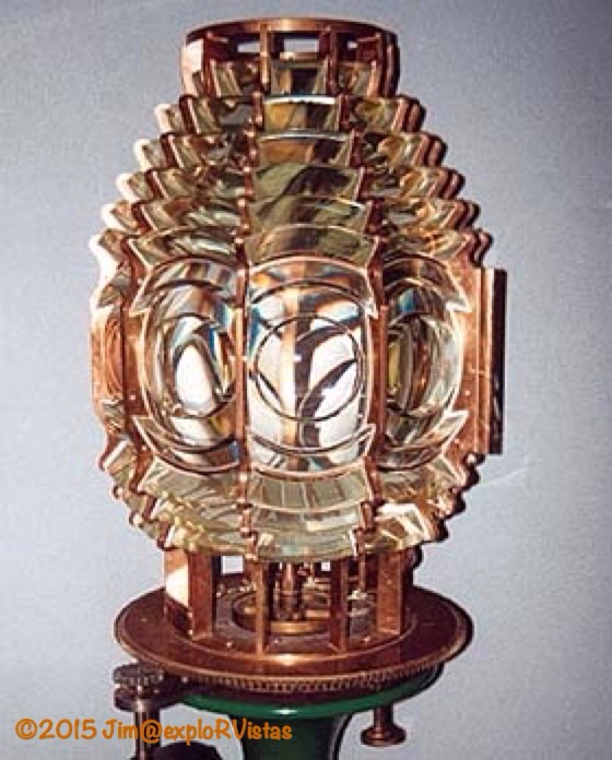
One of the questions I had was the whereabouts of the Fresnel lens.  I was told that it was destroyed when they tossed it off the tower after the lighthouse closed.  Turns out, it had actually been residing in the U.S. Coast Guard Ninth District Admiral’s office in the Federal Building in Cleveland, Ohio.  I contacted that office about being able to see the lens.  With permission granted, Diana and I made the trip to Cleveland.

  
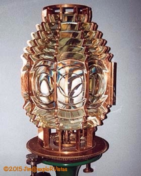
This is my photo from that day. A young Coast Guard officer gave us a special tour of the office.  There were several artifacts, but none as beautiful as our lens.  There was a small ceremonial cannon on the floor next to the lens, and the officer explained to us that the gun was there to signify that it was guarding something of great importance.  It sure was important to us!  To think that my great-grandfather was there to see it lit for the first time was overwhelming, to say the least.  It was obvious that the admiral treasured the lens, but Coast Guard rules stated that he had to return it to its original home, once the lighthouse had a proper place to display it on the first floor in a museum setting.  Senator Carl Levin’s office helped in making sure that happened.

In 2004, after a successful fundraising campaign, the lighthouse reopened.  Diana and I decided to host a family reunion of every descendant we could find of John Peter Schmitt to coincide with the grand opening.  Of the 300 people attending the celebration, 100 were our family.  Some of them travelled up from Marathon, Florida and Missouri to be part of the event. The reason I pushed MSHP so hard was for the family…especially John Peter Schmitt’s grandchildren.  As I write this today, almost all of his grandchildren have passed.  The two of us were thankful that we were able to make it all happen while they were still alive. 

A little magic happened that day.  Not only were the descendants of the builder there, but also of the lighthouse keepers.  One of the keeper’s relatives recognized one of my cousins, as their children attended the same high school north of Detroit.  Both were unaware of each other’s ties to the lighthouse.  That was a special moment.  🙂

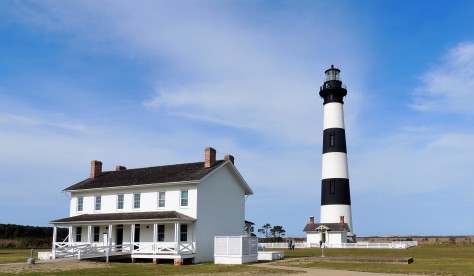
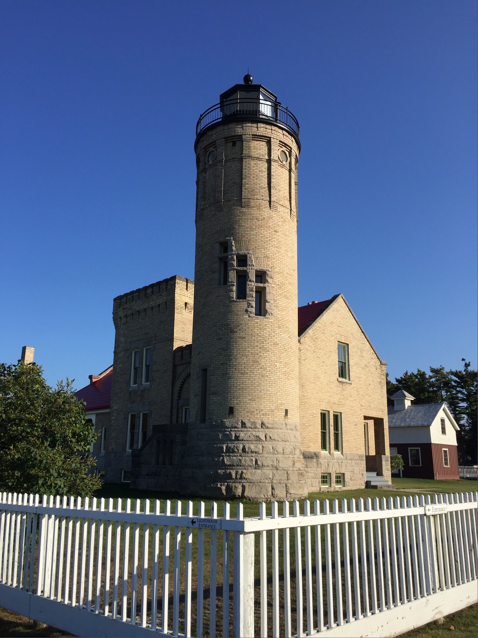
At the time of the grand opening, the only structures remaining at the light station were the lighthouse and the 1907 fog signal building. In the ensuing years, MSHP replicated the picket fence and the original fog signal building.  They also returned the barn to the site, which had been moved to the west side of Mackinaw City a number of years before.  Below are photos from our latest visit to the light station, which we toured on our way home from the U.P.

 
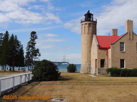
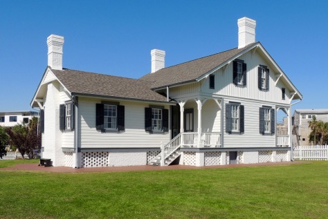
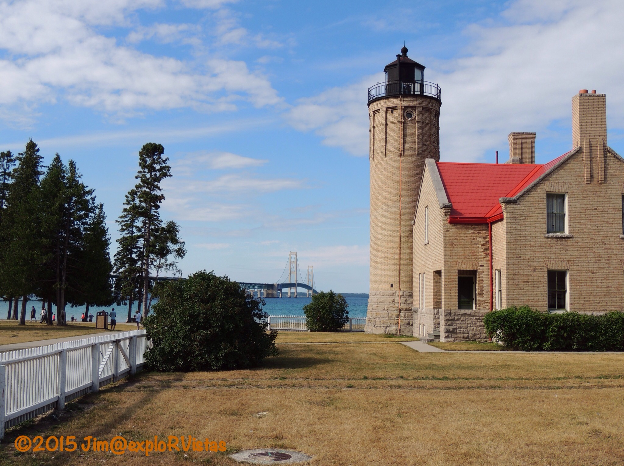
Looking north along the west side of the lighthouse, the proximity to the Mackinac Bridge can be seen.  Note the brown grass from the current drought conditions in the area.  The tire tracks in the yard are from the recent construction of the replicated 1890 fog signal building. The lantern room is back to its original black, and the picket fence has been replicated.


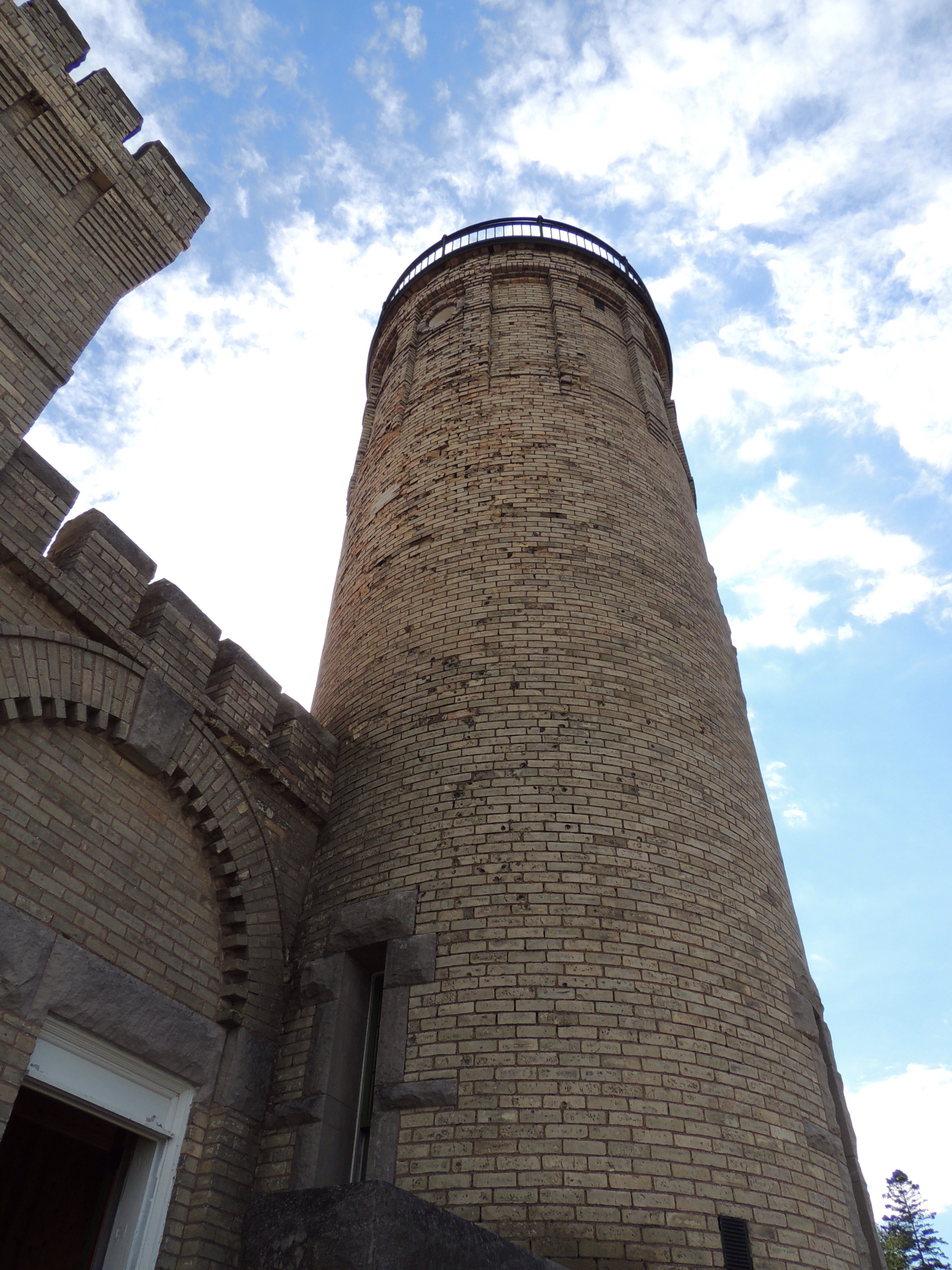
Standing watch for 123 years, the tower shows the effects of the harsh weather conditions at the Straits of Mackinac.  The bricks that the U.S. Lighthouse Service provided for construction were not the proper quality for the application, and the freeze/thaw cycles in the area began to cause them to deteriorate prematurely.  This has been an ongoing problem and there is no clear solution…short of re-bricking the entire structure.  In the previous photo, note the chimneys.  The original flared chimneys were replaced with straight rectangles at some point during the lighthouses working years, and MSHP has recently replicated one of them to its 1892 form.

  
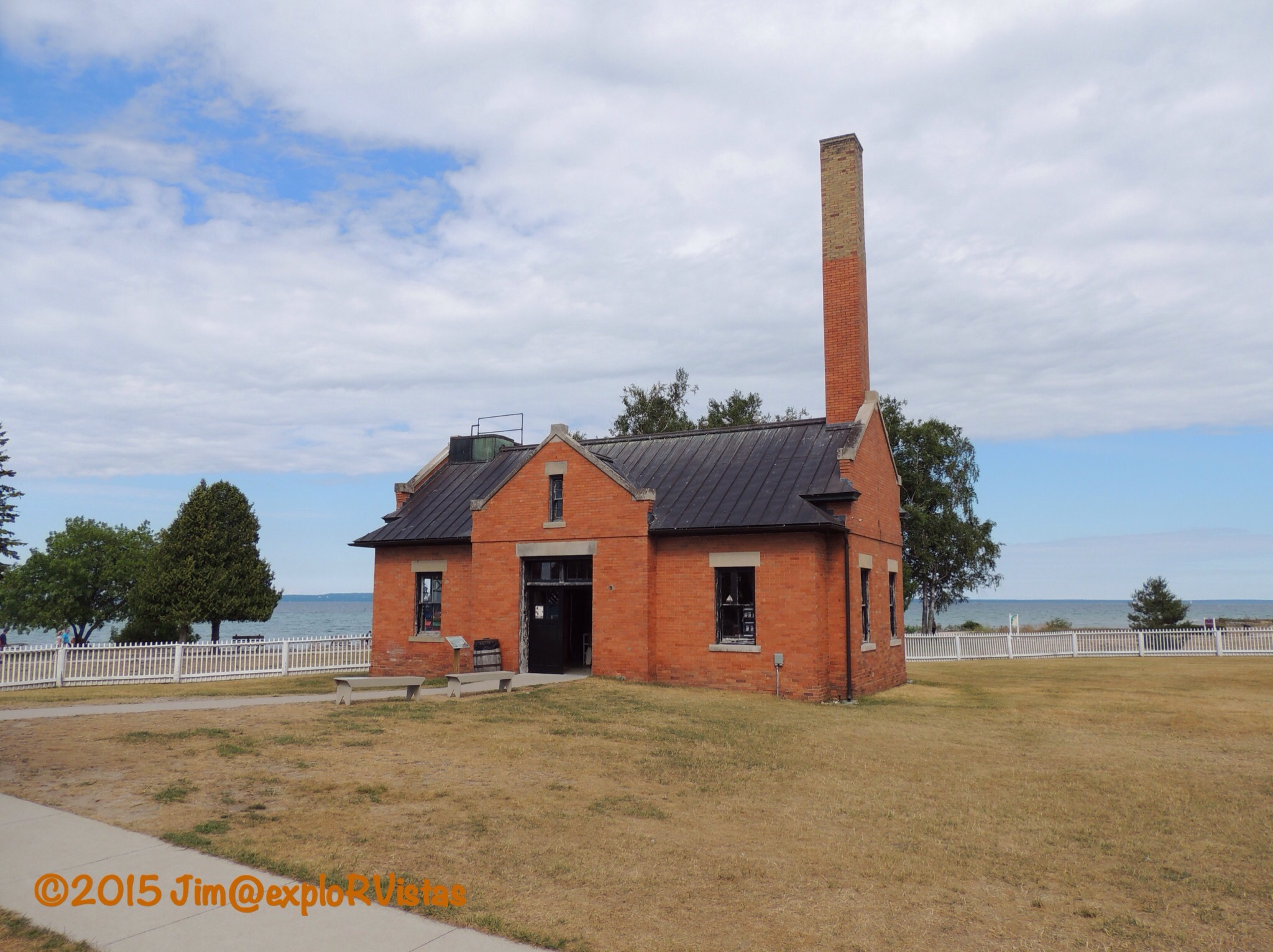
The 1907 fog signal building, built three years after my great-grandfather passed.  This building now serves as a gift shop and as the entrance to the station grounds. The original 1890 fog signal building was constructed too close to where the lighthouse was intended to sit, and was deemed a fire hazard.  It was moved to the southeast corner of the station as a storage barn, and was eventually torn down.

  
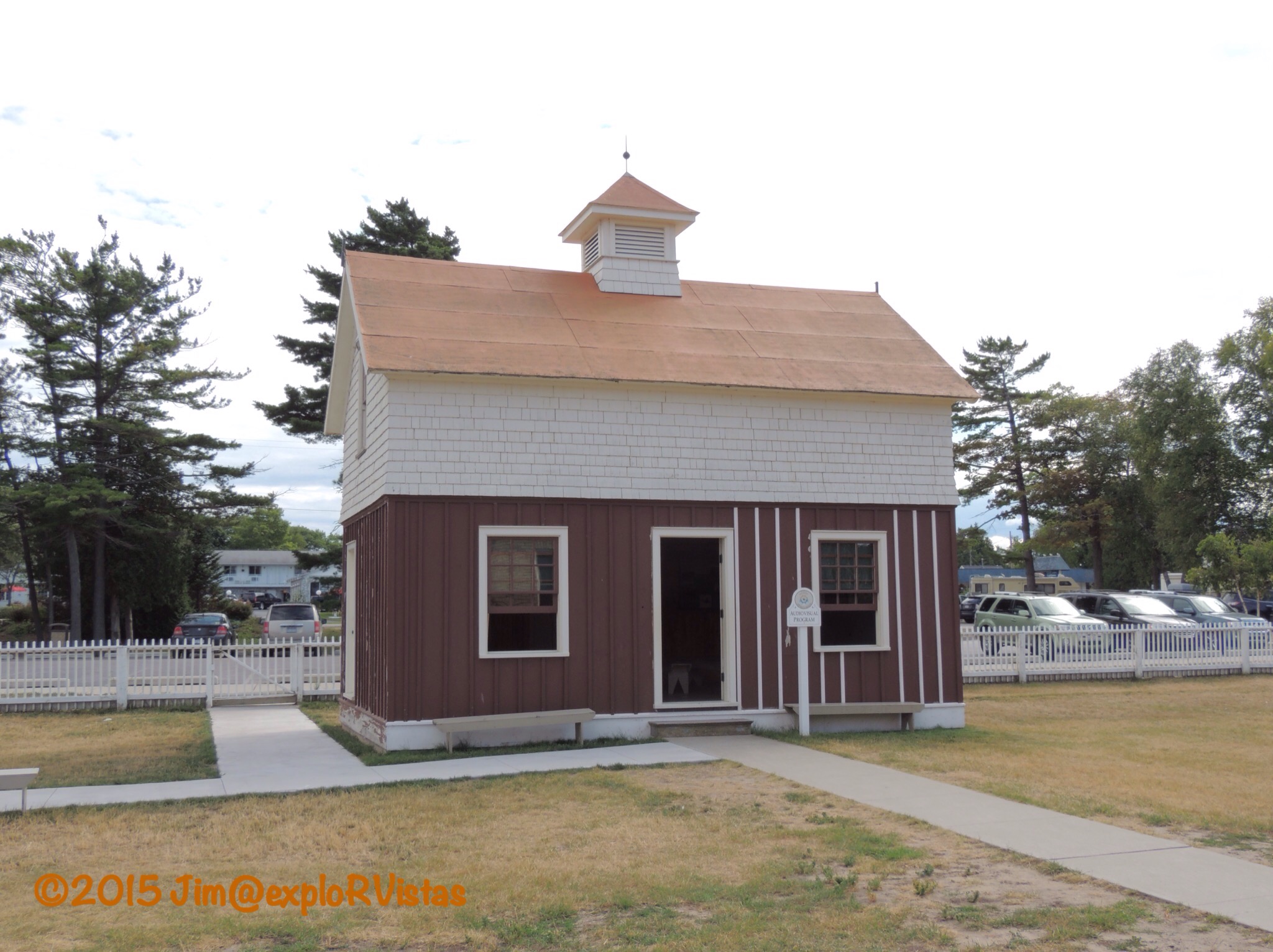
This is the barn John Peter Schmitt’s crew built.  It is in need of a paint job, which appears to be in process.  The building was moved to the west side of Mackinaw City, prior to the construction of I-75 and the Mackinac Bridge.  It was being used as a storage garage by MSHP In that location.  To bring it back, the trailer tires had to be deflated a little to fit the barn (minus the cupola) under the Mackinac Bridge approach.  Even then, there was green bridge paint that ended up on the peak of the barn’s roof.  🙂  Once it was returned to the station grounds, the structure was restored to its original appearance.  It now houses a theater that shows a video about the shipwrecks in the straits.

  
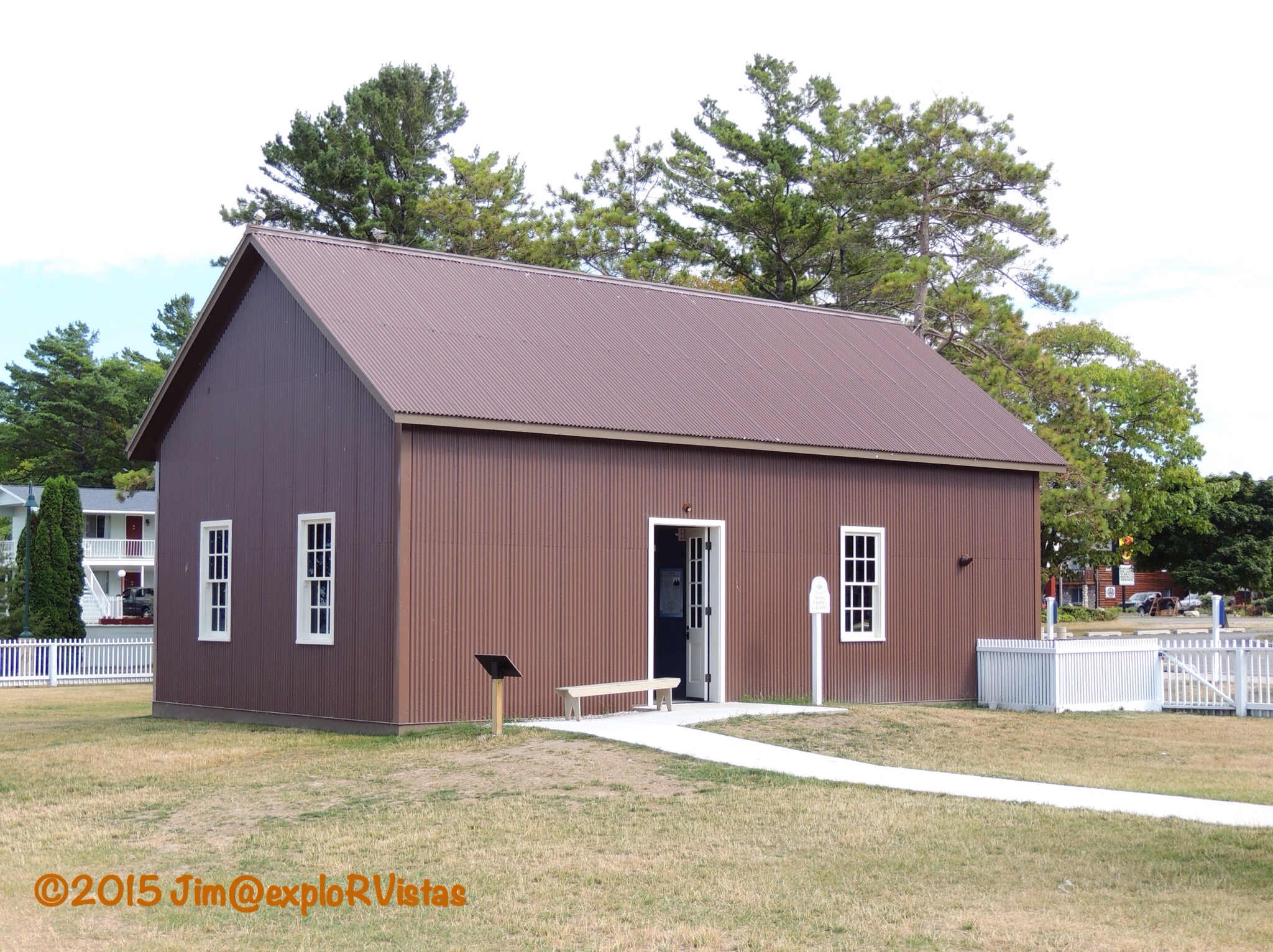
Here is the newly replicated 1890 fog signal building, situated in the location the original structure occupied during its service as a light station warehouse.  The corrugated cladding gives the exterior of the building an authentic feel.

  
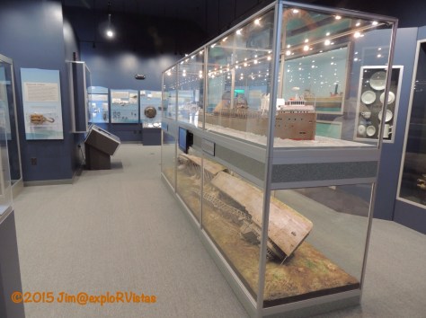
The interior of the building houses a beautiful shipwreck museum.  There are several displays with models of the original ships as they appeared on the surface, and the corresponding model of how each shipwreck currently sits at the bottom of the Straits of Mackinac.  This is the display of the 604 foot limestone carrier Cedarville, which was lost in heavy fog off Old Mackinac Point in 1965.  It collided with a Norwegian freighter, killing ten crewmembers.  It lies in two pieces in 110 feet of water.  Kudos to MSHP on this addition to the light station, as it is very well done.

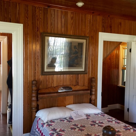
Inside the lighthouse itself, some of the rooms are restored to their 1910 appearance.  Other rooms have interactive displays.  The lens is also displayed behind a glass partition.

  
Tower tours are conducted every 15 minutes.  When I began working with MSHP to reopen the building, the director informed me that the tower would not be opened to the public, for safety reasons.  I knew that the museum’s success was dependent on public access to the tower, and we didn’t see eye-to-eye on the subject. Who wants to visit a lighthouse and not be able to climb the tower?  When that director took a job in Pennsylvania and Phil Porter took over his position, everything changed.  Tower tours became the featured attraction at the lighthouse, and the attendance numbers reflected that.

  
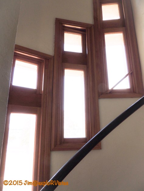
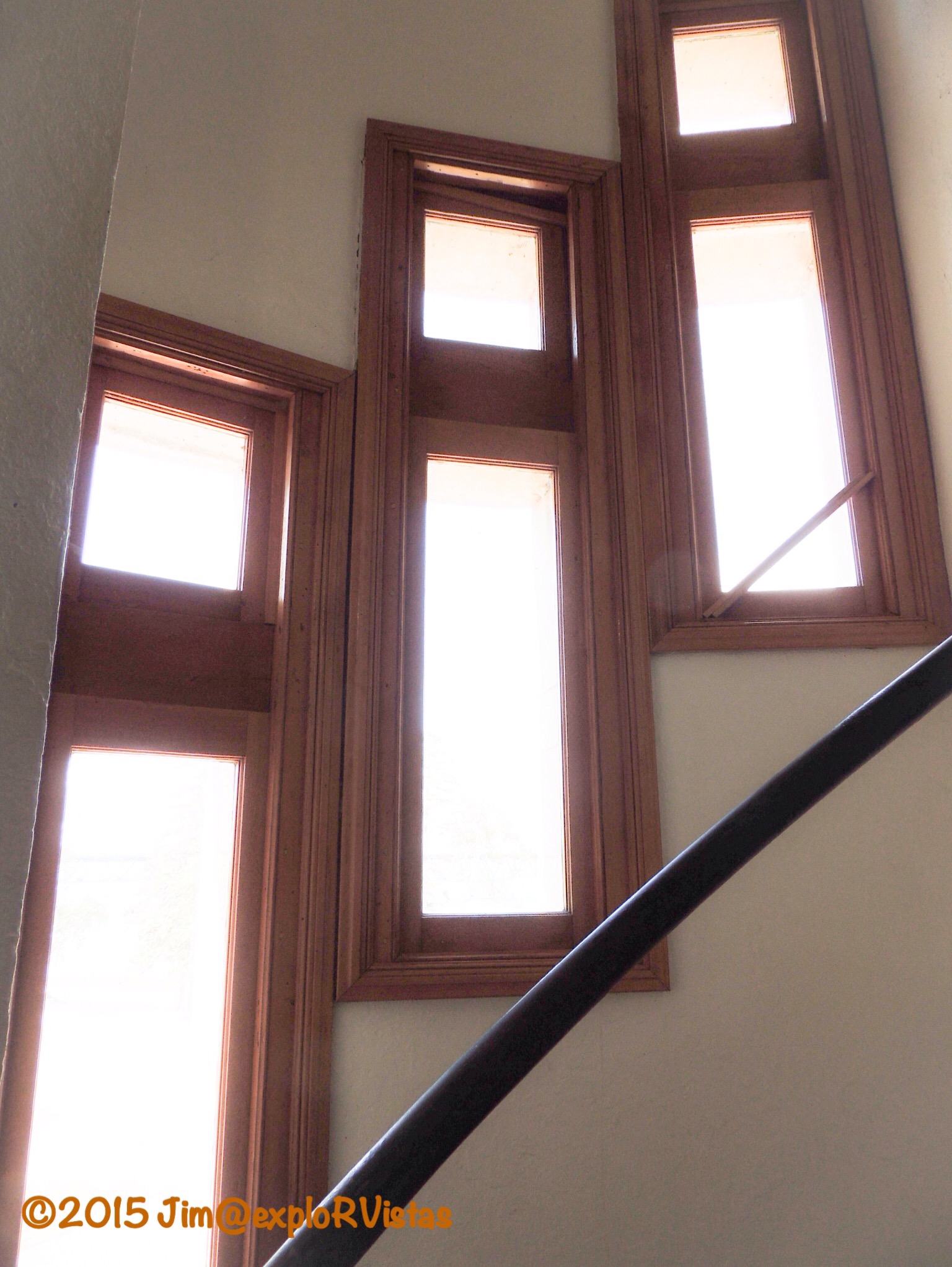
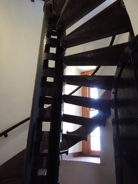
The unique ascending tower windows, as seen from the inside.

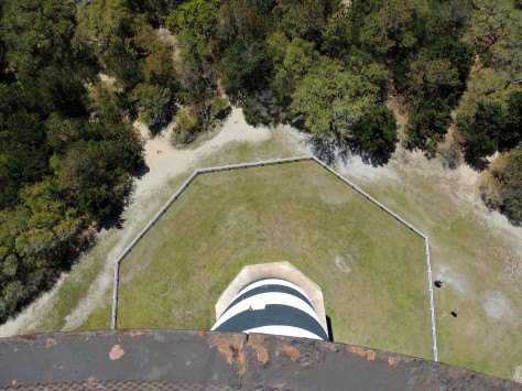
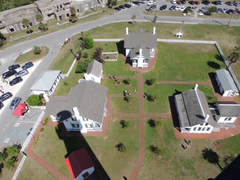
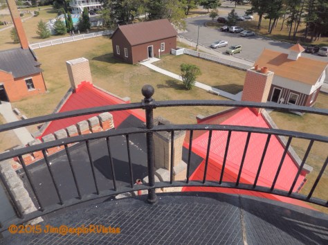
  The view from the lantern room looking down at the roof of the lighthouse, and the other structures on the station property.  The only buildings that are missing from the grounds are the cast iron oil house and the privy.  I’m not sure if there are plans for replicas of those in the future, or not.
  
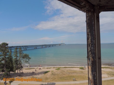
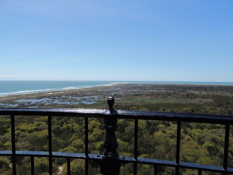
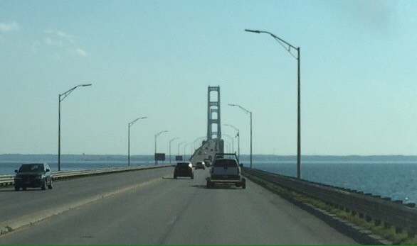
Looking north, the Mackinac Bridge stretches out for 5 miles to the Upper Peninsula of Michigan.

  
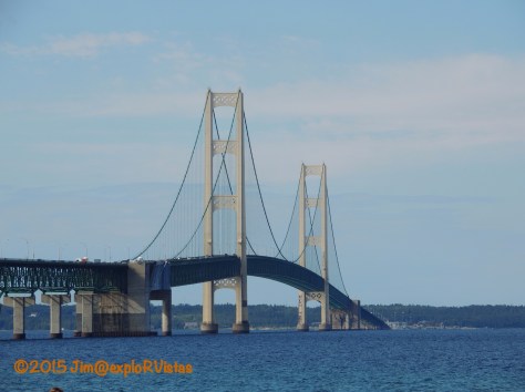
This graceful structure is what rendered the light station obsolete.  When it is lit up at night, it is pretty obvious to passing ships.

  
Needless to say, our family is pretty darn proud to have this lighthouse still standing, and to be open for future generations to discover.  If you find yourselves in Mackinaw City, take an hour and tour this special place.  We think you will enjoy it.   🙂