
Sometimes the hidden gems are found when you take your time…
For so many of our working years, our focus on the Michigan/Florida route was to get there…which involved only two overnights. To us, Alabama was mostly flat, as we slid down I-65 to Montgomery, then down US-231 to the Florida line. We knew there were many portions of the state we were missing, and that we were going to want to experience those at some point. We had the time on this trip, so ‘some point’ had arrived!
We pulled out of Huntsville on Saturday, October 28th and headed south on US-431. The first portion of the route took us through some beautiful waterside views of Guntersville Lake, which is actually the dammed-up Tennessee River. The remainder of the highway to our next stop in Oxford passed through a secession of towns that had grown together to become a bit more congested than pretty. Still, we found it far more interesting than I-65! 😊
We set up at CWGS (an acronym for Camping World / Good Sam) campground in Oxford, which is located right next door to the local Camping World. Our first intention for this two night stop was to grocery shop, do laundry, and sit out the rainy, cold day that was forecast for Sunday. With all tasks accomplished early in the day, and with clearing skies, we set out to do a little exploring. Just south of Oxford, the southern end of the Blue Ridge Mountains terminates in Cheaha State Park. This is Alabama’s highest point, a spot recently visited by our friends Debbie and Steve, on their quest to climb each state’s tallest peak.
After setting the GPS, we headed straight south out of Oxford. Several miles up the mountain, we came to a cable across the dirt road. Hmmm….it looks like Greta Garmin needs an update. Back down the mountain we went. We found the correct road, a 13 mile scenic route off of US-431.

The first turnout revealed that this was going to be a pretty drive! We continued on up to the top of the mountain and found a historic stone lookout tower, along with a sign declaring we were at Alabama’s pinnacle.

The tower was constructed in the 1930’s by the Civilian Conservation Corps, along with most of the parks buildings, bridges, and trails. They even constructed the dam that forms Cheaha Lake. There is a museum adjacent to the tower devoted to the CCC, and the tower itself is open to visitors. I asked the volunteer in the museum where the official benchmark was located…
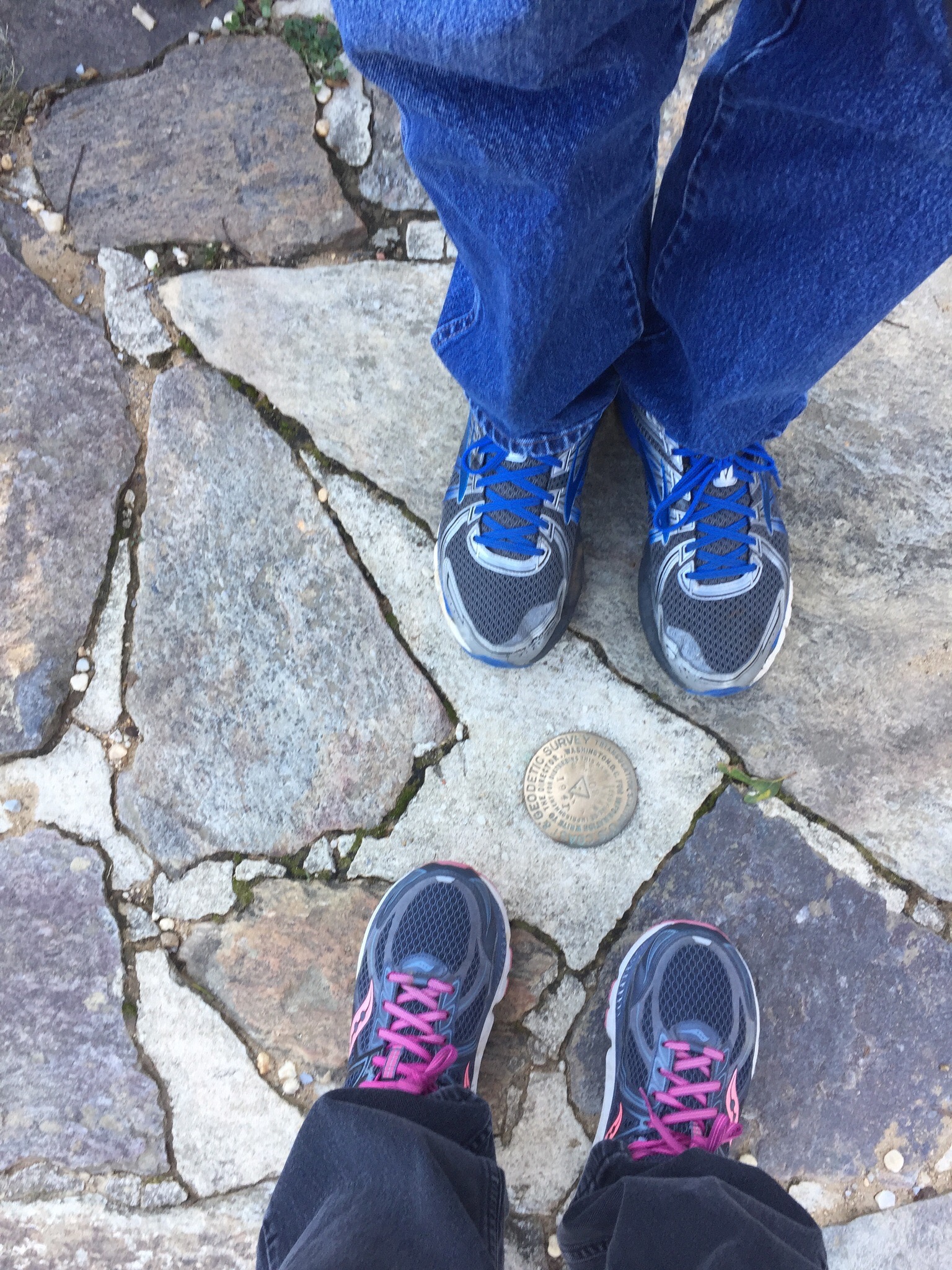
…and it turns out that we had practically stepped on it on our way inside. 😎
From there, we checked out an accessible boardwalk out to Bald Rock.

This very popular pathway parallels the old CCC trail that runs out to one of the best viewpoints in the park. Every so often, a stairway leads down to the original route.
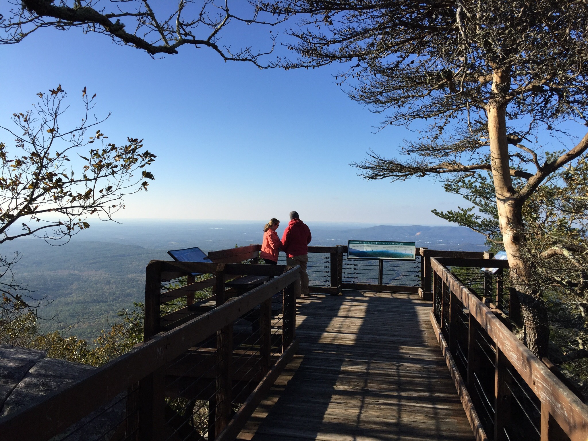
Coming around the corner toward the viewing platform, we catch our first glimpse of this amazing vista!
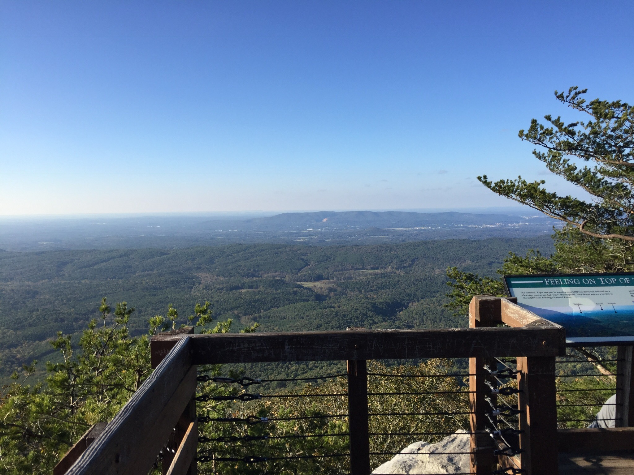
The view is absolutely stunning! And the fact it is accessible to all just makes it that much better.

Even though we were chilly, we thoroughly enjoyed our afternoon at Cheaha State Park! Be sure to stay tuned to see what we find on our next stop!
———-
Search and shop our exploRVistas Amazon link HERE !
———-
explorRVistas is a participant in the Amazon Services LLC Associates Program, an affiliate advertising program designed to provide a means for sites to earn advertising fees by advertising and linking to Amazon .com. Shopping through our link does not add anything to your cost, but it does help support this blog. Thank you for shopping through exploRVistas!

Wow, the view from that platform is awesome and definitely unexpected! But man, it looks chilly!! We’re in southern Alabama right now and we’ve actually been hot all week (not that we’re complaining)…. Crazy what a difference a couple days and couple (hundred) miles can make!
LikeLiked by 1 person
I think it was more the days than the miles, as that was that deep cold trough that slid by. We warmed up pretty soon after that stop. 😊
LikeLiked by 1 person
Great view and only 2,400 feet elevation.
LikeLiked by 1 person
And no real climb to get to it, Linda! From the car, that boardwalk was fairly flat. 😊
LikeLiked by 1 person
Brrrr! You sure look chilly. But what a great view. There are so many hidden gems in this country.
LikeLiked by 1 person
It was really windy up there, and the night before had dropped down to 30 degrees, Pam. Definitely chilly for that far south in late October!
LikeLike
You both looked so cold! And yes there are a lot of hidden gems in Alabama!
LikeLiked by 1 person
I think our Michigan blood has turned into Florida blood, MonaLiza! 😬
LikeLike
I’m sure the beautiful view was worth bundling up. I’ve become so accustomed to warmer weather that it doesn’t take the thermometer to drop much before I’m throwing on a sweatshirt. Safe travels.
LikeLiked by 1 person
That’s pretty much where we are, Ingrid! 😊
LikeLike
You guys look very bundled up … great views though.
LikeLiked by 1 person
It was a very brisk and windy day, Deb. Much better now!
LikeLike
The yellow hoodie is too cute
LikeLiked by 1 person
😊
LikeLike
Great views up there, I wonder if the McCormicks have hit that high point, maybe you have one up on them!
LikeLiked by 1 person
They sure did, Jim! If we want to get one up on them, we need to head up to Denali 😉
LikeLike
What a pretty stop!! Love those “because we have time” locations along the way. Wow, not everyone can follow in Debbie and Steve’s mountain climbing tracks – good job :-))) Gorgeous views from the chilly platform!
LikeLiked by 1 person
Well, we did let Edsel do most of the climbing, Jodee. Just a few stairs at the end to get to that benchmark. 😉 Definitely a worthwhile stop!
LikeLike
You found a Camping World that has an actually campground with it? That’s interesting!
Nice little side trip, I never considered Alabama to be that mountainous. You guys look just a tad chilly.
LikeLiked by 1 person
You never know what Marcus Lemonis is up to with CW! We were a little chilly that day, Bob. That first cold snap was moving through.
LikeLike